

April 2024 Climate Summary
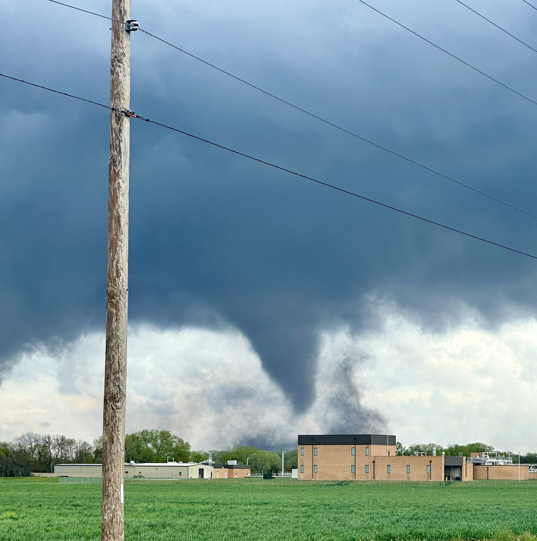
Tornado north of Lincoln, Nebraska, Photo Courtesy of Gannon Rush
Regional Breakdown
Severe weather significantly ramped up this month, with one of the more impactful outbreaks in recent years striking the southern parts of the region at the end of the month. Heavy precipitation and downpours with the multiple rounds of storms led to tremendous recorded totals.
After several weeks of scattered severe storms, conditions rapidly became favorable towards the end of the month. Several weak tornadoes and reports of 3-inch (7.62 cm) hail struck western Kansas and eastern Colorado on the 25th, setting the stage for what was to come.
The next day, eastern Nebraska was ravaged by an onslaught of strong tornadoes. Multiple EF-3s struck the state for the first time since 2014, wreaking havoc along their paths. Lincoln narrowly avoided a direct hit, with a large tornado packing 158 mph (254 km/h) winds touching down just on the edge of town. It would track across Interstate 80, before dissipating just outside of Waverly. The same storm would spawn a mile-wide (1.6 km) behemoth that would cause devastating damage to the towns of Elkhorn, Bennington, and Blair on the outskirts of Omaha with 165 mph (266 km/h) winds. Homes were leveled and cars were tossed like ragdolls during its 30-mile (48 km) reign of terror. Downtown Omaha also escaped a near disaster, with another EF-3 touching down at Eppley Airfield. Several hangers and planes were destroyed, with the tornado tracking across the airport before crossing into Iowa. Despite the disaster that had unfolded, there were only a small number of injuries from the tornadoes on the 26th.
After several more rounds of severe weather in the following days, the month concluded with an outbreak in Kansas. Several tornadoes touched down, with one dangerously close to Topeka. One did impact the town of Westmoreland, with the EF-3 causing exceptional damage and one fatality.


Precipitation and Water Resources
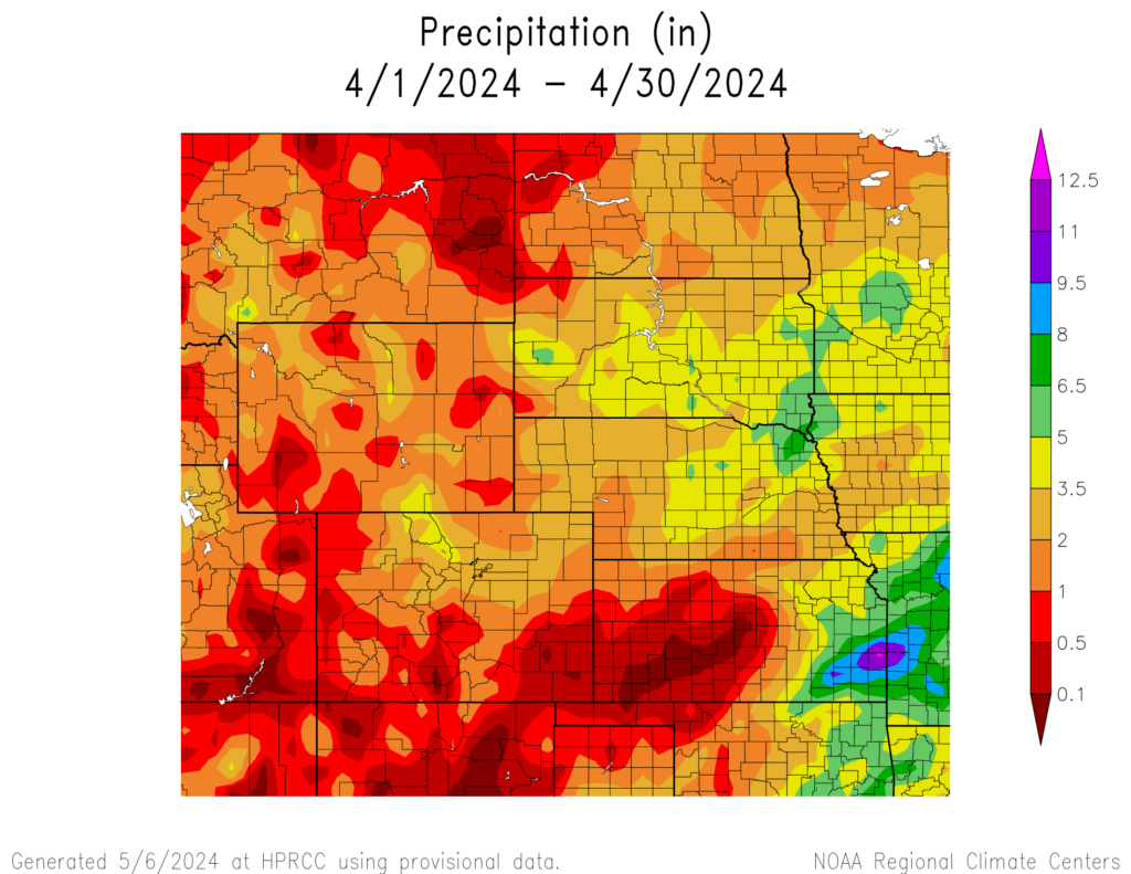
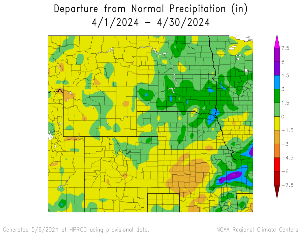
The northern High Plains and eastern Kansas received normal to above normal precipitation this month, while others were not as fortunate. Parts of western Kansas are on their second month in a row of well below to near zero amounts.
Areas around in southeastern Kansas had buckets of rain dumped on them at the end of the month. Fort Scott and the surrounding areas recorded over 10 inches (25.4 cm) from the 26th to the 28th. Much of this fell on the 28th when locations such as Humboldt observed 8.10 inches (20.57 cm).
To the north in South Dakota, several locations were in the top 10 wettest. The town of Martin recorded their wettest April on record, with 4.23 inches (10.74 cm) this month. Rapid City in the west ranked 5th and Pierre in the central part of the state ranked 7th.
On the flip side, western Kansas has once again entered an extended period of missing out on any meaningful precipitation. Dodge City tied with 1909 for their driest April, while also ranking 3rd for driest March-April. Nearby places such as Bucklin, Cimarron, and Offerle ranked driest for the two months, with only those locations receiving around 0.25 inches of precipitation (0.64 cm).
With the melt-off of snowpack in the mountains imminent or underway, the basins in Colorado and Wyoming are in decent shape. Snow Water Equivalent (SWE) was near normal, which should benefit rivers and streams. Streamflow improved in Nebraska thanks to the heavy precipitation, however, central Kansas remains low.
Temperatures
Warmer temperatures returned this month, with the region experiencing slightly above-normal temperatures. Outside of an anomaly, the southern half of the region likely observed their last frost this month. Average temperatures this month were 2 to 4 degrees F (1.1 to 2.2 degrees C) above normal this month.
While temperatures were slightly above normal this month, there were no significant records broken. This does, however, continue a trend that stretches back to the beginning of the year with large portions of the region 4 degrees F (2.2 degrees C) above normal. Many locations rank in the top 10 for the warmest January through April, with several locations in the region ranking in the top 5. Sioux Falls, South Dakota and Grand Forks, North Dakota recorded their 4th warmest start to the year, thanks in part to a strong El Nino this winter. Scattered throughout the region ranking as 3rd warmest include Fargo, North Dakota, Grand Junction, Colorado, and Laramie, Wyoming.
Drought Conditions
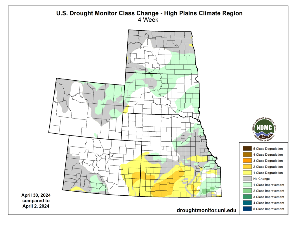
Heavy precipitation this month improved drought conditions for some, while others were not as fortunate. Up to 2 classes of change occurred on both ends of the spectrum, with an overall reduction of 6 percent of D0 to D4 (abnormally dry to exceptional drought conditions) in the High Plains.
After steadily climbing out of a significant drought, Kansas took a big step backward this month. At the beginning of April, less than 2 percent of the state was experiencing D2 (severe drought). Over the month, it rapidly rose to over 27 percent. Much of the western part of the state slipped back into drought conditions, after a short period of being close to drought free.
The Dakotas received beneficial precipitation this month, reducing the extent of D0 conditions across both states. Most of South Dakota is drought-free, while conditions in northeastern North Dakota remain firmly entrenched. Elsewhere in the region, other improvements and degradation were observed. According to the Climate Prediction Center’s U.S. Monthly Drought Outlook for May, drought conditions will improve in Kansas, Nebraska, and North Dakota.

Department of Agriculture (USDA), National Drought Mitigation
Center, U.S. Department of Commerce, and the National Oceanic and
Atmospheric Administration (NOAA). For current Drought Monitor
information, please see: http://droughtmonitor.unl.edu/
Climate Outlooks
According to the Climate Prediction Center, El Niño conditions are likely to continue but transition towards ENSO-neutral in mid to late Spring. An El Niño advisory and La Niña watch is currently in effect. For more information, visit https://www.cpc.ncep.noaa.gov/products/analysis_monitoring/lanina/enso_evolution-status-fcsts-web.pdf
The National Weather Service’s long-range flood outlook indicates elevated chances of Minor and Moderate Flooding in the eastern parts of Kansas through the end of June. According to the National Interagency Fire Center (NIFC), fire potential will be elevated in South Dakota, eastern Colorado, and western Kansas in April.
The seasonal temperature and precipitation outlook presented below combine the effects of long-term trends, soil moisture, and when applicable, the El Niño Southern Oscillation (ENSO). To learn more about these outlooks, please visit http://www.cpc.ncep.noaa.gov.
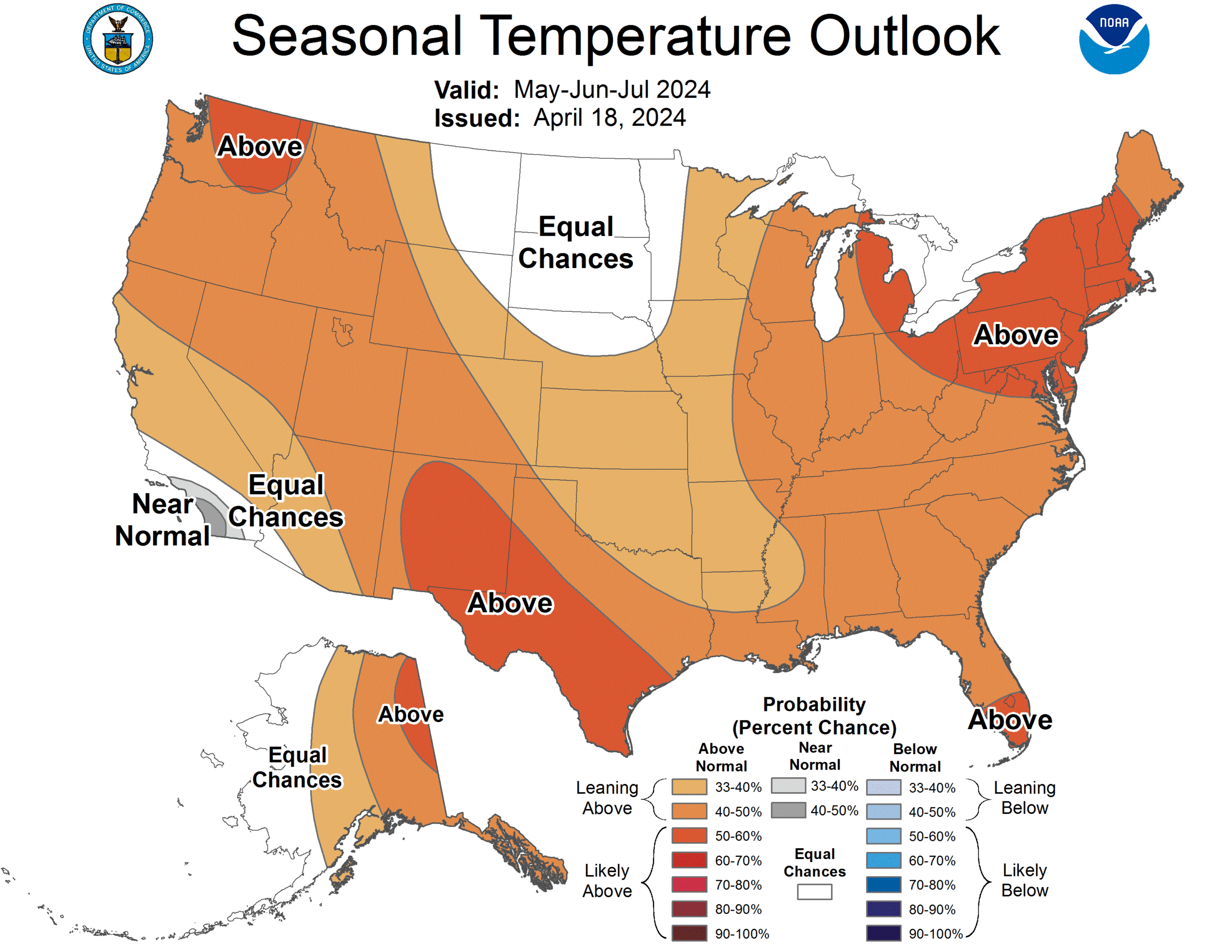
Temperature
The three-month temperature outlook shows an increased chance of above-normal temperatures across the much of the United States. Above-normal temperatures are slightly favored across Colorado, Kansas, Nebraska, and Wyoming.
Precipitation
The outlook for the next three months indicates below-normal precipitation across the Pacific Northwest and the Southwest, while above-normal precipitation is favored for the southeastern United States. Slight chances of below normal precipitation are possible in western Colorado.

Drought
The U.S Seasonal Drought Outlook released on April 30th indicates that improvements to drought conditions will occur across the region except for Colorado.

Station Summaries: By the Number
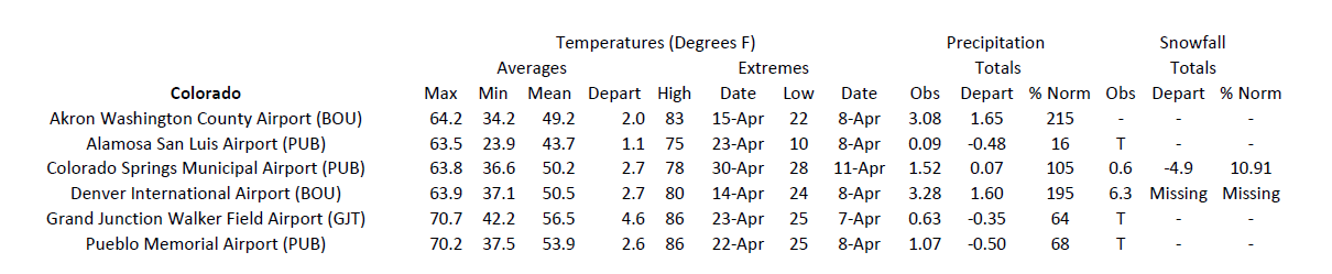

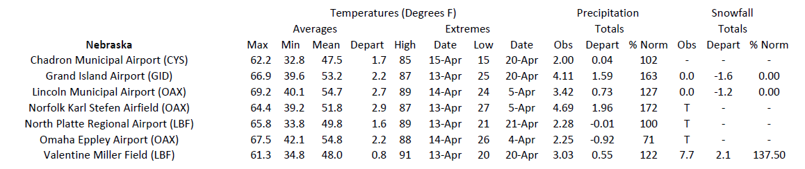


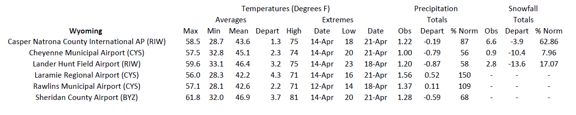
Download PDF Below