2023 Annual Climate Summary
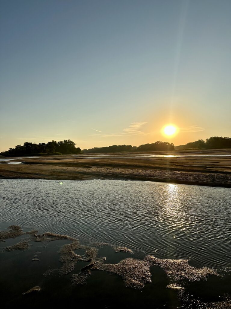
Rain approaching Glacier National Park in Montana. Photo courtesy of Gannon Rush.
Regional Breakdown
Climate-wise, 2023 was the opposite of 2022, which was marked by dryness and extreme drought. This year brought ample to plentiful precipitation to much of the region, which greatly improved drought conditions. While the precipitation was beneficial to mitigate drought conditions, it was too late to help some crops to recover. In August, a blistering heatwave further impacted all facets of life including agriculture. This heatwave led to a warm end to the year, culminating in a record-breaking December.


by the High Plains Regional Climate Center and are available at: http://hprcc.unl.edu/maps/current .
Precipitation
Precipitation came in spurts this year, with extreme amounts of precipitation occurring during several months. Snowfall was abundant in South Dakota, Wyoming, and northern Nebraska to start the year, but the rest of the region was rather dry. An onslaught of storms in May dumped generous amounts of rain across eastern Colorado, northwestern Kansas, and southwestern Nebraska, greatly improving drought conditions. Rain continued to pour into July for Colorado and Wyoming, with record wetness. Throughout the rest of the year, precipitation was not as widespread, however, those that did receive some were given generous amounts. Several locations recorded their wettest year, thanks to heavy snowfall at the beginning of the year and heavy rainfall towards the end. Compared to the extreme dryness that characterized 2022, this year leaves the region in much better shape heading into 2024.
Severe weather, particularly wind and hail, ravaged Colorado, Nebraska, and Wyoming this year. Colorado recorded their highest number of severe thunderstorm and tornado warnings issued in a year (period of record 2002-2023), with 1366. The Dakotas were the opposite, with a near-record low number of warnings issued. Hail wreaked havoc in Colorado, with two storms among the most notable. A hailstorm on June 21st interrupted a concert at the Red Rocks Amphitheater outside of Denver, with nearly 100 people injured after failing to heed warnings. The other storm occurred on August 8th, when a 5.25-inch (13.34 cm) hailstone fell outside of Kirk. After verification by the State Climate Extremes Committee, this would officially beat out the previous record of 4.83 inches (12.27 cm) from a stone from Bethune in 2019. In Kansas, a 115 mph (185 km/h) wind gust was recorded outside of Wallace. Combined with 2.5-inch (6.35 cm) hail, severe damage was reported from anything in the path of the deadly storm.
The following locations had notable precipitation records during 2023:
- Chadron, Nebraska observed its wettest year on record, with 23.85 inches (60.58 cm) of precipitation beating out the previous record of 21.60 in (54.86 cm) set in 1947.
- Record monthly single-day rainfall occurred in October. On October 12th, 7.39 inches (18.77 cm) fell near Ewing, Nebraska establishing the new single-day record. Then on the following day, 5.90 inches (14.99 cm) fell outside of Fairfax, South Dakota, also setting a new record.
- A CoCoRaHS observer southwest of Osage City, Kansas reported 9.35 inch (23.75 cm) of rain on October 25th. This would be the second highest single-day precipitation total for the month in Kansas.
- Culbertson, located in western Nebraska recorded their driest year in 2022, with 10.87 inches (27.61 cm) of precipitation. On the other hand, in May 2023, nearly the same amount of precipitation [10.65 inches (27.05 cm)] was recorded in Culbertson. To the east, near McCook, CoCoRaHS observers reported totals up to 14 inches (35.56 cm) precipitation.
- Eastern Kansas was buried under a pile of snow on Thanksgiving weekend. Several cities including Wichita received more snow from this single event than last winter. It was also the largest November snowstorm for Wichita since 1906.
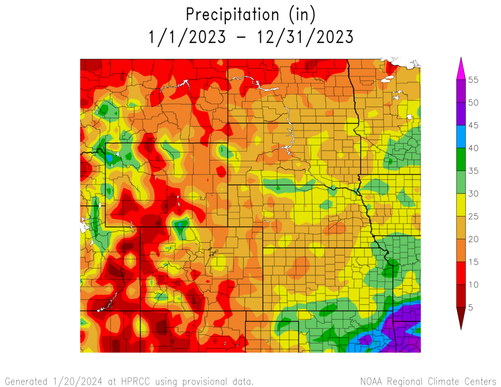

precipitation in inches (bottom) for 2023. These maps are produced
by HPRCC and can be found on the Current Climate Summary Maps
page at: http://hprcc.unl.edu/maps/current
Temperature
Overall, temperatures this year were slightly above normal for most of the region. Wyoming and parts of Colorado observed below normal temperature due to a very cool start of the year. Temperatures were mild for the rest of the region outside of May and June, before the entire region heated up from August until the end of the year. Multiple heatwaves impacted the region during the late summer and well into the fall, with temperatures surpassing 90 degrees F (32.2 degrees C) in Kansas during November. A dangerous and unbearable heatwave combined with extremely high dewpoints in August led to heat indices topping 130 degrees F (54.4 degrees C) in the southern Plains.
The following locations had notable temperature records during 2023:
- The heat index reached 134 degrees F (56.7 degrees C) on August 20th in the midst of a historic heatwave. Dew points would reach up to 84 degrees F (28.9 degrees C) in some places, creating very unhealthy conditions.
- John Redmond Lake (outside of Emporia, Kansas) observed its warmest year on record with an average temperature of 59.8 degrees F (15.4 degrees C). To the north, Concordia narrowly missed their record warm year.
- From January to March, the average temperature in Lander, Wyoming was 16.4 degrees F (-8.7 degrees C). It was their coldest start to a year on record.
- Grand Forks and Fargo, North Dakota recorded their warmest June on record, which came on the heels of near-record warmth in May. This was an extreme contrast to the beginning of the year when below-normal temperatures dominated the state.
- Grand Junction, Colorado tied their all-time warmest temperature of 107 degrees F (41.7 degrees C) on July 17th. A few days later, Lawerence, Kansas recorded its warmest July low temperature of 84 degrees F (28.9 degrees C) on the 27th.
- December was very warm in the region, with temperatures over 12 degrees F (6.7 degrees C) above normal in the northern portions. Monthly records were broken all the way from North Dakota to Nebraska, while the rest of the region ranked in the top 10 warmest.
Drought Conditions
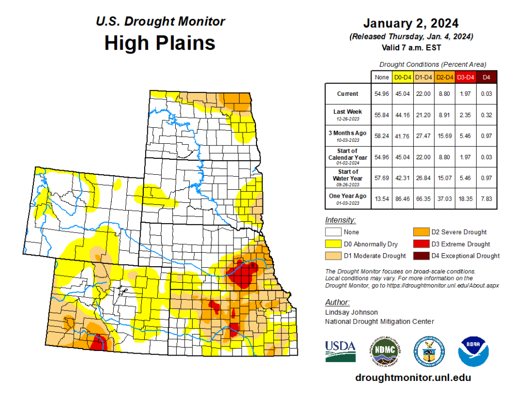
According to the U.S. Drought Monitor, overall drought coverage dramatically improved across the region. Heavy precipitation occurred this year primarily over areas plagued by drought coming into 2023.
Undoubtedly, the biggest winner in 2023 was Kansas. Entering the year, close to 57 percent of the state was under extreme to exceptional drought (D3-D4) conditions. That number is down to 3 percent heading into 2024, a significant and much overdue improvement. While much of the state is still dealing with drought or abnormally dry (D0) conditions, the outlook is much more optimistic heading into the new year.
Nebraska also improved significantly this year, however, the drought that does remain is intense. In the beginning of January, 99.75 percent of the state was affected by moderate to exceptional drought (D1-D4). By the end of the year, it was reduced by 73 percent with only the southeastern part of the state remaining under significant drought.
The Dakotas also experienced noticeable improvements, with both states experiencing a 60 percent reduction in D1-D4 conditions over the year. South Dakota is also primed to have further reductions to drought conditions early in the new year after a winter storm impacted the state around Christmas.
In a reversal from last year, drought conditions are in manageable and decent condition heading into 2024. Overall, 21 percent of the High Plains was in D1-D4 at the end of the year, the lowest percentage since May 2020.
Department of Agriculture (USDA), National Drought Mitigation
Center, U.S. Department of Commerce, and the National Oceanic and
Atmospheric Administration (NOAA). For current Drought Monitor
information, please see: http://droughtmonitor.unl.edu/.
Noteworthy Events
Record-Breaking Hailstone in Colorado: Capping off an unusually active severe weather season in Colorado was the recovery and examination of a 5.25-inch (13.34 cm) hailstone on August 8th in Yuma County. A storm chaser reported significant hail near the town of Kirk and managed to recover a stone larger than a softball. With a caliper on-hand, he was able to photograph some measurements, but some melting occurred before it could be officially measured. The local National Weather Service office in Goodland, Kansas convened the State Climate Extremes Committee to verify if it would break the recent record of 4.83 inches (12.27 cm) in 2019. Despite the melting during transportation, the initial measurements and photographs were sufficient evidence to certify that it would become the new record for the state.
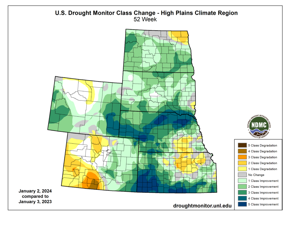
Drought Improvement Across the Region: The outlook for the multi-year drought in the High Plains seemed very bleak coming into 2023, with the previous year leaving Kansas and Nebraska in a dire situation. After multiple months of torrential rainfall, both states experienced significant improvements. D3-D4 was nearly eradicated in Kansas, however, a small patch does remain in Nebraska. The region as a whole is at the lowest percentage of drought conditions in nearly three years.
Agriculture Struggled Again: Despite the beneficial and significant amounts of precipitation, it was too late to improve winter wheat yields. Kansas harvested its lowest bushel count since 1966, with numerous fields abandoned due to the dry fall in 2022. Corn production was aided by the rains, however, the heatwave in August burnt many stalks to a crisp. North Dakota also recorded its largest cattle anthrax outbreak since 2005 due to a dry to suddenly wet pattern. The mild fall this year allowed the disease to linger, with a case reported in December.
Late August Heatwave: A rather unusual and deadly heatwave impacted the lower Plains in August. Temperatures reached up to 115 degrees F (46.1 degrees C) in Manhattan, Kansas and the average high for the week was 108 degrees F (42.2 degrees C). The presence of dewpoints up to 80 degrees F (26.7 degrees C) made this heatwave so unusual. Over 1000 temperature records were broken, with significant disruptions to daily life. Record power usage was recorded, placing a serious strain on utility providers. Schools in Kansas and Nebraska canceled classes or released students early to limit heat exposure outside or on buses.

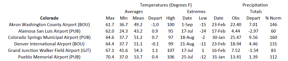
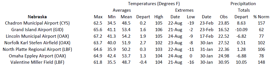
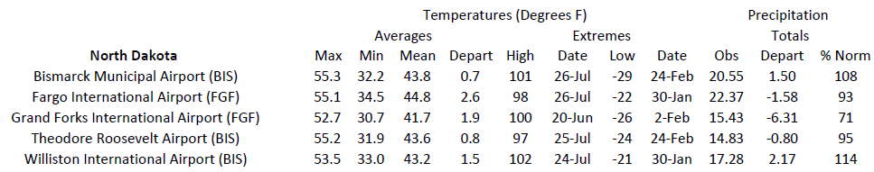
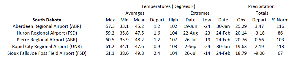
Station Summaries: By the Numbers