2021 Annual Climate Summary
Sunset in Lincoln, NE. Photo courtesy Heleena Pettee, High Plains Regional Climate Center.
A Year of Extremes
2021 was a year of extremes in the High Plains. January began the year with above normal temperatures across the region. Monthly temperature departures were as high as 15.0 degrees F (8.3 degrees C) above normal. This warmth led to drought expansion in the Dakotas which is abnormal to see in winter. Historic cold gripped the region in February as bitter cold persisted for 1-2 weeks, which made this event particularly impressive due to its longevity. Avalanche danger was extremely high in the Rockies throughout the winter as early season snowfall was weakened by dry conditions. The Southern portion of the region experienced an extremely wet early spring with above normal precipitation. The heavy precipitation recharged soil moisture and built snowpack in the mountains. Despite this heavy precipitation, flooding was limited in the region due to dry soil conditions.
Drought conditions intensified and expanded throughout the spring and persisted through the remainder of the year. Drought conditions were most extreme in the Northern Plains where crops and rangelands were impacted by the lack of moisture and heat. Over 80 percent of pastures and rangeland in the Dakotas were in poor to very poor conditions by the end of the summer. Poor forage, low stock ponds, and pests led to increased cattle sales across the region. The dry conditions and heat impacted crops and led to early maturation
and harvest. Pollinators and wildlife were also impacted as a result of drought conditions. Dwindling beehives led to a decrease in the Dakotas honey production this year. Fawn survival rates were lower than average with a lack of forage and some fish populations decreased from low river levels. As 2021 came to an end, 65 percent of the region in D1-D3 conditions, and 88 percent of the region remained in abnormally dry (D0) conditions.


by the High Plains Regional Climate Center and are available at: http://hprcc.unl.edu/maps/current .
Precipitation
2021 remained another dry year across the High Plains. The majority of the region experienced below normal precipitation for the year. While late winter and early spring started off wet in the region, that quickly changed as summer began and drought conditions started to expand and worsen throughout the remainder of the year. While only a couple of locations ranked in the top 10 wettest/driest for the year, many locations set new monthly records throughout 2021. Chadron, NE ranked the 5th driest year on record with 11.50 inches (292.1
mm) of precipitation recorded for the year. In contrast, Sisseton, SD had their 8th wettest year on record with a total of 28.98 inches (736.1 mm) of precipitation.
Snowpack for the 2020-21 season was below normal for the region resulting in portions of the upper Missouri River Basin runoff being much lower than average. Snow Water Equivalent (SWE) peaked above Fort Reservoir at the end of March with 86 percent of the normal peak, while the reach between Fort Peck and Garrison Reservoirs peaked at the end of April at 96 percent of the normal peak. Both areas ended the season below average with Snow Water Equivalent (SWE) 80 percent of average above Fort Peck Reservoir and 65 percent of average between Fort Peck and Garrison reservoirs. As a result, as summer began, Basin runoff was 69 percent of average. As this year’s snow season (2021-2022) began, early season snowpack across the region is below normal as a result of a warmer and drier start to the winter season. While it is still early in the 2021-2022 season, this can become a concern to farmers as they look to spring planting.
The severe weather season in the region was less active for the year. In June, only four tornado warnings were issued across Kansas, which is well below the June average of 29 (based on data going back to 1986). At the end of peak severe weather season in July for the High Plains, every state aside from Colorado was 50 percent below their yearly total for tornadoes, according to the Storm Prediction Center. South Dakota and Nebraska both had their lowest number of severe weather warnings since 1995. Aside from this, there were some extreme severe weather events including an unusual December Derecho that moved across the plains causing damaging winds and tornadoes (see page 4 for details).
The following locations had notable precipitation records during 2021:
• Akron, Colorado had its wettest spring on record with 10.78 inches (274 mm) of precipitation (period of record 1937-2021).
• Tribune, Kansas reported 5.66 inches (144 mm) of rain on May 16th, which was the highest 1-day total precipitation ever recorded at this location (period of record 1893-2021)
• Denver, Colorado reported its first measurable snow of the season on December 10th surpassing the previous record of November 21st, 1934, by 19 days.
• Grand Forks, North Dakota had its driest July with 0.42 inches (11 mm) of precipitation (period of record 1893-present). This was 3.10 inches (79 mm) below normal.

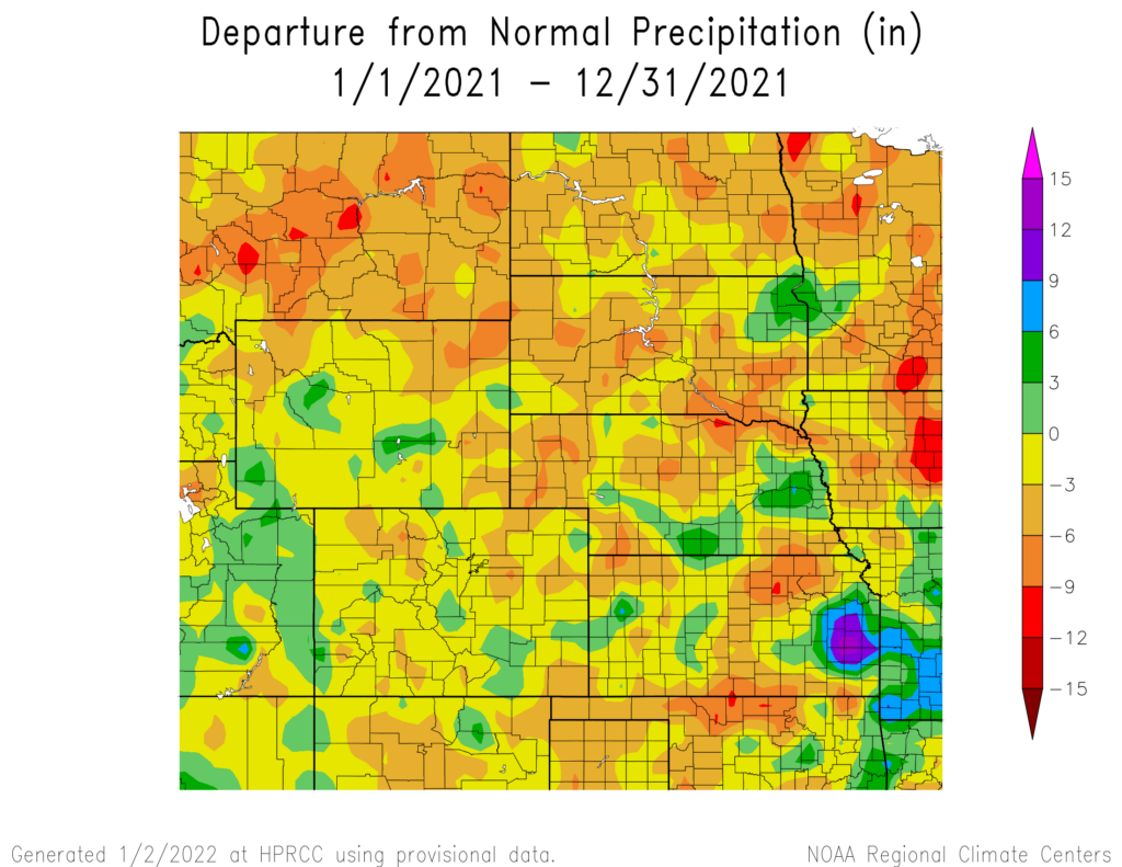
precipitation in inches (bottom) for 2021. These maps are produced
by HPRCC and can be found on the Current Climate Summary Maps
page at: http://hprcc.unl.edu/maps/current
Temperature
Temperatures across the region were above normal for the year, with the northern part of the region being well above normal. The majority of the region experienced departures of 2.0 degrees F (1.1 degrees C) with isolated parts of North Dakota observing departures of above 5.0 degrees F (2.8 degrees C). The year started with above normal temperatures but cooled off dramatically with a historic outbreak of Arctic air that affected the region during the middle of February. Multiple records were broken during the span of several weeks. Outside of cooler temperatures in March and May, the region experienced above normal temperatures throughout the year.
The following locations had notable temperature records during 2021:
• Sisseton, South Dakota: Warmest year on record. The average temperature was 48.0 degrees F (8.9 degrees C), which broke the previous record of 47.1 degrees F (8.4 degrees C), set in 2016 (period of record 1931-2021)
• Bismarck, North Dakota: Also observed the warmest year on record. Average temperatures were 47.2 degrees F (8.4 degrees C), which broke the previous record of 46.5 degrees F (8.1 degrees C) from 2016 (period of record
1886-2021)
• Omaha, Nebraska: Warmest December temperature on record at 74.0 degrees F (23.3 degrees C), December 15 (period of record 1871-2021)
• Bottineau, North Dakota: Lowest temperature on record at -51.0 degrees F (-46.1 degrees C), February 13 (period of record 1893-2021)
• Grand Junction, Colorado: Warmest temperature on record at 107 degrees F (41.7 degrees C), July 9 (period of record 1893-2021)
• Bismarck, North Dakota: Most number of 100.0 degree F (37.8 degrees C) in a single year, 15 days
Drought Conditions
According to the U.S. Drought Monitor, significant improvements to drought conditions were observed throughout the High Plains this past year. At the beginning of 2021, 81 percent of the region was in moderate to exceptional (D1-D4) conditions. The drought was particularly devastating in Colorado, where 28 percent of the state was in D4 conditions and 76 percent of the state experienced extreme drought (D3) at the start of the year.
During the course of the year, conditions deteriorated drastically then rebounded in North Dakota. At the peak of the drought on May 18th, 85 percent of the state experienced D3 conditions and 17 percent of the state was within D4 conditions. The drought caused serious issues for agriculture during the late spring and summer months. At the year’s end, conditions have improved substantially with only 8 percent of the state in D3 conditions. Colorado began
the year in bad shape but gradually improved throughout the year. Despite the improvements to drought conditions, the state observed destructive wildfires in late December which destroyed hundreds of homes north of Denver.
At the end of the year, 65 percent of the region was experiencing D1 to D3 conditions. Although the majority of the region was in drought conditions, the entire region has been without D4 conditions to end the year. Even with the improvements this past year, 88 percent of the region remained in abnormally dry (D0) conditions.

Department of Agriculture (USDA), National Drought Mitigation
Center, U.S. Department of Commerce, and the National Oceanic and
Atmospheric Administration (NOAA). For current Drought Monitor
information, please see: http://droughtmonitor.unl.edu/.
Noteworthy Events
Historic February Cold: Historic cold impacted the region in February. Many areas in the region observed record breaking temperatures and temperature departures exceeding 40 degrees F (22.2 degrees C) below normal occurred
in Nebraska. The extreme cold was most notable due to its duration which lasted for 1-2 weeks. The Southwest Power Pool, which serves the Dakotas, Nebraska, and Kansas, was most impacted with rolling blackouts and requests to residents to conserve energy until temperatures increased.
March Precipitation: A slow-moving storm system brought heavy rain and snow over the southern High Plains. Many areas received over 200 percent of their normal precipitation for the month of March. Numerous daily and monthly records were set, and some locations received more precipitation from this storm than what they would expect for the entire month. While this system caused areas of flooding, road closures, and canceled flights, it did help
to replenish soil moisture and improve drought conditions.
Colorado Mudslides: Localized heavy rains in burn scarred areas led to multiple mudslides along I-70 in Colorado. Starting in late June, multiple mudslides resulted in the closure of the major interstate and traffic delays. July 29th, more than 100 motorists were trapped on the interstate overnight with some taking shelter in a nearby tunnel. This July event closed I-70 for a record 15 days
before debris could be removed to make way for motorists.
December Derecho: On December 15th, a powerful derecho moved across the High Plains and traveled more than 650 miles across the country. Impacts in our region were observed across Colorado, Nebraska, and Kansas. Preceding the storm, daily temperature records were being set all across the region. High winds from the derecho set new daily wind records, created dust storms, and damaged structures and powerlines. Tornadoes also occurred in areas,
Nebraska exceeded their previous December tornado record of 5 after 27 tornadoes were confirmed across the state.
Drought Across the Region: Drought conditions persisted throughout the year with impacts seen across the region. Pastures and rangeland were in poor to very poor conditions, with poor water quality and forage, resulting in increased
cattle sales. Extreme heat resulted in earlier than average maturation and harvest for crops as well as pest issues as a result of grasshoppers thriving in warm conditions. Wildlife and pollinators were also impacted with lower than average pronghorn fawn survival rates and dwindling beehive sizes.
Wildfires: Warm and dry conditions resulted in multiple wildfires across the region this year, the most severe in Wyoming and Montana. Smoke from the wildfires could be seen across the High Plains with hazy skies.
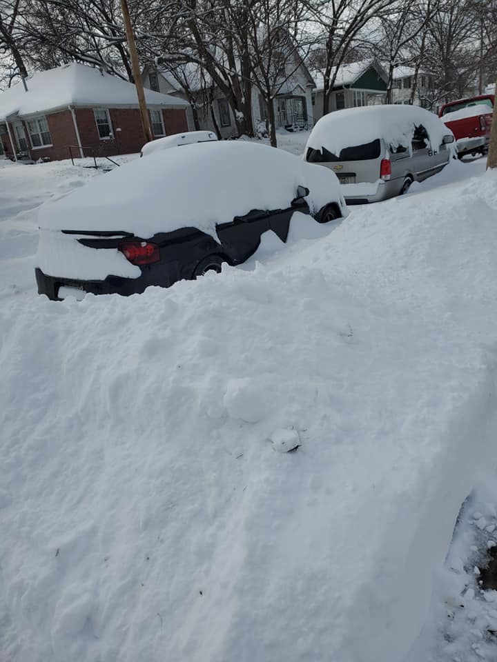
Snow in Lincoln, NE. Photo courtesy Heleena Pettee, High
Plains Regional Climate Center.

Flooding at Holmes Lake in Lincoln, NE. Photo courtesy Rezaul Mahmood, High Plains Regional Climate Center.

Drought stressed crops in KS. Photo courtesy Chip Redmond

Burn scarred area along Pourde River in CO. Photo courtesy Dannele Peck
Station Summaries: By the Numbers


