April 2023 Climate Summary
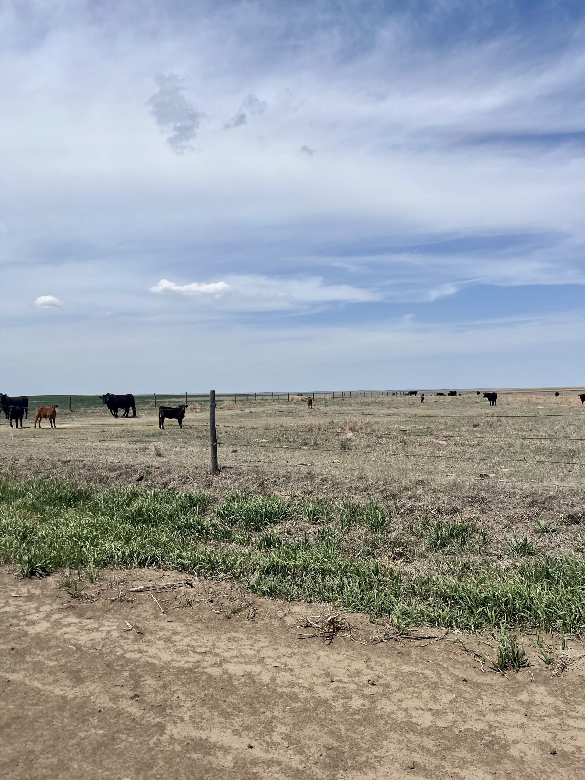
Cattle in a struggling Western Kansas Pasture, Photo Courtesy of Gannon Rush
Regional Breakdown
The northern parts of the High Plains continued to deal with the brutal winter, while the southern portions were dry once again. Both parts of the region are dealing with issues related to their ends of the extremes.
Snow continued to pile up in the Dakotas and Wyoming, with numerous impacts. Hunting permits for antelope and deer were slashed in Wyoming this fall as a result of the winter. The Wyoming Game and Fish Department observed the excessive snowfall reduced both populations and has cut the permit numbers in an effort to help manage the populace. In North Dakota, a large number of dead deer were reported around the state, with over 100 reported in the Jamestown area alone. The rapid snowmelt in the middle of the month further exacerbated the issues, with flooding along the Red River and the Big Sioux. While in South Dakota, the heavy snow caused homes to explode due to the excessive weight.
In the southern Plains, drought-related issues continued to plague the population. Several significant wildfires broke out in Nebraska due to the dry conditions. The state has implemented a burn ban to help reduce the number of fires. Kansas agricultural producers are preparing for another year of drought, with farmers scrambling to find food sources for their already culled herds.


Precipitation and Water Resources
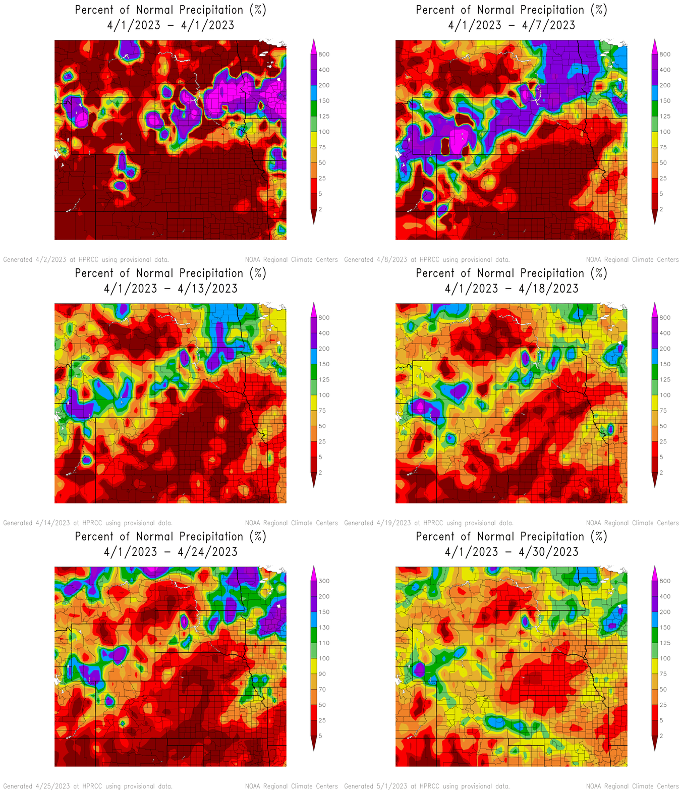
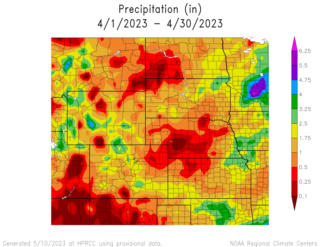
April precipitation was below-normal for much of the region, with Nebraska very dry. The majority of the state was below 25 percent of their normal precipitation, leading to multiple locations ranking in the top 10 driest. Southwestern Kansas finally received some meaningful precipitation, however, not nearly enough to help improve the dire drought situation.
North Platte, Nebraska was arguably the driest location in the region, with only 0.04 inches (1.02 mm) of precipitation. This tied with 1928 for the driest April on record. Nearby Grand Island only observed 0.15 inches (3.81 mm), ranking 3rd driest. Other locations in the state ranking in the top 10 driest include Chadron, Lincoln, and Norfolk.
The significant snowfall that has impacted the Dakotas and Wyoming continued into April. Parts of Wyoming saw over 30 inches (76.2 cm) of snow, leading to numerous records. The small town of Atlantic City observed a whopping 48.8 inches (123.95 cm), the most in the state. The Dakotas received over 20 inches (50.8 cm) in some places. With such high totals continuing into April, many locations are likely to have recorded their snowiest year on record.
According to the United States Army Corps of Engineers, runoff for this calendar year is projected to be slightly above-normal despite the drought conditions. Streamflow is well below-normal across much of the southern Plains, while rapid snowmelt has led streams to be well above-normal in the Dakotas.

Temperatures
Winter does not seem to want to end, with cooler temperatures dominating the northern and western parts of the region. Average temperatures were still below freezing across North Dakota and Wyoming, with some locations recording their coldest April on record.
Temperatures have been cooler for western Wyoming since the beginning of the year, with some locations 10 degrees F (5.6 degrees C) below normal through the end of April. Multiple locations including Tower Falls and Pavillion recorded their coldest month on record. Old Faithful in Yellowstone National Park observed a chilly average temperature of 25.9 degrees F (-3.4 degrees C) this month.
Just like Wyoming, North Dakota continued to be cooler into April. Despite having temperatures over 10 degrees F (5.6 degrees C) below normal, only three locations in the state ranked as the coldest April on record. Most notably, the town of Mayville has records dating to 1895 and observed an average temperature of 29.8 degrees F (-1.2 degrees C) to rank coldest on record. Both Moffit and Carrington also recorded their coldest month.
A heatwave impacted the lower part of the region in the middle of April, leading to temperatures skyrocketing well above 90 degrees F (32.2 degrees C). Atwood, Kansas was the warmest, with a high of 97 degrees F (36.1 degrees C) on the 13th. Hundreds of daily temperature records were broken from the 11th to the 13th as a result of this early heatwave.
Drought Conditions
For the second month in a row, drought conditions improved in the Dakotas while degrading in the southern plains. Central Kansas and the front range of Colorado experienced up to a three-class degradation in April alone. Overall, there was a 6 percent decrease in D0 to D4 (abnormally dry to exceptional drought conditions).
Rapid snowmelt after well-above-normal temperatures caused North Dakota to observe a 40 percent decrease in D0 to D4. Soil moisture greatly improved, while some minor flooding is taking place in the state. While some beneficial precipitation occurred in southwestern Kansas late in the month, the majority of the state has experienced a poor spring for precipitation. The central part of the state observed a multi-class degradation, with a 10 percent increase in D4. Elsewhere in the region, other localized improvements and degradation were observed.

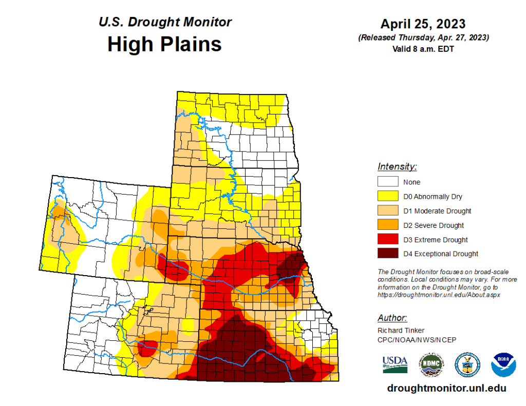
Department of Agriculture (USDA), National Drought Mitigation
Center, U.S. Department of Commerce, and the National Oceanic and
Atmospheric Administration (NOAA). For current Drought Monitor
information, please see: http://droughtmonitor.unl.edu/
Climate Outlooks
According to the Climate Prediction Center, La Niña conditions have ended and transitioned to ENSO-neutral. The final La Niña advisory was
issued on March 9th. For more information, visit https://www.cpc.ncep.noaa.gov/products/analysis_monitoring/lanina/enso_evolution-status-fcsts-web.pdf
The National Weather Service’s long-range flood outlook indicates increased chances of Major Flooding in central South Dakota. According to the National Interagency Fire Center (NIFC), fire potential will be limited across the region through August.
The seasonal temperature and precipitation outlook presented below combine the effects of long-term trends, soil moisture, and when applicable, the El Niño Southern Oscillation (ENSO). To learn more about these outlooks, please visit http://www.cpc.ncep.noaa.gov.
Temperature
The three-month temperature outlook shows an increased chance of above-normal temperatures across the southern and eastern United States. Increased chances of above-normal temperatures are present in Colorado and Kansas.

Precipitation
The outlook for the next three months indicates below-normal precipitation across the southwestern and northwestern United States, while above-normal precipitation is favored for the Southeast. The High Plains region has equal chances of precipitation.

Drought
The U.S Seasonal Drought Outlook released on April 30th indicates improvements to drought conditions in the western portions of the region. Drought conditions will likely be introduced across eastern Kansas.

Station Summaries: By the Number


Download PDF Below
