May 2022 Climate Summary
Struggling Kansas Winter Wheat, Photo Courtesy of Gerry Tally
Drought Finally Began to Improve
May ended on a high note for many places in the High Plains, with much-needed precipitation arriving.
Another derecho impacted the region on the 12th of May, with 67 reports of 75+ mph (121 km/h). This surpassed the event on December 15th of last year and broke the record for the most significant wind gusts in one day. Notable impacts include a 105 mph (169 km/h) wind gust recorded near Tripp, South Dakota and 13 tornadoes in the state. Unfortunately, there were three deaths from this event.
On the same day, a very rare haboob crossed through Nebraska and South Dakota. Haboobs are walls of dust in front of thunderstorms resulting from high downdraft speeds. This led to low visibility and near blackout conditions. A state of emergency was declared in South Dakota to help those impacted by the storms. Despite temperatures near normal for the region, an unseasonable heat wave led to many broken daily records. Between May 8th and 14th, 267 high maximum temperature and 453 high minimum temperature records were broken, for a total of 720 records (minimum of 30 years of data). Every state recorded at least one record, with Colorado, Kansas, and Nebraska primarily impacted

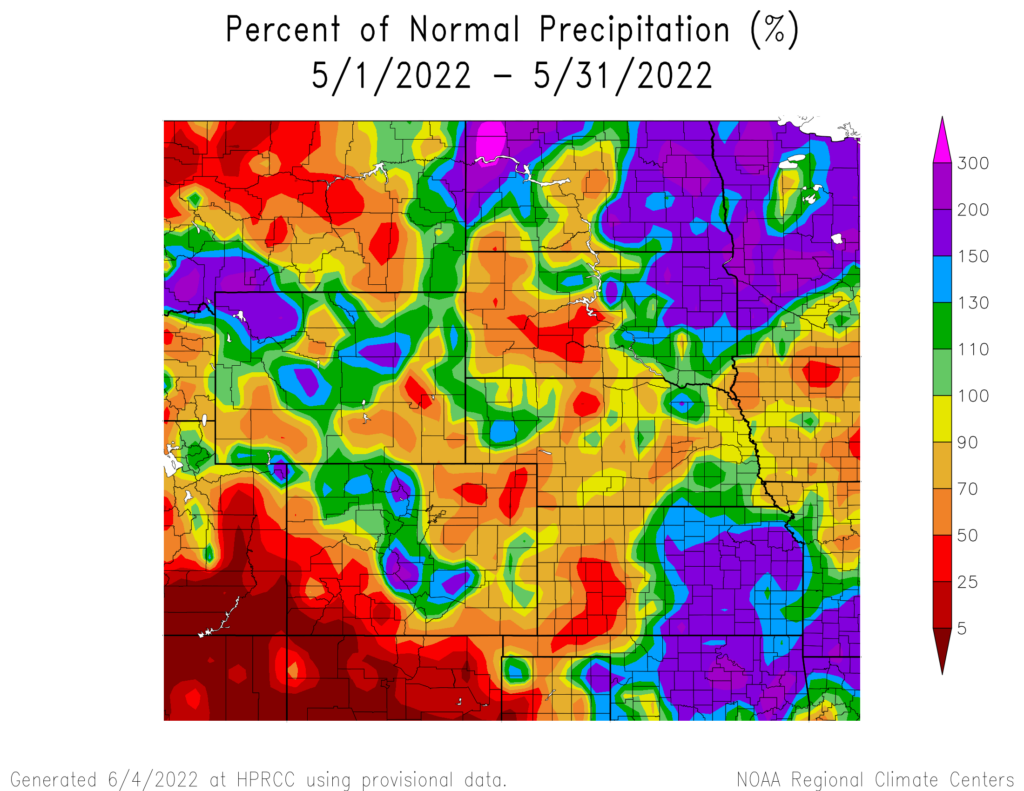
produced by the High Plains Regional Climate Center and are available at: http://hprcc.unl.edu/maps/current .
Precipitation
Precipitation for the region was mixed. Some parts of the region such as eastern Kansas were well above-normal, while areas such as southwest South Dakota were well below-normal. Several locations in Kansas, North Dakota, and South Dakota observed their top 10 wettest months on record.
Eastern Kansas was extremely wet in May, with multiple rounds of storms occurring. Wichita observed its 2nd wettest month on record, with 12.95 inches (32.89 cm) of precipitation. Topeka observed their 3rd wettest, and Salina recorded their 4th wettest month on record, with 11.68 and 8.72 inches (29.67 cm and 22.15 cm), respectively. In North Dakota, Williston and Grand Forks observed the 3rd and 5th wettest on record. Aberdeen, South Dakota also ranked in the top 10 wettest. Back-to-back months of above-normal precipitation have led to serious flooding issues along the Red River in North Dakota. Near the Canadian border, river levels crested at 52.27 feet (15.93 meters) on May 8th. This was well above the flood stage of 39 feet (11.89 meters) for that location. The flooding and heavy precipitation have led to significant issues for agriculture, with planting well behind the normal schedule.
Overall, severe weather was less active than normal throughout the region, except for South Dakota. During May, there were 108 more than the average (2002-2022) severe thunderstorm and tornado warnings issued in South Dakota. In contrast, Kansas was 155 warnings below the average for May. There were numerous reports of large hail this month, but a storm on the 29th was particularly dangerous. In central Nebraska, a storm over Loup County had several reports of 5-inch (12.7 cm) hail with unconfirmed reports of hailstones in the 6-inch (15.24 cm) range.
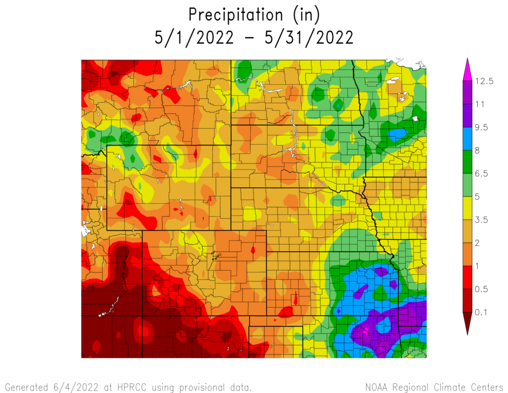
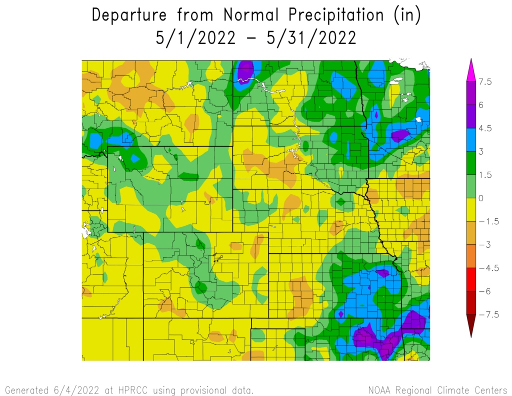
precipitation in inches (bottom) for May 2022. These maps are produced by HPRCC and can be found on the Current Climate Summary
Maps page at: http://hprcc.unl.edu/maps/current.
Snowpack Update
Upper Missouri River Basin mountains began to melt in May. According to the U.S. Army Corps of Engineers, as of May 30, Snow Water Equivalent (SWE) above Fort Peck Reservoir is currently at 8.1 inches (20.57 cm) which is 60% of the average (1981-2010). The reach between Fort Peck and Garrison Reservoirs is currently 9.0 inches (22.86 cm) which is 67% of the average (1981-2010). SWE was near or above median in most Wyoming basins. In Colorado, SWE was nearly melted in the southwest.
Temperatures
Temperatures for the month of May were near-normal throughout the region, with pockets of below-normal observed in Wyoming. Despite the near-normal temperatures, there were large swings present during the month. Hundreds of daily high and low temperatures were broken during the heat wave in Mid-May. Every state in the region broke either a high maximum temperature or high minimum temperature. On the opposite end of the spectrum, Wyoming broke 73 low maximum or low minimum temperature records during this period.
Below-normal temperatures in Wyoming led to one location ranking in the top 10 coldest on record. The city of Casper observed their 8th coldest month on record, with an average temperature of 48.3 degrees F (9.1 degrees C). Several other locations in Wyoming came close to being in the top 10 due to the cooler temperatures this month.
The near normal to cooler than normal temperatures have also been beneficial in the prevention of intensifying drought conditions. Many areas in eastern Wyoming and southwestern South Dakota observed well below normal precipitation this month, however, the temperatures helped prevent a significant expansion of drought conditions.
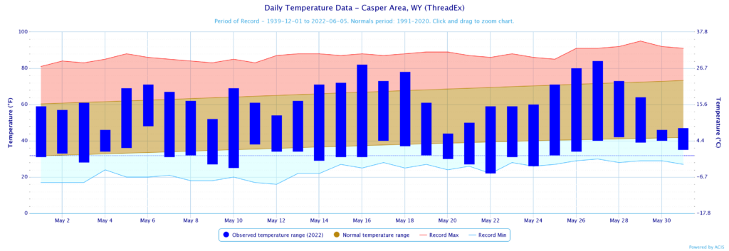
normals values in Casper, Wyoming.
Drought Conditions
Across the region, drought conditions improved in May as a result of beneficial precipitation. The High Plains region observed a 14 percent decrease in severe to exceptional (D2-D4) drought, there was also a 10 percent increase in areas that are not in any drought or abnormally dry conditions.
After back-to-back months of well above-normal precipitation, North Dakota is now drought-free. Currently, only 12 percent of the state is in abnormally dry (D0) conditions. Conditions in South Dakota and Wyoming also improved significantly, with extreme drought (D3) and D2 reduced by 30 and 36 percent, respectively. While eastern Kansas is nearly free of drought, the western part of the state observed a 12 percent increase in D3 and D4 conditions. Colorado also recorded an 11 percent increase in D3-D4 conditions. Elsewhere in the region, other improvements and degradation were observed. According to the Climate Prediction Center’s U.S. Monthly Drought Outlook for June, improvements in drought conditions are likely across South Dakota, northern Wyoming, eastern Nebraska, and central Kansas.

Department of Agriculture (USDA), National Drought Mitigation
Center, U.S. Department of Commerce, and the National Oceanic and
Atmospheric Administration (NOAA). For current Drought Monitor
information, please see: http://droughtmonitor.unl.edu/
Climate Outlooks
According to the Climate Prediction Center, La Niña conditions are likely to continue into the summer. A La Niña advisory is currently in effect. For more information, visit https://www.cpc.ncep.noaa.gov/products/analysis_monitoring/lanina/enso_evolution-status-fcsts-web.pdf
The National Weather Service’s long-range flood outlook through August indicates a high chance of minor flooding across eastern South Dakota and the lower basin in June. This will decrease over the next three months. There is a high risk of Major Flooding in northeastern South Dakota. According to the National Interagency Fire Center (NIFC), fire potential will be limited in June but expand across the entire region in July and August.
The seasonal temperature and precipitation outlook presented below combine the effects of long-term trends, soil moisture, and when applicable, the El Niño Southern Oscillation cycle (ENSO). To learn more about these outlooks, please visit http://www.cpc.ncep.noaa.gov.
Temperature
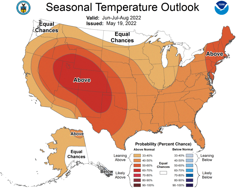
The three-month temperature outlook shows an increased chance of above-normal temperatures across the majority of the United States. In the High Plains, North Dakota has equal chances of above-, below-, and near-normal temperatures. Meanwhile, the rest of the region has increased chances of above-normal temperatures with Colorado heavily favored.
Precipitation
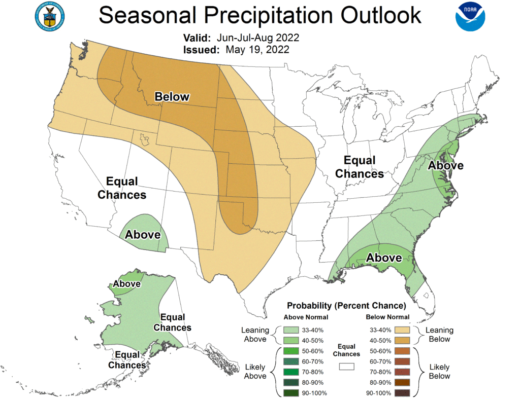
The outlook for the next three months indicates below-normal precipitation across the majority of the western United States. Across the High Plains there are equal chances of above-, below-, and near-normal precipitation in eastern North Dakota and northeastern South Dakota. The rest of the region has increased chances of below-normal precipitation.
Drought
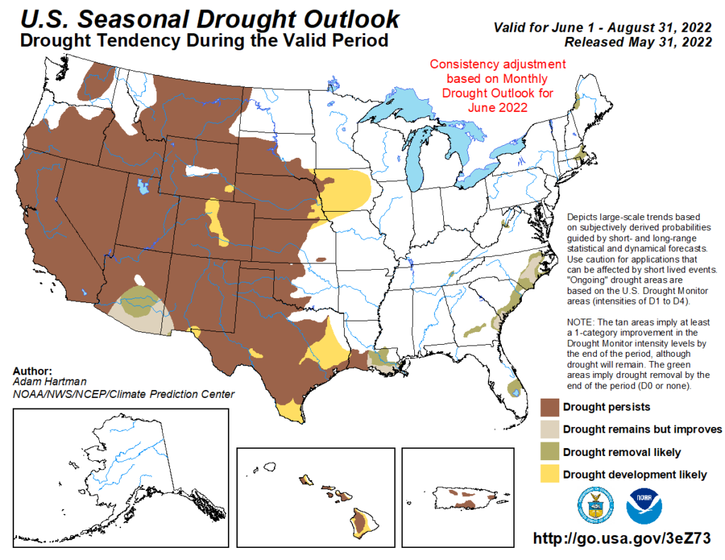
The U.S Seasonal Drought Outlook released on May 31st indicates drought conditions are expected to remain with development likely in eastern Nebraska, central Colorado, and eastern Wyoming.
Station Summaries: By the Number


Download PDF below
