January 2022 Climate Summary
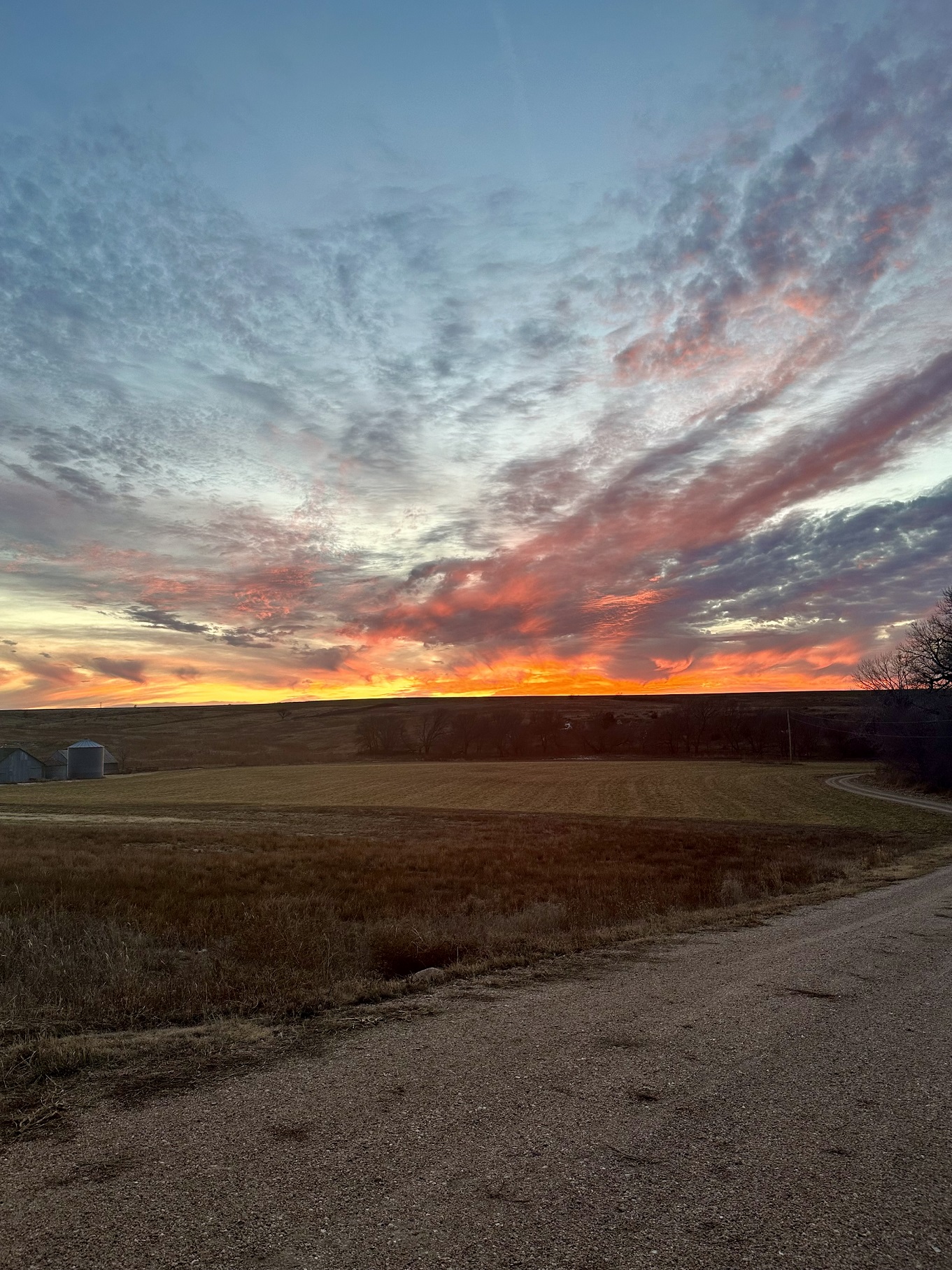
Jackson Hole, Wyoming, Photo Courtesy of Gavin Rush
Cold Start to the New Year
2022 began on a very cold note for the High Plains. A brutal cold front pushed through the region on the first few days of the month, with many stations recording their coldest day during the period. Temperatures plummeted below zero throughout the region, with North Dakota observing the bitterest of temperatures. Grand Forks observed a temperature of -37 degrees F (-38 degrees C) on the first, while many other stations in North Dakota experienced temperatures of -30 degrees F (-34 degrees C) or below. These frigid temperatures would linger throughout the month, with some stations having average temperatures below zero for the month.
In contrast to these cold temperatures, the middle of the month was unseasonably warm in the southern High Plains. Multiple states observed daily temperature records broken, with departures of up to 30 degrees F (17 degrees C) above normal for this time of the year. The highest temperature recorded during this period was in southwest
Kansas at Montezuma. Temperatures reached 73 degrees F (23 degrees C) on the 19th, which broke the dailytemperatur e record. Castle Rock, Colorado observed a high temperature of 72 degrees F (22 degrees C) on the 8th and broke the record for warmest day in January on record for the station. The daily average temperature on the 8th was 54 degrees (12.2 degrees C), which surpassed the previous record of 53.5 degrees F (11.9 degrees C).
Late in the month, a heavy snowstorm impacted eastern Colorado and western Kansas. A narrow swath of significant snowfall occurred on the 25th, with areas receiving 15 to 17 inches (38 cm to 43 cm). An isolated pocket along the Colorado and Kansas border received 20 or more inches (51 cm) of snow. The highest amounts were recorded near Mount Sunflower in Kansas, where 27 inches (69 cm) fell in 24 hours.
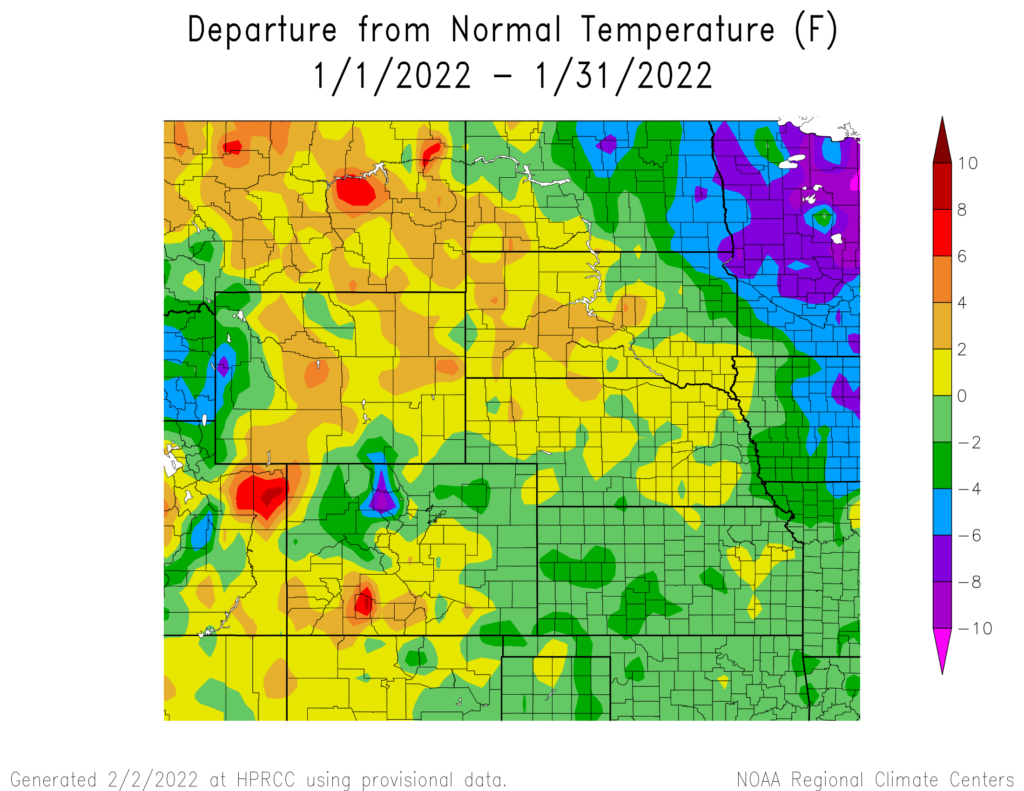

produced by the High Plains Regional Climate Center and are available at: http://hprcc.unl.edu/maps/current
Precipitation
The majority of the High Plains was dry for the month of January. Large portions of Kansas, Nebraska, and South Dakota observed well below normal precipitation. Several snowstorms across southeastern Wyoming, northwestern Kansas, western Nebraska, and eastern Colorado led to above normal precipitation for the area.
Two locations ranked among the driest for January, while several snowstorms led to locations ranking among the snowiest and wettest (see page 6 for December monthly rankings). Dryness was most prevalent across eastern Nebraska, where Norfolk experienced the driest January on record with 0.04 inches (1 mm) of precipitation. In western Colorado, Grand Junction observed the 10th driest month on record, with only 0.14 inches (3.56 mm) of precipitation. Contrary to this, multiple snowstorms led to the 9th wettest January on record for Casper, Wyoming, with 0.90 inches (22.86 mm) of precipitation.
The snowstorm on the 25th of the month helped several locations break snowfall records. In Sharon Springs, Kansas, 21 inches (53.34 cm) of snow fell, surpassing the one-day snowfall record for the station. The large snow amounts helped the station record its snowiest January, with 31 inches (78.74 cm) of snow. This easily passed the previous record of 15.2 inches (38.61 mm), set in 2001. Nearby Dodge City observed their 7th snowiest January on record, with 11.7 inches (29.72 cm) of snow falling. In eastern Colorado, Burlington recorded its snowiest January on record after receiving 19 inches (48.26 mm) during this same storm. Cheyenne, Wyoming also observed their 8th snowiest January on record, with 14.3 inches (36.32 mm) of snow falling during the month.

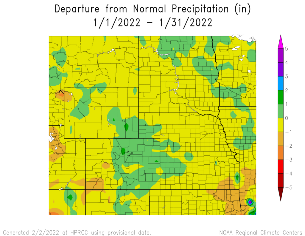
precipitation in inches (bottom) for January 2022. These maps are produced by HPRCC and can be found on the Current Climate Summary
Maps page at: http://hprcc.unl.edu/maps/current.
Snowpack Update
Snowpack for this winter season remains just below normal for the Upper Missouri River Basin mountains. According to the U.S. Army Corps of Engineers, as of December 28th, Snow Water Equivalent (SWE) above Fort Peck Reservoir is currently at 9.1 inches (231.14 mm) which is 87% of the average (1981-2010). The reach between Fort Peck and Garrison Reservoirs is currently 7.7 inches (195.58 mm) which are 86% of the average (1981-2010). In the Plains, areas with snow on the ground at the end of January were observed in North Dakota and a portion of South Dakota. Meanwhile, warm and dry conditions resulted in snow-free areas across the remainder of the plains.
Temperatures
Temperatures for the region varied throughout the month, with 2022 starting cold then transitioning to warmer than normal in the middle of the month. As a result of the fluctuating temperatures, departures in the region remained near normal. Wyoming as well portions of the Dakotas, Nebraska, and Colorado observed temperatures up to 4 degrees F (7 degrees C) above normal while the remainder of the region observed temperatures up to 4 degrees F (7 degrees C) below normal. A small area in the Rockies did observe temperatures up to 8 degrees F (14 degrees C) below normal. Despite below normal snowfall in parts of Colorado, these cooler temperatures allowed ski resorts to maintain their base snow depths.
With temperatures near normal, no locations in our region ranked in the top 10 coldest or warmest January on record, however, some areas did see new daily records set throughout the month. With a cold start to the month, Grand Forks, North Dakota set a new record low for New Year’s Day with a temperature of –37 degrees F (previous record of –35 degrees F in 1885). As the middle of the month transitioned to unseasonably warm, Hastings, Nebraska set a new daily high of 66 degrees F (19 degrees C) on the 18th, surpassing the previous record of 65 degrees F (18 degrees C) set in 1951. Sioux Falls, South Dakota also
tied their record high on the 18th with a temperature of 52 degrees F (11 degrees C) (tie with 1944+).

and normals values in Grand Forks, North Dakota.
Drought Conditions
Dryness across the eastern part of the region led to the spread of drought and abnormally dry conditions. Meanwhile, beneficial precipitation improved conditions in the tri-state area of Colorado, Nebraska, and Wyoming. The region has remained free of exceptional drought (D4) conditions since November of 2021.
Drought continued to expand across Kansas during January, with nearly 60 percent of the state now under moderate drought (D1) to D4 conditions. Western North and South Dakota both experienced an increase of severe drought (D2), with conditions rising 5 and 8 percent, respectively. In the U.S. Drought Monitor, extreme drought (D3) was removed from Nebraska and reduced in Colorado and Wyoming. D1 to D4 conditions were reduced 7 percent in Colorado after the western part of the state experienced much-needed precipitation. Despite the improvements in Colorado and Wyoming, both states remained in abnormally dry (D0) to D4 conditions. Throughout the rest of the region, other improvements and degradations were observed. According to the Climate Prediction Center’s U.S. Monthly Drought Outlook for January, drought improvement is likely in western Wyoming, while drought development is likely in eastern Kansas, central Nebraska, and southern South Dakota.

The U.S. Drought Monitor is produced as a joint effort of the U.S.
Department of Agriculture (USDA), National Drought Mitigation
Center, U.S. Department of Commerce, and the National Oceanic and
Atmospheric Administration (NOAA). For current Drought Monitor
information, please see: http://droughtmonitor.unl.edu/
Climate Outlooks
According to the Climate Prediction Center, La Niña conditions persist and are likely to continue throughout the winter season. A La Niña advisory is in effect. For more information, visit https://www.cpc.ncep.noaa.gov/products/analysis_
monitoring/lanina/enso_evolution-status-fcsts-web.pdf
The National Weather Service’s long-range flood outlook through April indicates an increased chance of minor flooding in the eastern portion of the Dakotas and the lower basin. Chances of flooding remain above 60% with some areas greater than 80%. This chance will decrease slightly as the year progresses but remain elevated in the eastern Dakotas. According to the National Interagency Fire Center (NIFC), in the High Plains, the majority of Kansas and Eastern Colorado have above-normal wildland fire potential and is expected to remain through March. The seasonal temperature and precipitation outlooks presented below combine the effects of long-term trends, soil moisture, and when applicable, the El Niño Southern Oscillation cycle (ENSO). To learn more about these outlooks, please visit http://www.cpc.ncep.noaa.gov.
Temperature
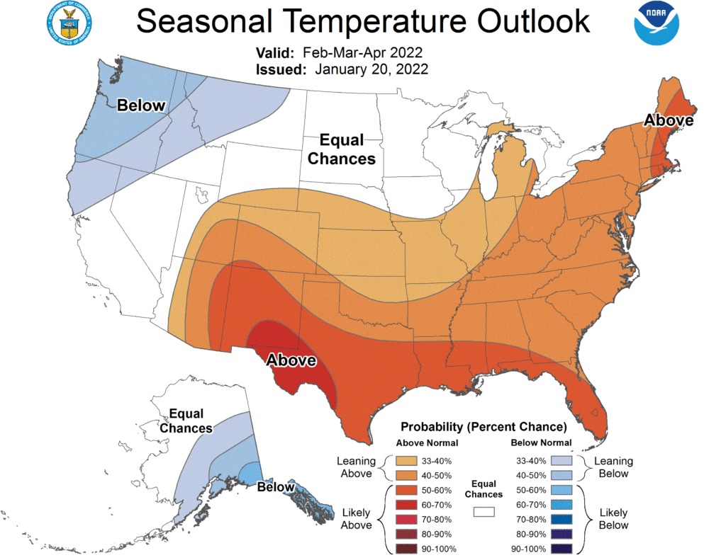
The three-month temperature outlook shows an increased chance of above-normal temperatures across the east coast, southern plains, and parts of the southwest. The highest chances of below-normal temperatures can be observed in the Northwestern United States. In the High Plains, most of the northern parts of the region have equal chances of above-, below-, and near-normal temperatures, while the southern parts have increased chances of above-normal temperatures.
Precipitation
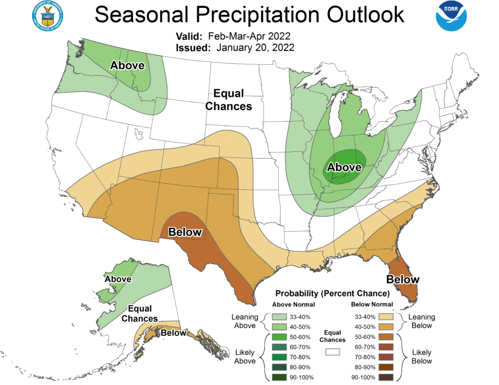
The outlook for the next three months indicates below-normal precipitation across the Southwest and Southeast of the United States. In the Midwest and Northwest, there are increased chances of above-normal precipitation. Across the High Plains there are equal chances of above-, below-, and near normal precipitation, aside from Colorado and the western parts of Kansas and Nebraska which have increased chances of above-normal precipitation.
Drought
The U.S Seasonal Drought Outlook released on January 20th indicates drought conditions are expected to persist across the Southwest and western High Plains over the next three months. Drought conditions are expected to remain but show minor improvements in the Northwest and Northeast, with some areas likely to observe drought removal. Drought development is likely in the southern United States and the central High Plains.

Above: The three-month temperature probability outlook (top), the
three-month precipitation probability outlook (middle), and the U.S.
Seasonal Drought Outlook (bottom). For more information on these
outlooks, produced by the Climate Prediction Center, see:
http://www.cpc.ncep.noaa.gov
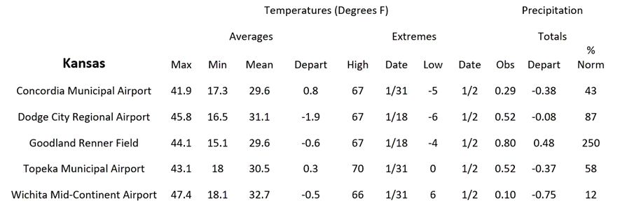
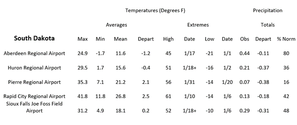
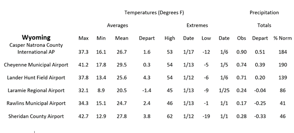
Station Summaries: By the Numbers



Download PDF below
