

April 2025 Climate Summary
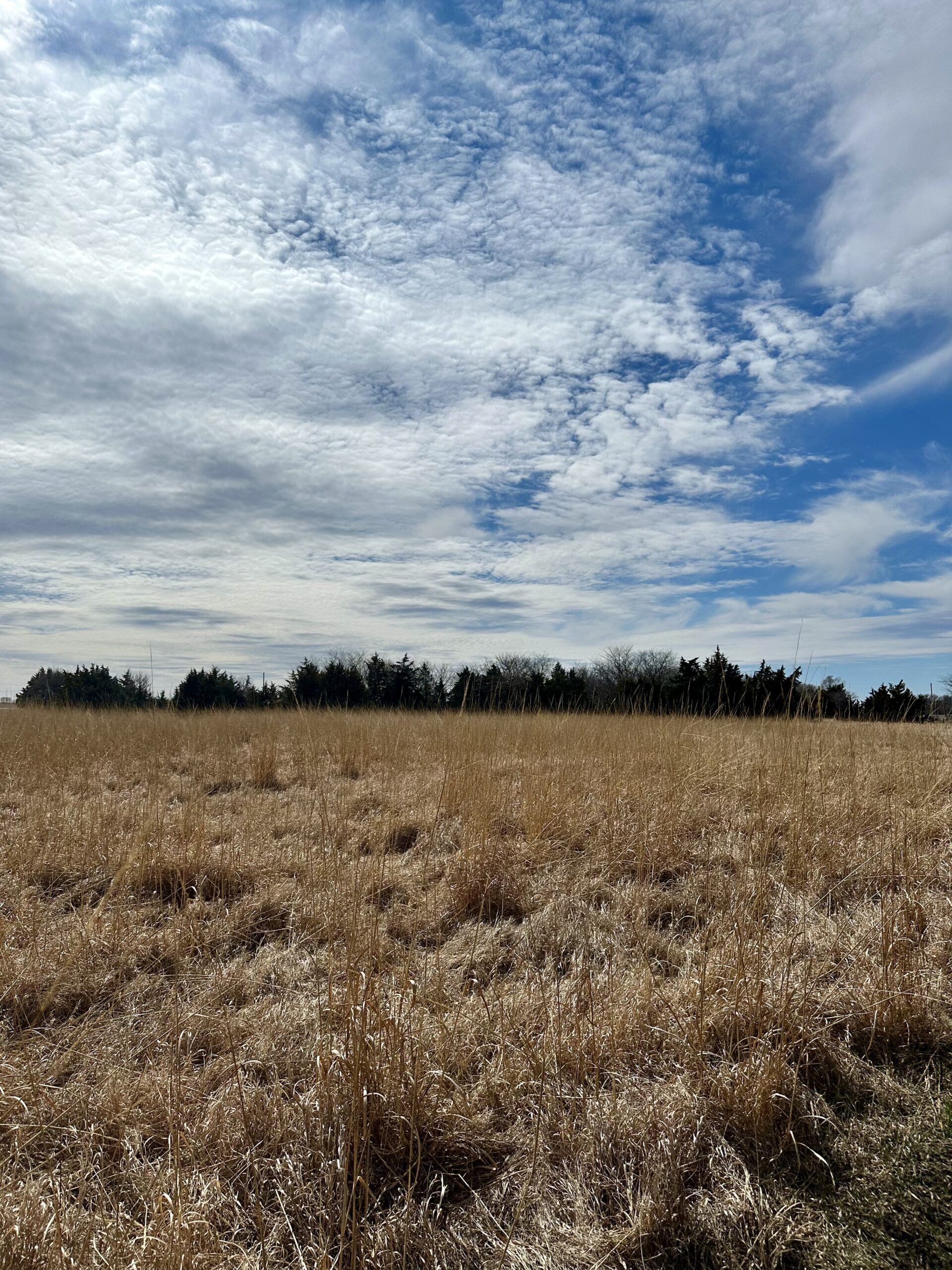
Struggling pasture in central Nebraska, Photo Courtesy of Gannon Rush
Regional Breakdown
April marked the return of severe weather, with several prominent storms striking parts of Colorado, Kansas, and Nebraska. Drought has also taken its toll, with agriculture struggling in the region. To top it all off, nearly three feet (91.44 cm) of snow fell in parts of Wyoming.
Severe weather took off midway through the month, with a particularly dangerous round of storms on the 17th in eastern Nebraska. The town of Fremont was pummeled by four-inch (10.16 cm) hail driven by wind gusts exceeding 80 miles per hour (129 km/h). Siding was shredded on homes, while windows were shattered by the large hailstones. Not long after this, the same storm produced an EF-3 tornado with 140 mile-per-hour (225 km/h) winds that narrowly missed the northern side of Omaha. Another round struck on the 28th, with two nasty storms forming. One hit the Manhattan, Kansas area and was nearly stationary. Heavy rainfall occurred and hail shredded local farms, with a nearby strawberry farm extensively damaged. In the sandhills of Nebraska, a cyclic supercell produced more than a half dozen tornadoes. One of which would grow to 1.25 miles (2.01 km) wide near Hyannis. Thankfully, it would not cause serious damage, but it was in record territory. This would be the widest tornado ever surveyed by the National Weather Service (NWS) in North Platte. It was also only the 7th tornado on record to exceed a mile wide (1.61 km) in Nebraska, which is very surprising considering the prevalence of tornadoes in the state.
At the end of the month, agricultural conditions were struggling due to the long-term dryness in places. Over 25 percent of winter wheat was rated as poor to very poor in Colorado, Nebraska, and South Dakota. Topsoil moisture was also low, with over 60 percent rated as short to very short in those three states. Subsoil moisture was even worse, with many places heavily reliant on good rains in the coming months.
Precipitation and Water Resources
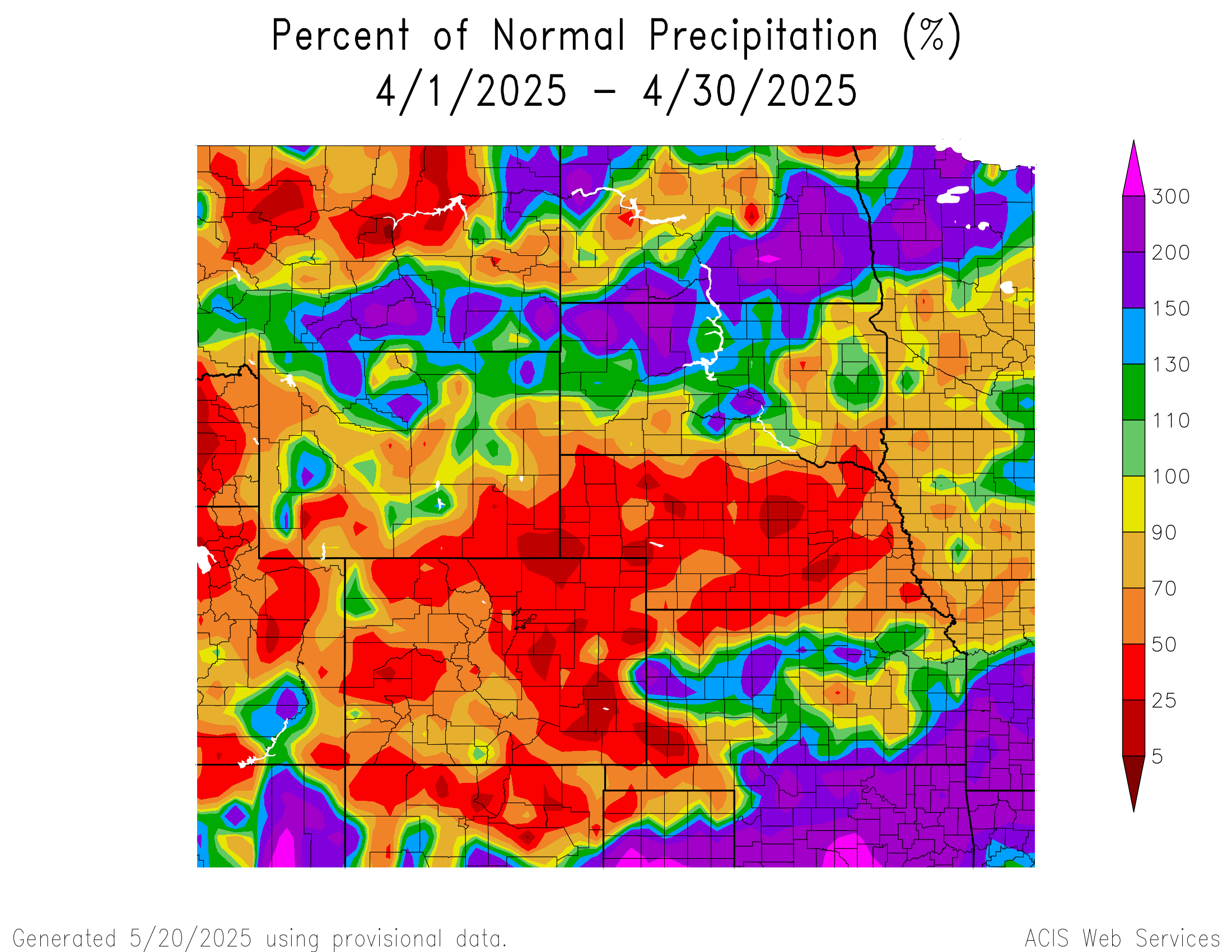
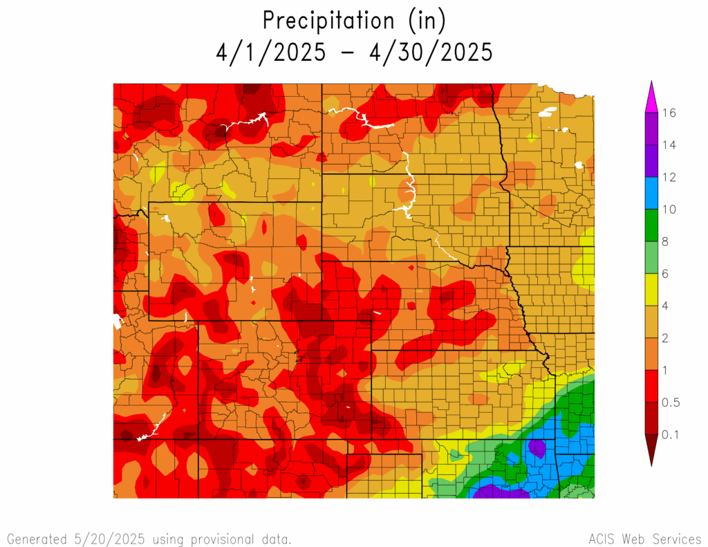
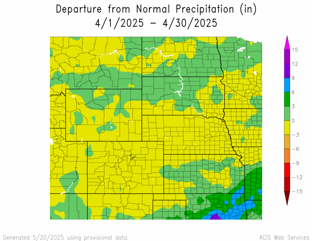
Precipitation was hard to come by in the central High Plains, with large areas receiving less than an inch (2.54 cm) in April. With drought conditions present in these areas, missing out on precipitation during the wettest time of the year is concerning. Contrary to this, locations in extreme southeastern Kansas reported over 10 inches (25.4 cm).
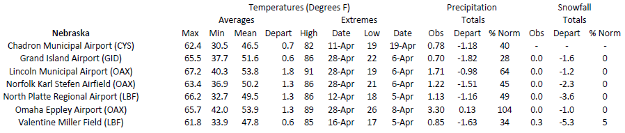
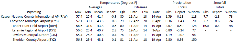
Precipitation was below 50 percent along the Front Range and the majority of Nebraska this month. Several upper elevation stations west of Fort Collins recorded their driest month, while Akron ranked 2nd driest to the east. The southeastern corner of Wyoming was also exceptionally dry, with Cheyenne ranking 7th driest. Nearby locations that recorded less than 0.40 inches (10.16 mm) of precipitation included Wheatland, Torrington, and Bosler. Across the border in Nebraska, Scottsbluff observed 0.44 inches (11.18 mm) and was just outside the top 10 driest. The central part of the state was dry as well, with less than 0.70 inches (17.78 mm) in Grand Island and Hastings. Ord was even less fortunate, with only 0.38 inches (9.65 mm) falling to rank 8th driest. Despite this, drought conditions only changed marginally this month.
Southeastern Kansas was the exact opposite this month, with almost too much rain. Over 10 inches (25.4 cm) fell in a swath from Coffeyville to Pittsburg, with some flooding occurring late in the month. Within the city of Coffeyville, a Community Collaborative Rain, Hail, and Snow Network (CoCoRaHS) observer reported a whopping 14.84 inches (37.69 cm) of rain. This ranks as the third-highest monthly total for April in Kansas. Just to the northeast, Altamont observed 13.63 inches (34.62 cm) and over 11 inches (27.94 cm) fell in the Pittsburg area. Elsewhere in Kansas, Natoma recorded their wettest April with 6.26 inches (15.9 cm) of rain.
Streamflow at the end of April was in decent shape for the region, except for the southern portions. River gauges in the drought-stricken areas of Kansas and Nebraska are at much below normal to record low flows.
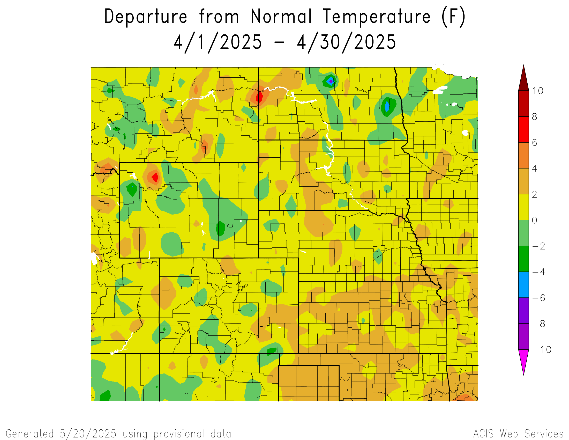
Temperatures
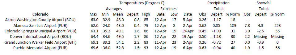
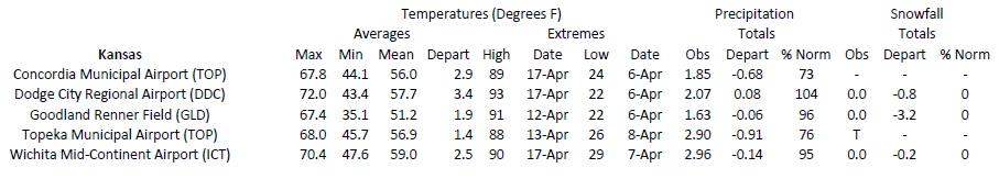
Temperatures were near to slightly above normal across the region this month. Kansas was the warmest, with a few areas 4 to 6 degrees F (2.2 to 3.3 degrees C) above normal. Overall, it was a rather quiet month for temperatures, with no locations ranking in the top 10.
Despite the near-normal temperatures this month, several days were rather warm. Medicine Lodge, Kansas reached 102 degrees F (38.9 degrees C) on the 17th. Not only was this an early occurrence of 100 degrees F (37.8 degrees C) in Kansas, but it was also the second warmest temperature recorded in the state for that early in the year. To the west in the Colorado plains, highs reached 97 degrees F (36.1 degrees C) in the Lamar area just a few days earlier on the 12th. Another round of heat swept across Nebraska on the 28th, with temperatures reaching 93 degrees F (33.9 degrees C) in Tekamah and 91 degrees F (32.8 degrees C) in Lincoln. Between all the rounds of heat, an impressive number of high-temperature records were tied or broken. Colorado led the way with 15 stations recording or tying their warmest temperature in April, while Kansas had four and Wyoming had two.
Drought Conditions
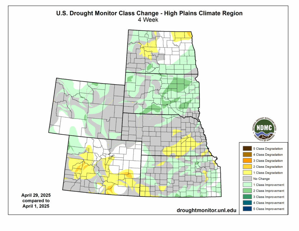
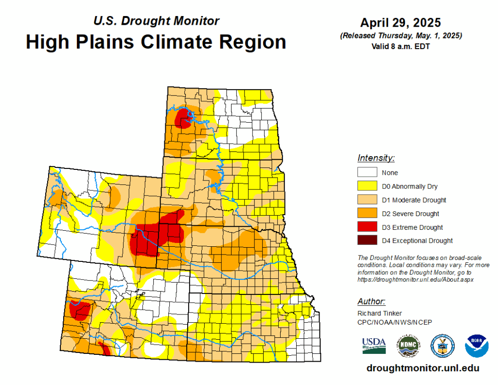
Despite the central part of the region missing out on most of the rain, drought conditions did not degrade considerably. The areas that did receive precipitation such as South Dakota and Wyoming improved slightly. Overall, the percentage of the region in D0 to D4 (abnormally dry to exceptional drought conditions) decreased by over nine percent this month.
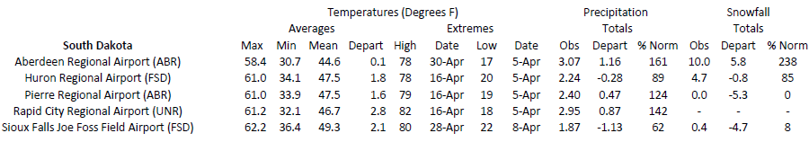
South Dakota was the big winner this month, with D2 (severe drought) reduced by 48 percent across the state after over four inches (10.16 cm) of rain fell in some places. D1 remains firmly entrenched but has been reduced tremendously from the beginning of the month when the entire state was engulfed. As of the 29th, a small patch of D3 (extreme drought) is present in the southwestern corner of the state.
Colorado took a step back this month, with drought intensifying in the southern and western portions of the state. D3 was introduced in the Grand Junction area after less than 0.5 inches (12.7 mm) of precipitation this month. Conditions also intensified up to two categories in the southeastern part of the state, where less than an inch (25.4 mm) of precipitation has fallen since February 1st.
Elsewhere in the region, other improvements and degradation were observed. According to the Climate Prediction Center’s U.S. Monthly Drought Outlook for May, drought conditions will likely improve in Kansas but redevelop in South Dakota.
Department of Agriculture (USDA), National Drought Mitigation
Center, U.S. Department of Commerce, and the National Oceanic and
Atmospheric Administration (NOAA). For current Drought Monitor
information, please see: http://droughtmonitor.unl.edu/
Station Summaries: By the Number
Download PDF Below