

January 2025 Climate Summary
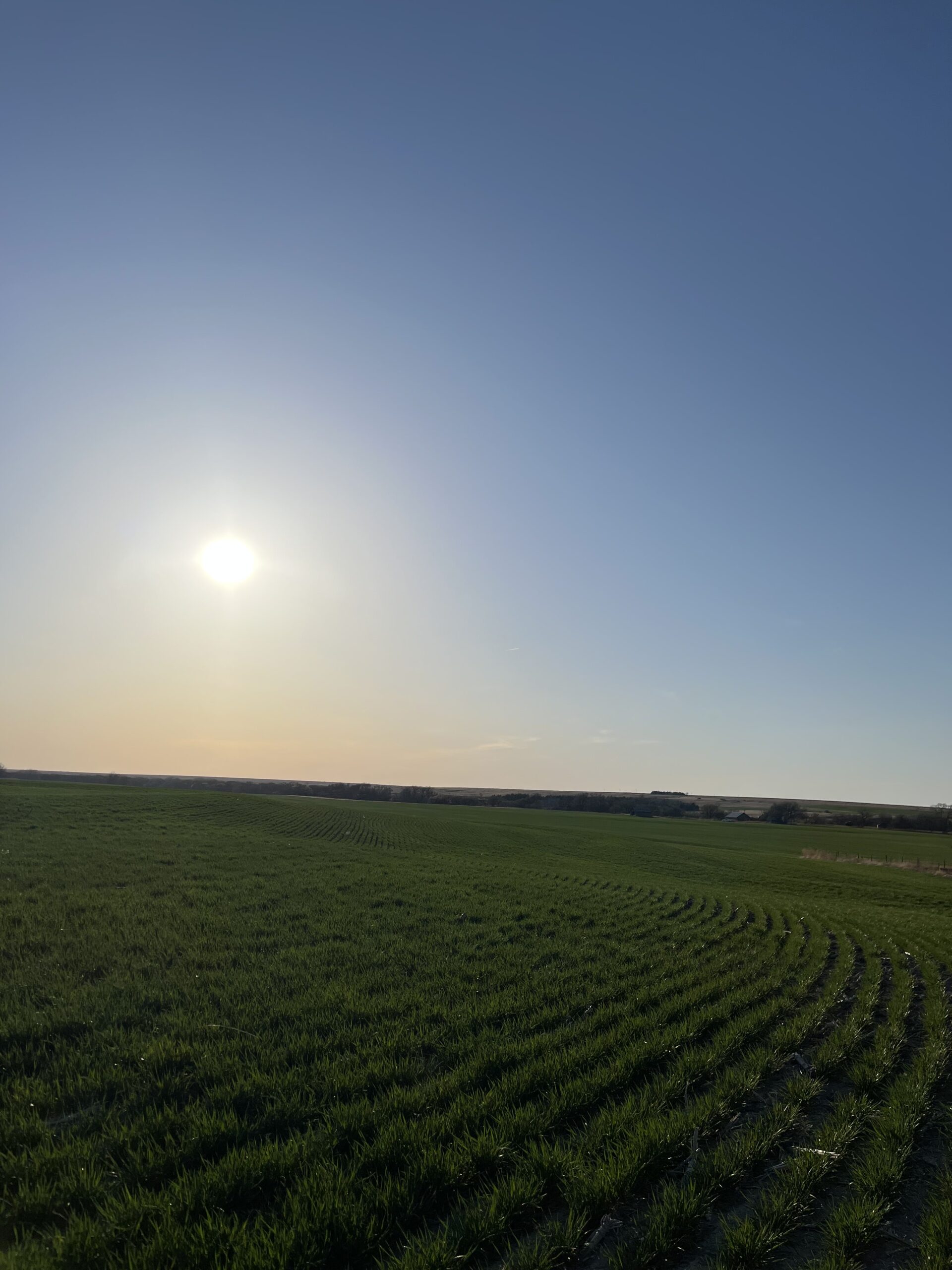
Kansas Winter Wheat, Photo Courtesy of Gannon Rush
Regional Breakdown
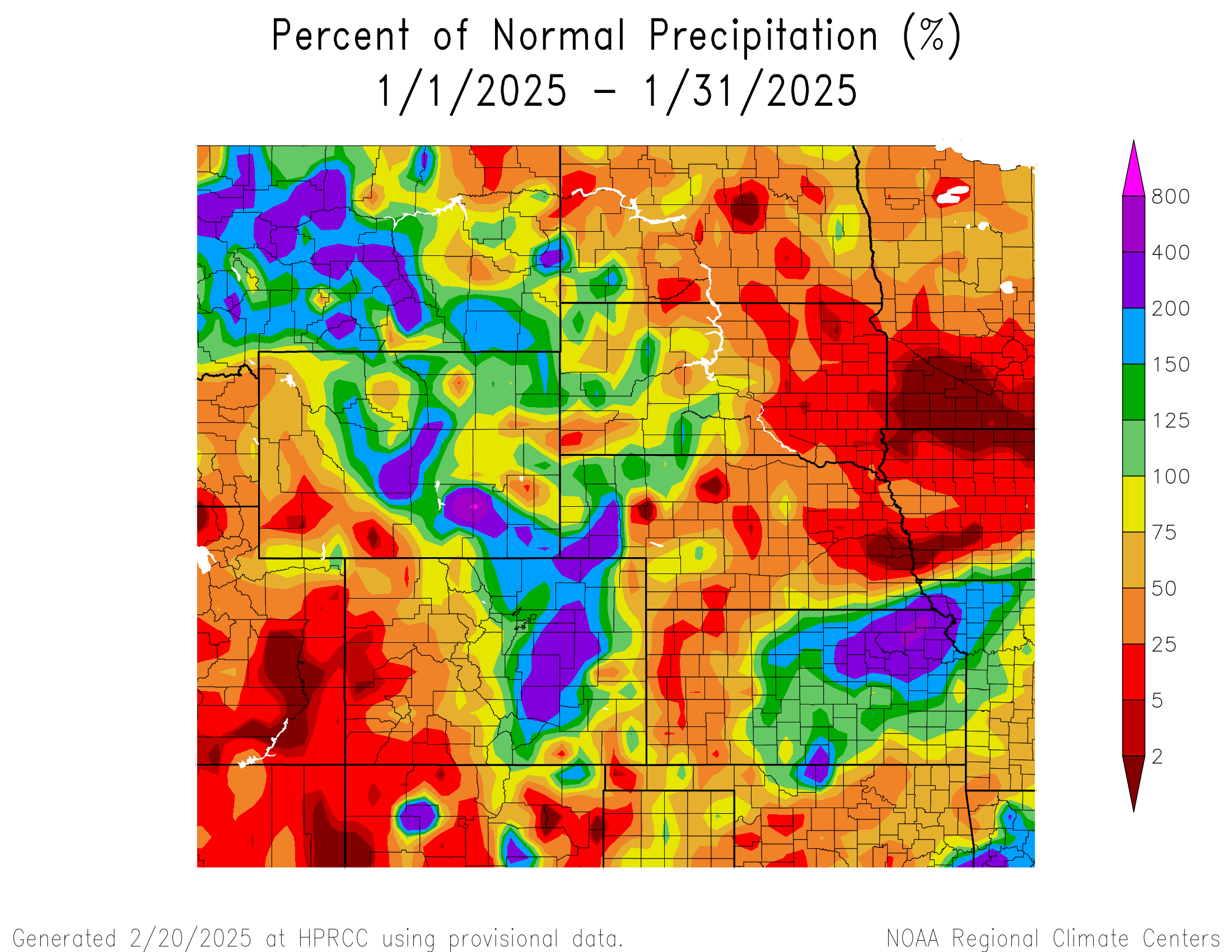
An impressive run of warmer temperatures stretching back to September ended this month, with much of the High Plains well below their normal temperatures. Outside of a few isolated snowstorms, snowfall has been at a minimum for many. Drought remains an issue, with the lack of widespread snowfall amplifying the concerns.
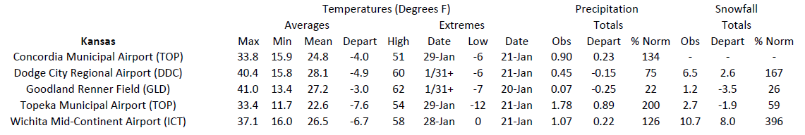
The first major winter storm impacted Kansas early in the month, with the east-central part of the state observing over 12 inches (30.48 cm) of snow in a single day. The tremendous snowfall totals shut down cities such as the Kansas City metro, Topeka, and Wichita. Along with the band of heavy snowfall, over 0.50 inches (12.7 mm) of ice accumulated in the central part of the state. Schools were canceled and thousands of homes lost power, while travel in the area was greatly hampered. Bone chillingly cold air rushed in after the snow had fallen, with subzero temperatures reported in the following days.
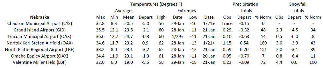
On the opposite end of the spectrum, snowfall is at record lows across central and eastern Nebraska. Omaha and Lincoln have only observed an inch (25.4 mm) of snow from October 1st through January 31st, the lowest snowfall for the period on record. In Kansas, areas west of Hays that missed the snowfall from the early January storm are also significantly below their normal amount. For example, Atwood has recorded less than an inch (25.4 mm), while Natoma and Hill City have only received trace amounts.
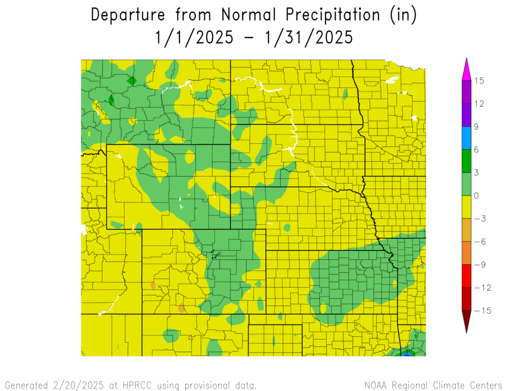
Precipitation and Water Resources
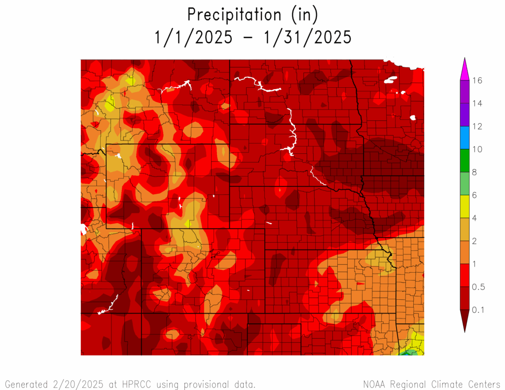
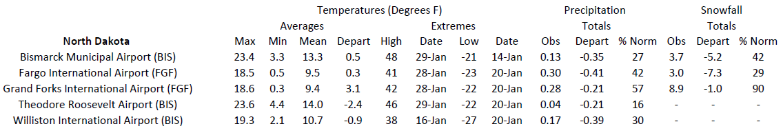
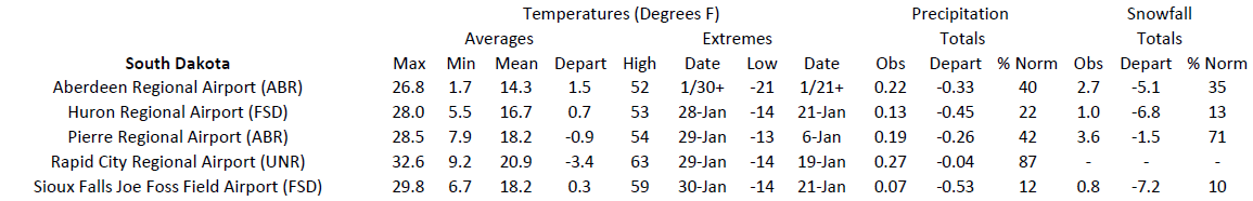
Outside of the snowstorms in eastern Kansas and along the front range, much of the region was dry this month. The eastern parts of the Dakotas and Nebraska were exceptionally dry, even for winter months, with less than 0.10 inches (2.54 mm) of precipitation.
The heavy snow in eastern Kansas dropped exceptionally large amounts in just a day, with 18 inches (45.72 cm) of snow falling in Chapman on the 6th. This incredible amount beat the previous single-day record by 2 inches (5.08 cm). Other locations in the Manhattan area such as Fort Riley received over 14 inches (35.56 cm). Combined with the ice and gusty winds, travel conditions were extremely dangerous. Aided by this heavy snowfall, Topeka tied with 2011 for the 5th snowiest January on record with 16.8 inches (42.67 cm). To the south in Wichita, 10.7 inches (27.18 cm) fell this month to rank 10th.
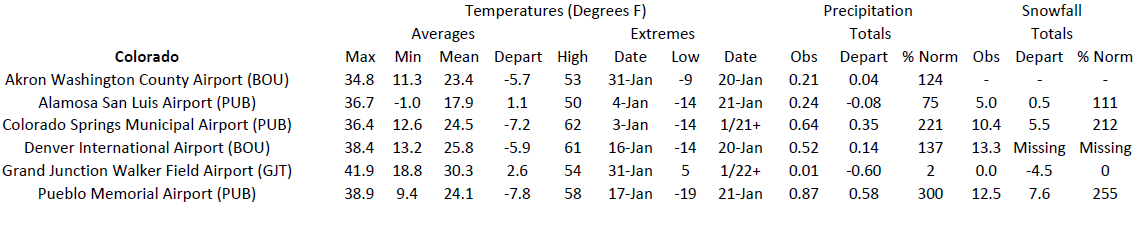
Out west in Colorado, several smaller snowstorms led several locations to rank in the top 10 snowiest. Pueblo recorded 12.5 inches (31.75 cm) of snow this month to rank 10th, while also ranking 6th wettest with 0.87 inches (22.1 mm) of precipitation. Just to the north, Colorado Springs ranked 7th snowiest with 10.4 inches (26.42 cm). In the western part of the state, snow was at a minimum with Grand Junction observing trace amounts to tie for 2nd lowest snowfall.
At the end of January, snowpack was in decent shape for most of the Rockies. Many basins are near or at median as of February 4th. The southwestern part of the state near Durango is well below median, with drought conditions degrading in the area as a result.
Temperatures
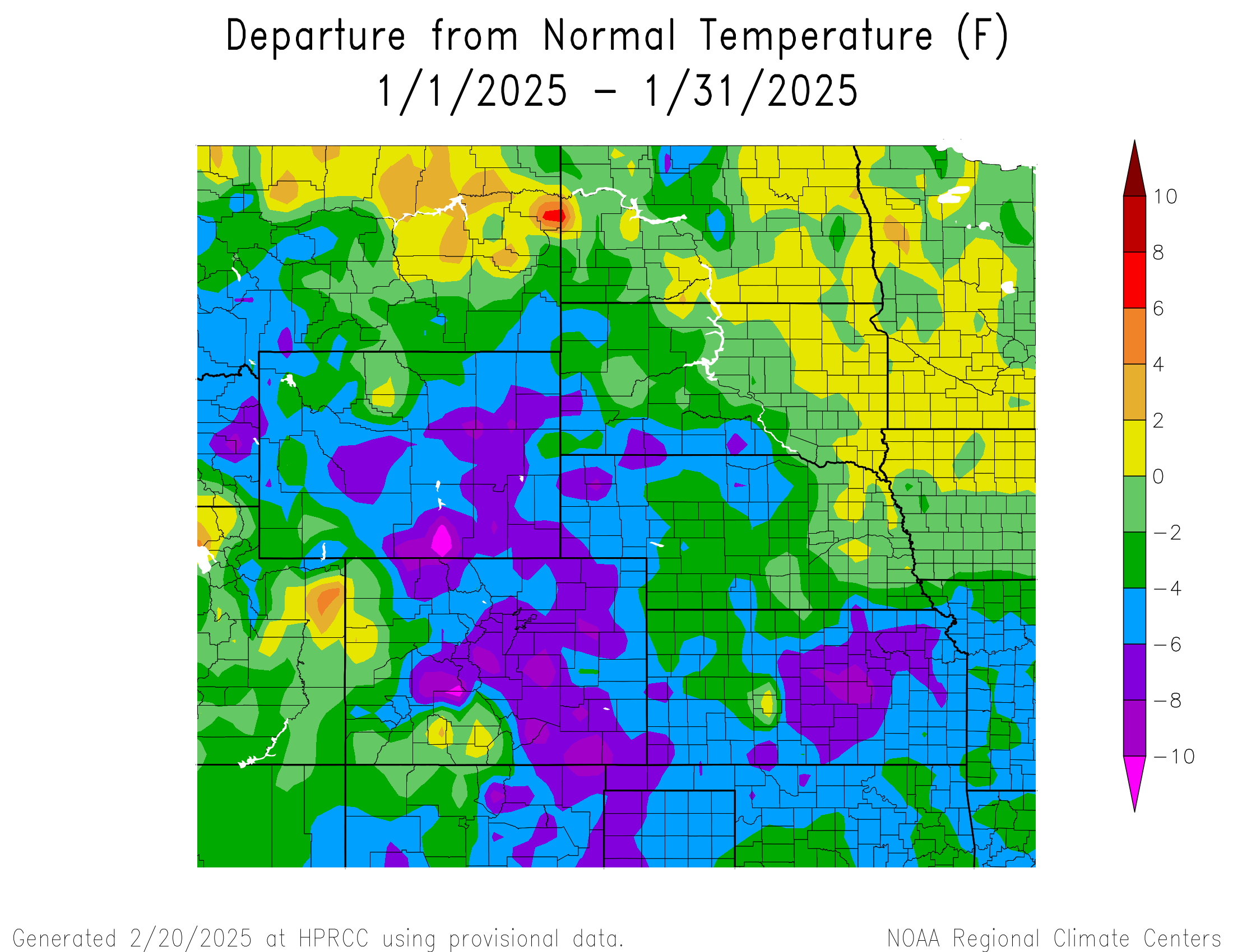
January was cooler than normal for much of the High Plains due to frigid temperatures in the middle of the month. Parts of Colorado, Kansas, and Wyoming were over 6 degrees F (3.3 degrees C) below normal, while the eastern portions of the Dakotas were slightly above normal. Even with the frigid temperatures, only a few locations ranked in the top 10 coldest.
The system that brought heavy snowfall to eastern Kansas kicked off a stretch of cooler temperatures for the region. Another much more powerful system arrived on the 18th, pushing freezing temperatures all the way to the Gulf Coast. In the High Plains, subzero temperatures occurred across the entire region. Bottineau, North Dakota reached –40 degrees F (-40 degrees C) on the 20th, while areas near Yellowstone National Park in Wyoming plummeted to –47 degrees F (-43.9 degrees C). A few days later on the 26th, Old Faithful recorded a low of –45 degrees F (-42.8 degrees C). This ranked as the coldest temperature on record in January and tied for 7th coldest overall. The Wichita, Kansas area recorded some of its coldest January temperatures in nearly 40 years during this period. The low was –8 degrees F (-22.2 degrees C) in Wichita on the 21st, the coldest January temperature since 1988. Nearby Salina was even colder at –13 degrees F (-25 degrees C) on the same day, marking the coldest January temperature since 1985.
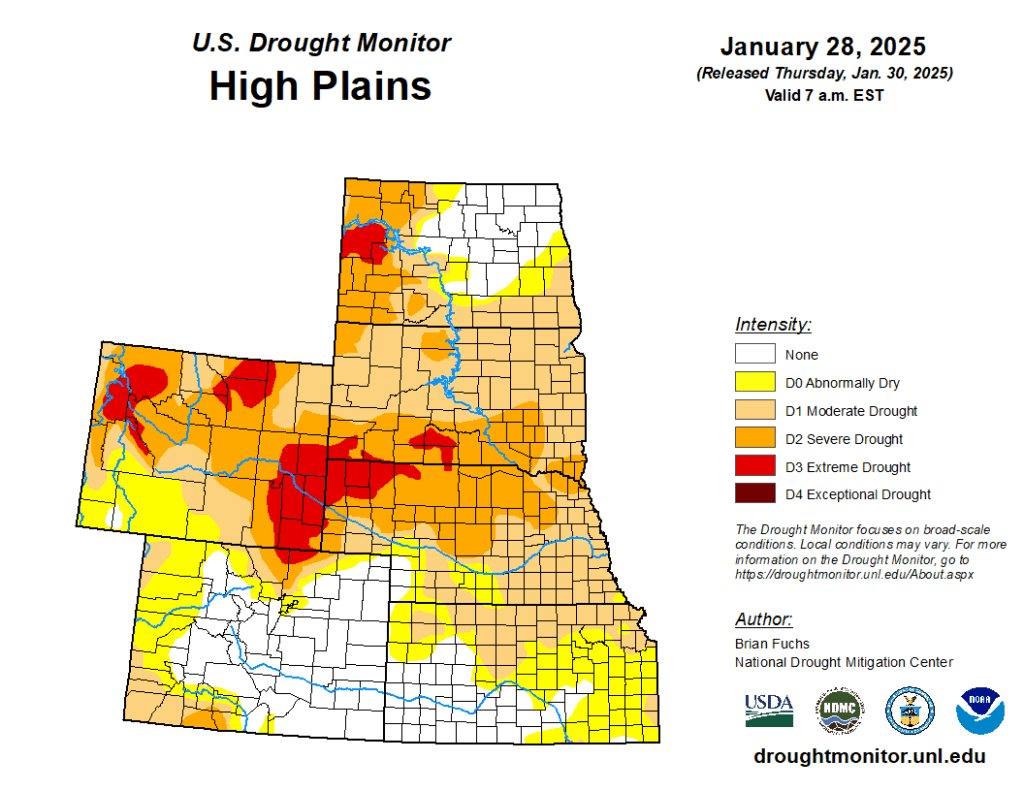
Drought Conditions
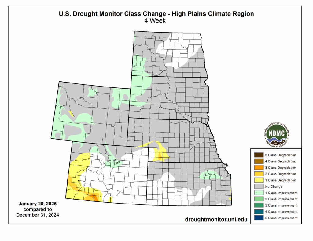
Drought intensity was improved throughout the High Plains this month, but the overall spatial extent increased. Changes this month predominantly occurred out west, where snowfall was hit or miss. Overall, the region experienced an increase of 3 percent in D0 to D4 (abnormally dry to exceptional drought conditions).
Improvements finally began to occur in Wyoming, after a rough 2024. D2 to D4 (severe to exceptional drought conditions) was reduced by nearly 12 percent in the northeastern and southwestern parts of the state. Despite the improvements, nearly the entire state is engulfed in D0 to D4.
In Colorado, conditions improved in the Denver area due to the several rounds of snow this month. Opposite of this, the Durango area experienced up to three classes of degradation due to the low snowfall. The western portion of the state also observed a large increase to D0, with areas such as Grand Junction reporting trace amounts of snow. Elsewhere in the region, other improvements and degradations were observed. According to the Climate Prediction Center’s U.S. Monthly Drought Outlook for February, drought conditions will likely continue to improve in Wyoming.
Department of Agriculture (USDA), National Drought Mitigation
Center, U.S. Department of Commerce, and the National Oceanic and
Atmospheric Administration (NOAA). For current Drought Monitor
information, please see: http://droughtmonitor.unl.edu/
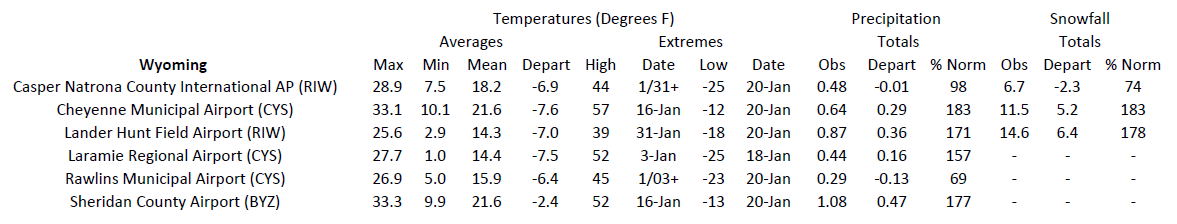
Station Summaries: By the Number
Download PDF Below