

December 2024 Climate Summary
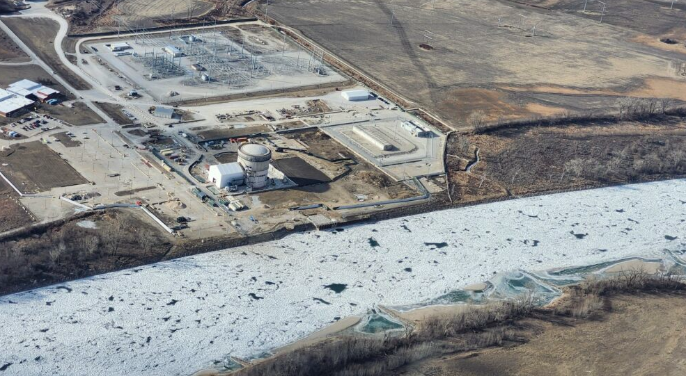
Ice jam in the Missouri River, Photo Courtesy of Omaha Public Power District
Regional Breakdown
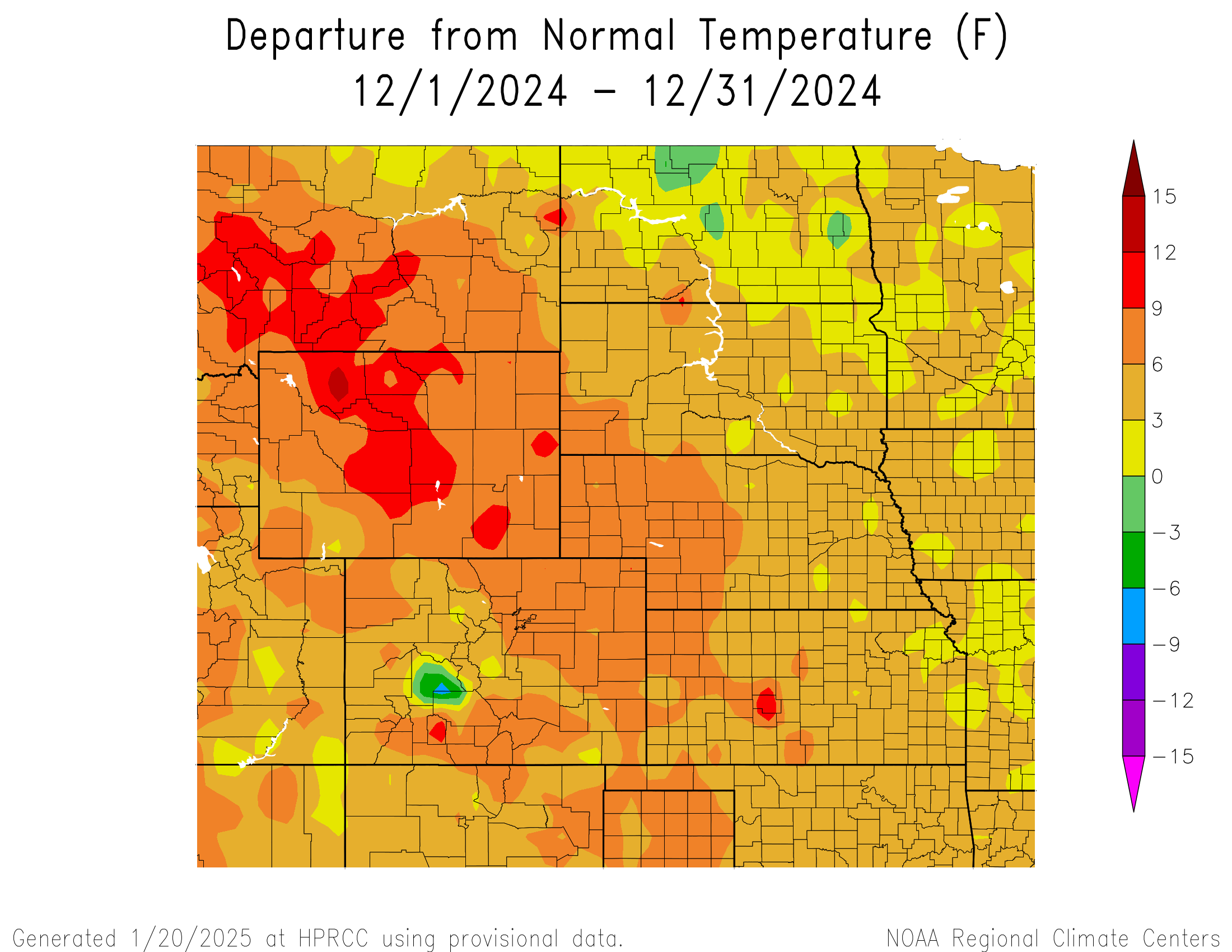
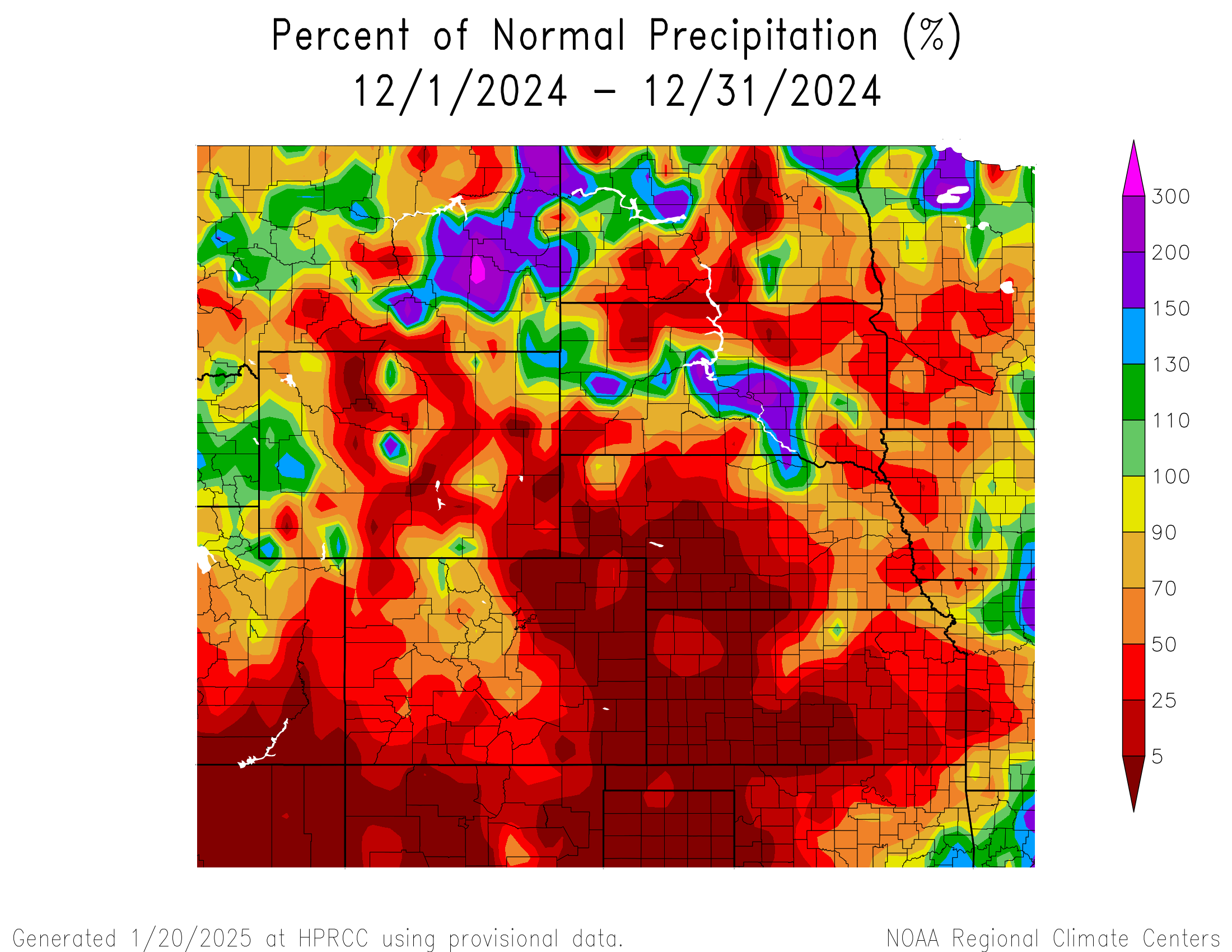
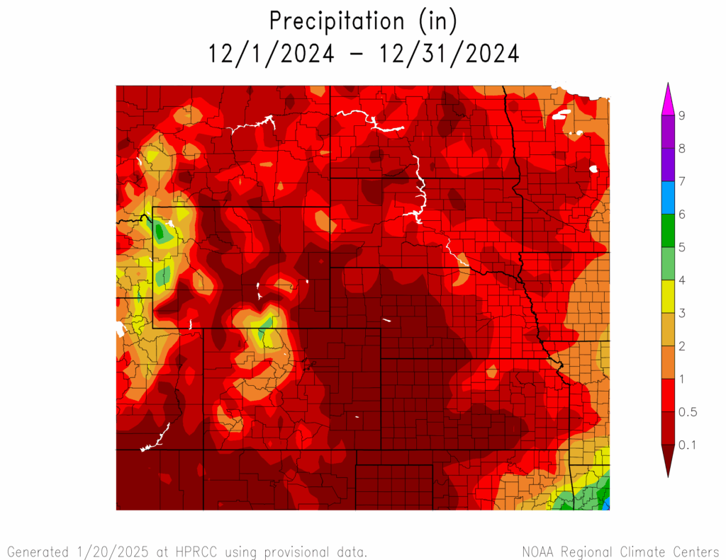
After a year full of extremes, December was a relatively quiet month for the High Plains. Temperatures continued to be above normal for the entire region, while many observed near-zero precipitation. Despite the warmer temperatures lingering into the end of the year, drought conditions did not change much this month.
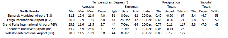
In an otherwise less than notable month, a fast-moving and impactful blizzard struck North Dakota in the middle of the month. Over 6 inches (15.24 cm) of snow fell in some places, with a few locations reporting more than 10 inches (25.4 cm). While not extreme nor significant by North Dakota standards, the snow combined with wind gusts of up to 50 mph (80 km/h) which created hazardous road conditions. 15 people were injured due to an accident caused by icy roads in the southwest part of the state. Of the injuries, 5 were considered serious. A no-travel advisory was issued, with a stretch of Interstate 94 closed for a short time.
Precipitation and Water Resources
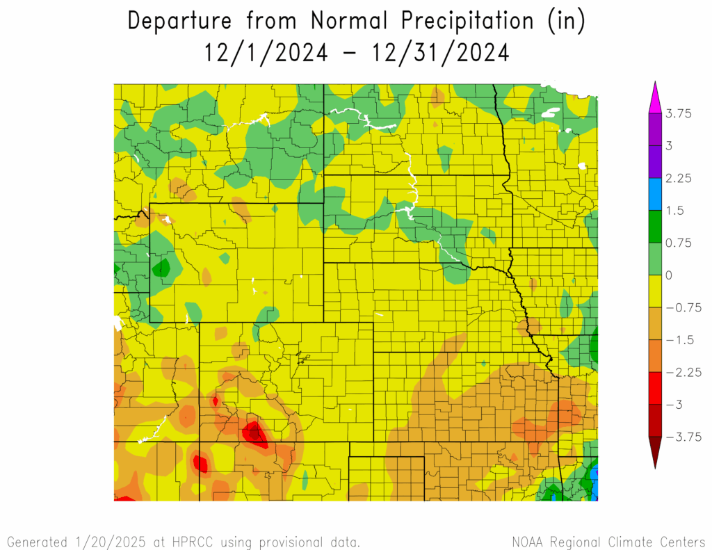
Outside of the blizzard in North Dakota, the region experienced minimal to zero precipitation. Nearly the entire region received less than an inch (2.54 cm) of precipitation this month, with a large swath reporting less than 0.10 inches (2.54 mm).
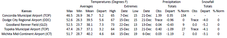
Western Kansas was among the driest this month, with dozens of stations reporting zero or trace amounts of precipitation. Among those reporting zero included Garden City, Greensburg, and WaKeeney. Dodge City experienced a massive flip, with 6.38 inches (16.21 cm) in November to trace amounts in December. The dryness also extended into the eastern portions of the state, with Wichita reporting a meager 0.03 inches (0.76 mm)
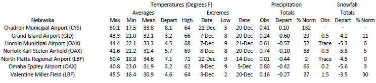
Just to the north in western Nebraska, several stations reported near-zero precipitation. No precipitation occurred in McCook, tying with 1922 and 1928 for the driest December. Nearby towns such as Cambridge and Culbertson also reported zero. Scottsbluff, Lexington, and Sidney reported trace, while North Platte, Holdrege, and Alliance observed less than 0.05 inches (1.27 mm).
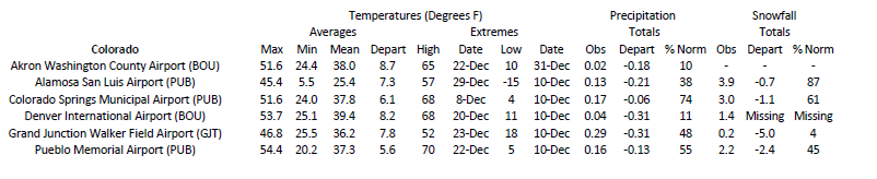
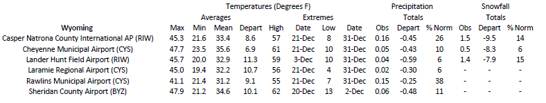
Along the Front Range, dozens of stations reported minimal amounts and nearly no snowfall. For Colorado, this included Denver, Fort Collins, Akron, and Lamar. Across the border in Wyoming, areas such as Sheridan, Lander, and Cheyenne all reported less than 0.06 inches (1.52 mm) of precipitation.
Snow water equivalent (SWE) in the west is in good shape, with only a few basins below median. Percentiles in Wyoming have improved since November, with only three basins reporting below 70 percent as of January 5th. Much of Colorado remained near or above 100 percent at the end of the month.
Temperatures
December capped off a record warm year, with temperatures over 9 degrees F (5 degrees C) above normal in parts of the region. Wyoming was the warmest, with the northwestern portions of the state reaching up to 12 degrees F (6.7 degrees C) above normal.
Dozens of stations recorded their warmest December in Wyoming, particularly in the upper elevations. Casper Mountain at an elevation of 7,740 feet (2,359 m) broke their record by a degree (0.6 degrees C), with an average temperature of 29.1 degrees F (-1.6 degrees C). A notable record broken was from Worland just north of Riverton. The town recorded an average temperature of 29.7 degrees F (-1.3 degrees C), breaking the December record for the nearly 120-year-old station.
To the south in Colorado, numerous stations also recorded their warmest December, most notably along the Front Range. These included Akron and Sedgewick, while others such as Denver and Colorado Springs fell just short. The warmth also spread into the mountains, with the popular skiing town of Vail setting its record average maximum temperature for December with an average high of 34.2 degrees F (1.2 degrees C).
Drought Conditions
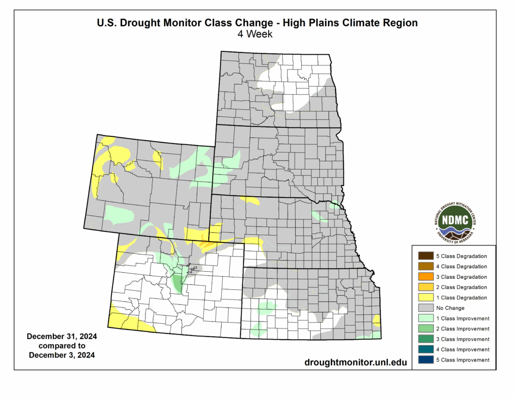
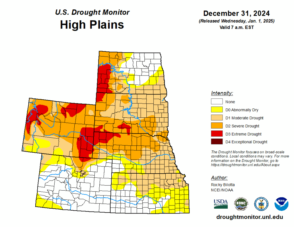
Despite the overall warmth and dryness this month, significant changes to drought conditions did not occur. What changes did occur were predominantly in the western portions of Colorado and Wyoming. Overall, the region observed a decrease of less than a percent in abnormally dry to exceptional drought conditions (D0 to D4).
Due to the tremendous snowfall totals in the winter storm in November, drought conditions improved along the Rockies in central Colorado. The northern part of the Front Range near Fort Collins was not as fortunate, with extreme drought (D3) expanding in the area. The southwestern part of the state had been nearly drought-free the previous few months, however, D0 remerged after little precipitation this month.
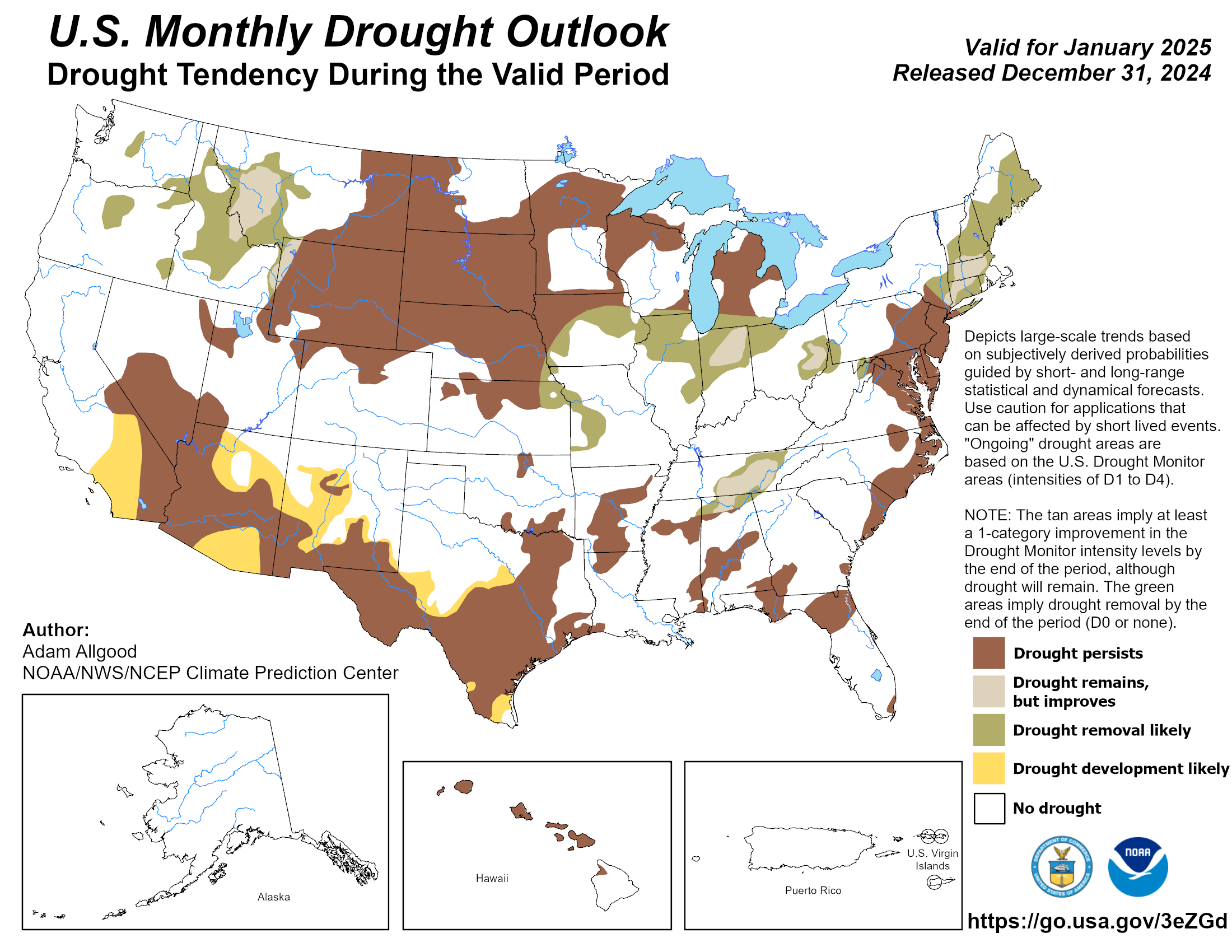
In Wyoming, drought conditions improved overall but intensified in parts of the state. D3 was reduced in the northeastern part of the state but expanded in the western portions and the Cheyenne area. At the end of the month, the entire state was still engulfed in D0 to D4. Elsewhere in the region, other improvements and degradation were observed. According to the Climate Prediction Center’s U.S. Monthly Drought Outlook for January, minor improvement to drought could occur in Kansas and Wyoming.
Department of Agriculture (USDA), National Drought Mitigation
Center, U.S. Department of Commerce, and the National Oceanic and
Atmospheric Administration (NOAA). For current Drought Monitor
information, please see: http://droughtmonitor.unl.edu/
Climate Outlooks
According to the Climate Prediction Center, ENSO-neutral conditions are present. A La Niña watch is currently in effect. For more information, visit https://www.cpc.ncep.noaa.gov/products/analysis_monitoring/lanina/enso_evolution-status-fcsts-web.pdf
The National Weather Service’s long-range flood outlook indicates minimal chances of flooding along the Missouri River through March. According to the National Interagency Fire Center (NIFC), fire potential will be near normal through April.
The seasonal temperature and precipitation outlook presented below combine the effects of long-term trends, soil moisture, and when applicable, the El Niño Southern Oscillation (ENSO). To learn more about these outlooks, please visit http://www.cpc.ncep.noaa.gov.
Temperature
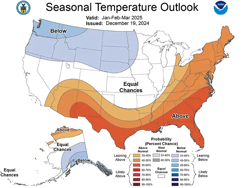
The three-month temperature outlook shows an increased chance of above-normal temperatures across the much of the southern and eastern United States, while below-normal temperatures are favored across the northern parts. Above-normal temperatures are possible in western Colorado and below-normal temperatures are favored in the Dakotas, Wyoming, and most of Nebraska.
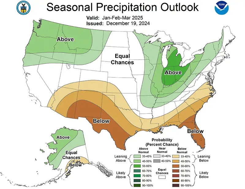
Precipitation
The outlook for the next three months indicates below-normal precipitation across the southern United States, while above-normal is possible in the northwest and Great Lakes. Below-normal precipitation is possible in Colorado and Kansas, while above-normal is possible in Wyoming.
Drought
The U.S Seasonal Drought Outlook released on December 31st indicates that drought development improvements are possible in Kansas, Nebraska, and Wyoming.
Station Summaries: By the Number
Download PDF Below