

February 2025 Climate Summary
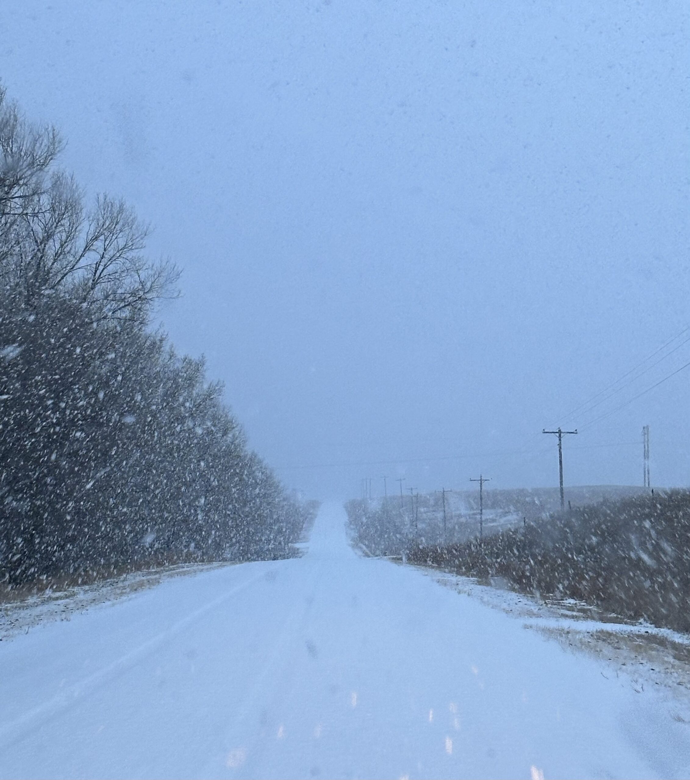
Heavy snowfall in Kansas, Photo Courtesy of Gannon Rush
Regional Breakdown
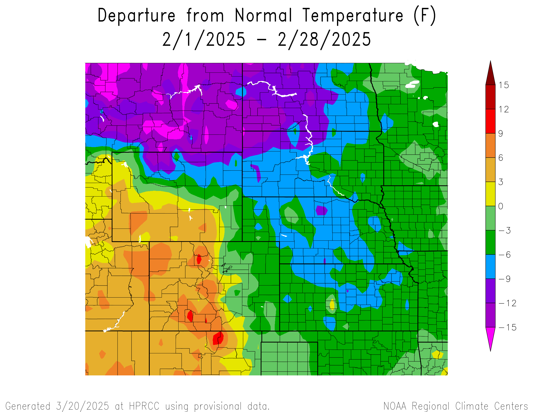
After a relatively mild winter for many in the High Plains, February brought bone-chilling cold and snow across the majority of the region. On the opposite end of the spectrum, parts of Colorado and Wyoming had a record to near-record warmth this month.
Similar to January, an impactful Arctic air outbreak spread across the region in the middle of the month. Temperatures reached as low as –45 degrees F (-42.8 degrees C) in North Dakota, while wind chills dipped below –60 degrees F (-51.1 degrees C). The cold stretched across nearly the entire region, with temperatures reaching –21 degrees F (-29.4 degrees C) as far south as Manhattan, Kansas. Along with the freezing temperatures, heavy snow fell in some places. Scottsbluff, Nebraska reported nearly 14 inches (35.56 cm) of snow between the 16th and the 18th. Schools were closed throughout many states during this period, while hundreds of wrecks were reported. Unfortunately, one person was killed on I-80 in central Nebraska due to the winter weather.
As temperatures began to warm back up towards the end of the month, a highly unusual and historic event occurred in South Dakota on the 24th. While conditions were not favorable for severe thunderstorms, the local environment near Watertown was just conducive enough to produce a weak and brief tornado. No damage was reported, while small pea-sized hail fell. This would be the first recorded tornado in South Dakota for the month of February.
Precipitation and Water Resources
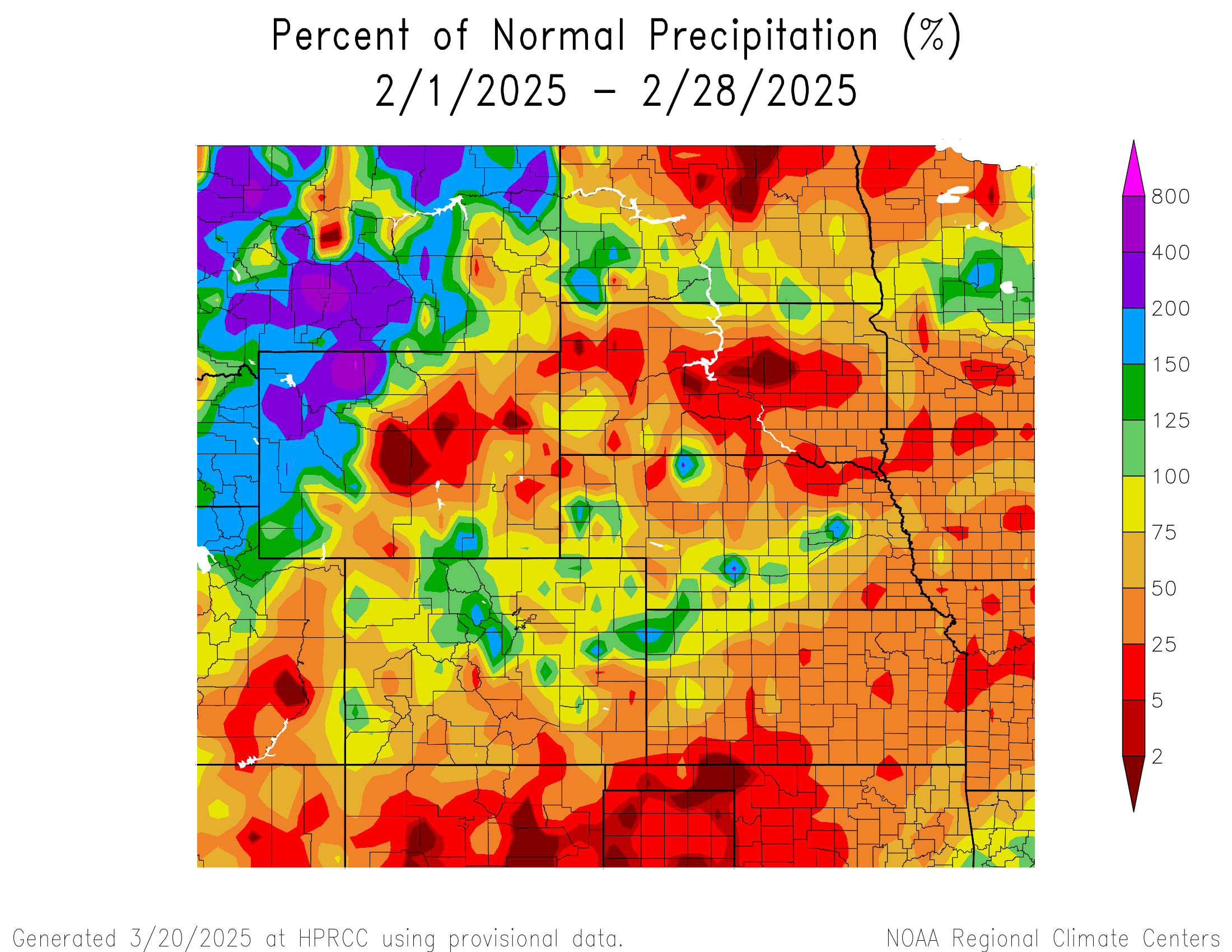
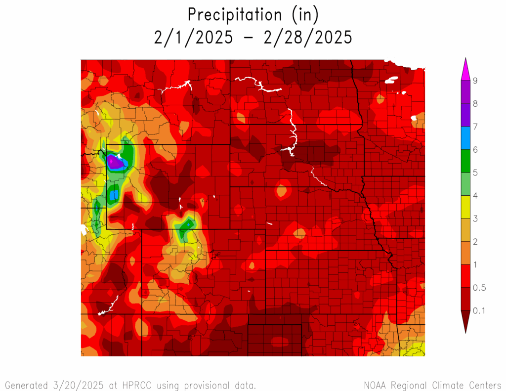
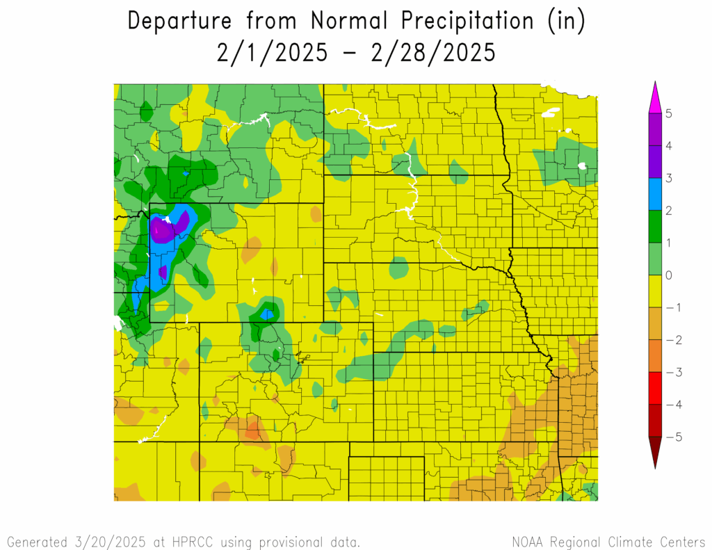
Precipitation was below normal for much of the High Plains this month. Even with the beneficial snowfall across portions of the region in February, many places in the plains are 20 inches (50.8 cm) below their normal snowfall.
Northwestern Kansas and the panhandle of Nebraska were fortunate enough to receive much-needed snowfall in February but still remain below normal for the year. Goodland, Kansas recorded 17.0 inches (43.18 cm) of snow to tie with 1997 for the 4th highest snowfall. To the north in Nebraska, Scottsbluff observed 16.5 inches (41.91 cm) to rank 8th snowiest. Despite the heavy snowfall around Scottsbluff, the area is still greater than 15 inches (38.1 cm) below normal. On the opposite end of the spectrum, portions of South Dakota recorded zero to minimal amounts of snow. Pierre observed just 0.5 inches (12.7 mm) in February to rank 5th lowest while other areas in the central part of the state such as Onida did not report any snow.
For the winter, the lower elevations in western Colorado experienced well below normal snowfall. Grand Junction only recorded 0.4 inches (10.16 mm) of snow, the lowest amount in the 100 plus year history by a large margin. The previous record was 2.3 inches (5.84 cm) in the winter of 1960-61. The town also recorded its 4th driest winter, with only 0.54 inches (13.72 mm) of liquid precipitation. Out on the plains, a burst of snow in the middle of February helped prevent Lincoln, Nebraska from recording its lowest snowfall. After 5.2 inches (13.21 cm) fell in a little over a week, Lincoln would observe 6.2 inches (15.75 cm) for the winter to rank 10th lowest snowfall.
At the end of February, snowpack remained in decent shape for most of the Rockies. Many basins are near or at median as of March 4th. Southwestern Colorado has had below normal snowfall this year, with the basins in the area reporting near 60 percent of median
Temperatures
Temperatures in February were polar opposites for parts of the High Plains. Much of the region was blanketed by bone-chilling cold, however, western Colorado and southern Wyoming recorded above normal temperatures. Both extremes occurred, with locations ranking in the top 10 coldest and warmest.
The arctic air outbreak that enveloped the majority of the region led to numerous records broken and absurdly cold wind chills. Hettinger, North Dakota recorded an air temperature of –45 degrees F (-42.8 degrees C) on the 19th, the coldest temperature observed in the town since 1936. Further north, wind chill reached –61 degrees F (-51.7 degrees C) in Crosby just a few days earlier on the 17th. In the days following the extreme cold, temperatures rapidly flipped in just a week by over 100 degrees F (55.5 degrees C). Parts of central Nebraska went from –29 degrees F (-33.9 degrees C) to 75 degrees F (23.9 degrees C) in just 5 days.
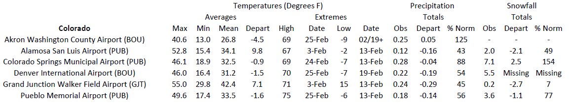
In the west, temperatures were exceptionally warm. Alamosa, Colorado recorded their warmest February on record with an average temperature of 34.1 degrees F (1.2 degrees C), beating the previous record set in 1995 by nearly a degree (0.6 degree C). The town also tied with 1995-96 for the 3rd warmest winter with an average temperature of 25.8 degrees F (-3.4 degrees C). Nearby Grand Junction observed their 3rd warmest February and 6th warmest winter. To the north in Wyoming, Rawlins ranked 8th warmest with an average temperature of 30.2 degrees F (-1 degrees C).
Drought Conditions
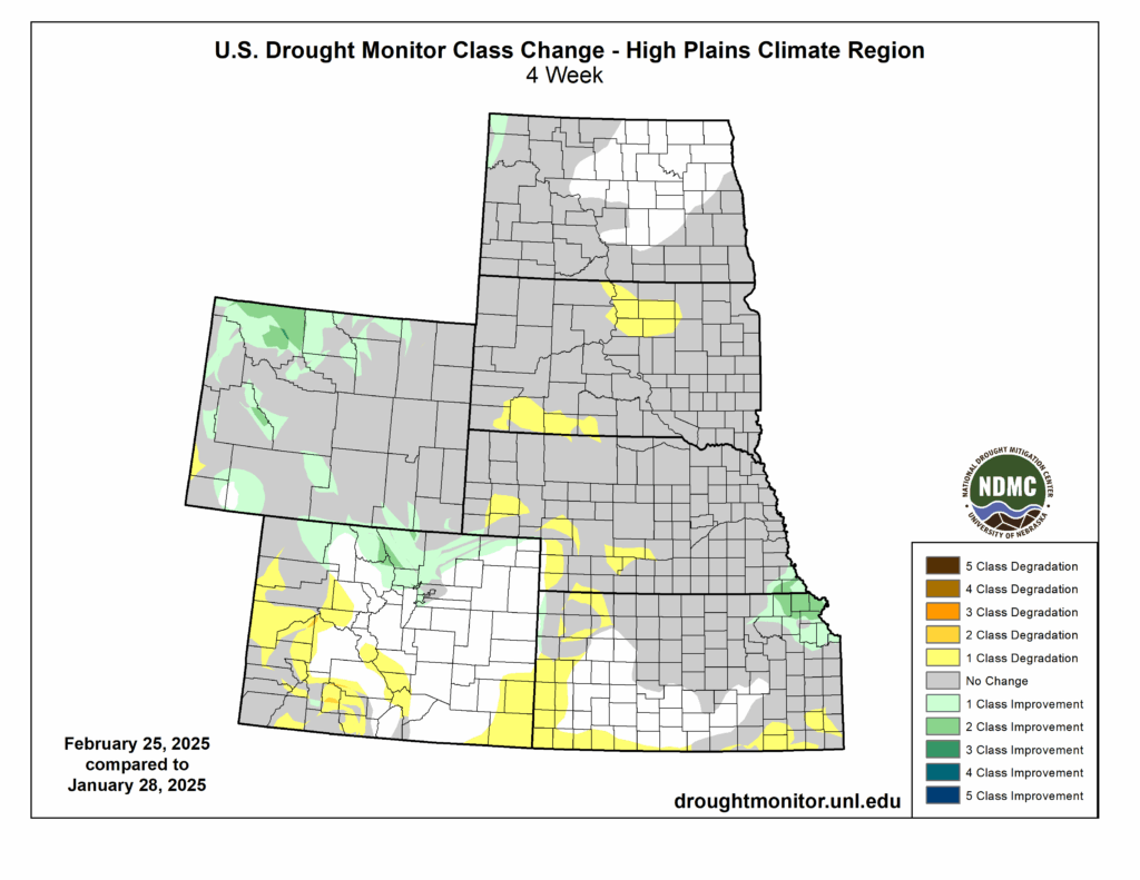
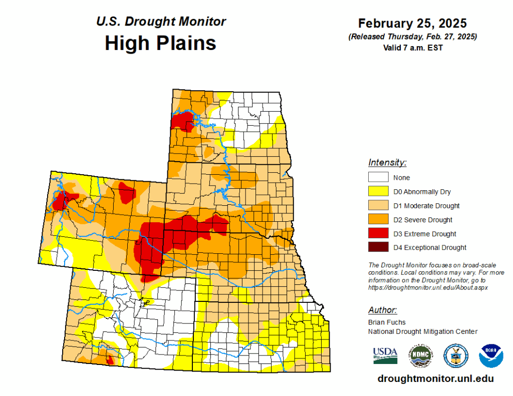
Minor changes occurred to drought conditions this month, with drought firmly entrenched in several areas across the western High Plains. Areas that did receive snowfall this month experienced improvements, notably in northwestern Wyoming. Overall, nearly 79 percent of the region is observing D0 to D4 (abnormally dry to exceptional drought).
Drought in northwestern Wyoming improved up to three classes this month due to the heavy snowfall. Severe drought (D2) and extreme drought (D3) were reduced in the area, however, minimal changes occurred throughout the rest of the state. Even with the improvements, over 96 percent of the state is still experiencing D0 to D4.
In Colorado, the above normal temperatures and lower snowfall have begun to take its toll on the western portions of the state. The lack of snowfall in the area prompted the introduction of D3 to an area southwest of Alamosa. While there are not typically drastic changes to drought conditions during the winter months, the snow drought has led to up to 4 classes of degradation since the beginning of 2025.
Elsewhere in the region, other improvements and degradation were observed. According to the Climate Prediction Center’s U.S. Monthly Drought Outlook for March, drought conditions will likely persist throughout the region.
Department of Agriculture (USDA), National Drought Mitigation
Center, U.S. Department of Commerce, and the National Oceanic and
Atmospheric Administration (NOAA). For current Drought Monitor
information, please see: http://droughtmonitor.unl.edu/
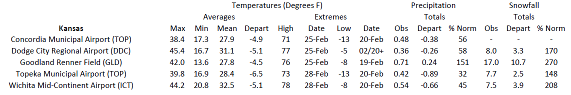
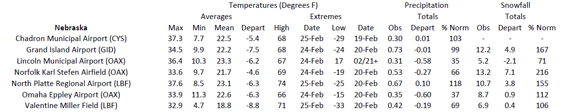
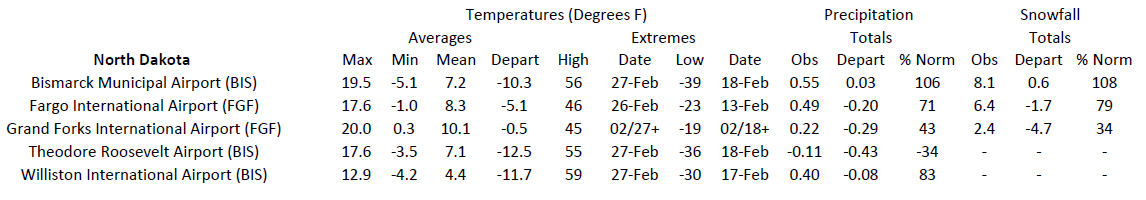
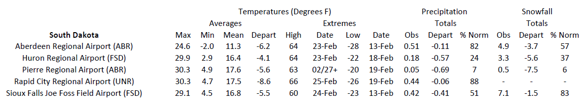
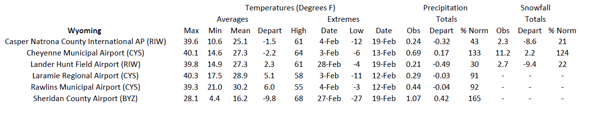
Station Summaries: By the Number
Download PDF Below