

November 2024 Climate Summary
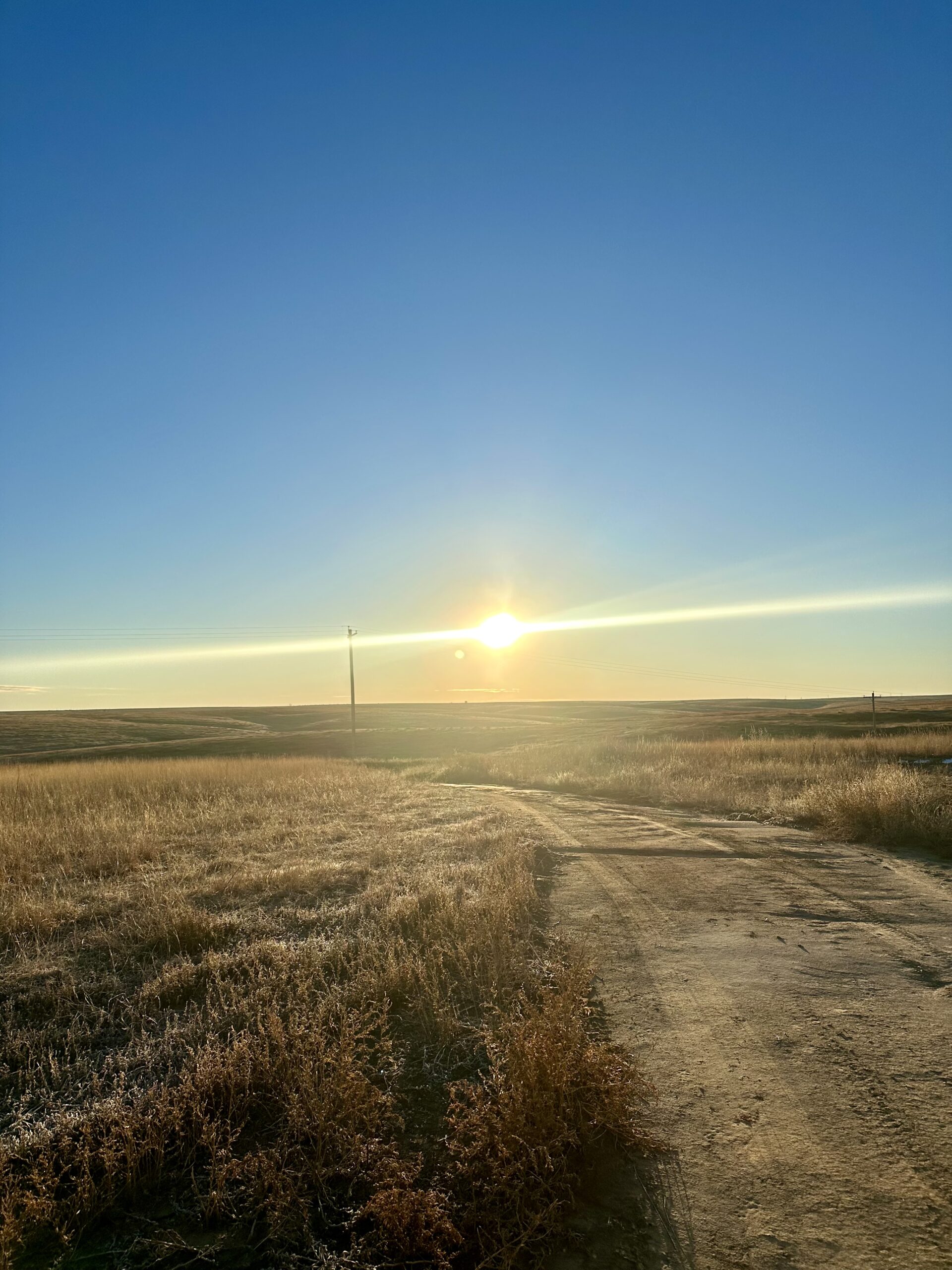
Sunrise in Western Kansas, Photo Courtesy of Gannon Rush
Regional Breakdown
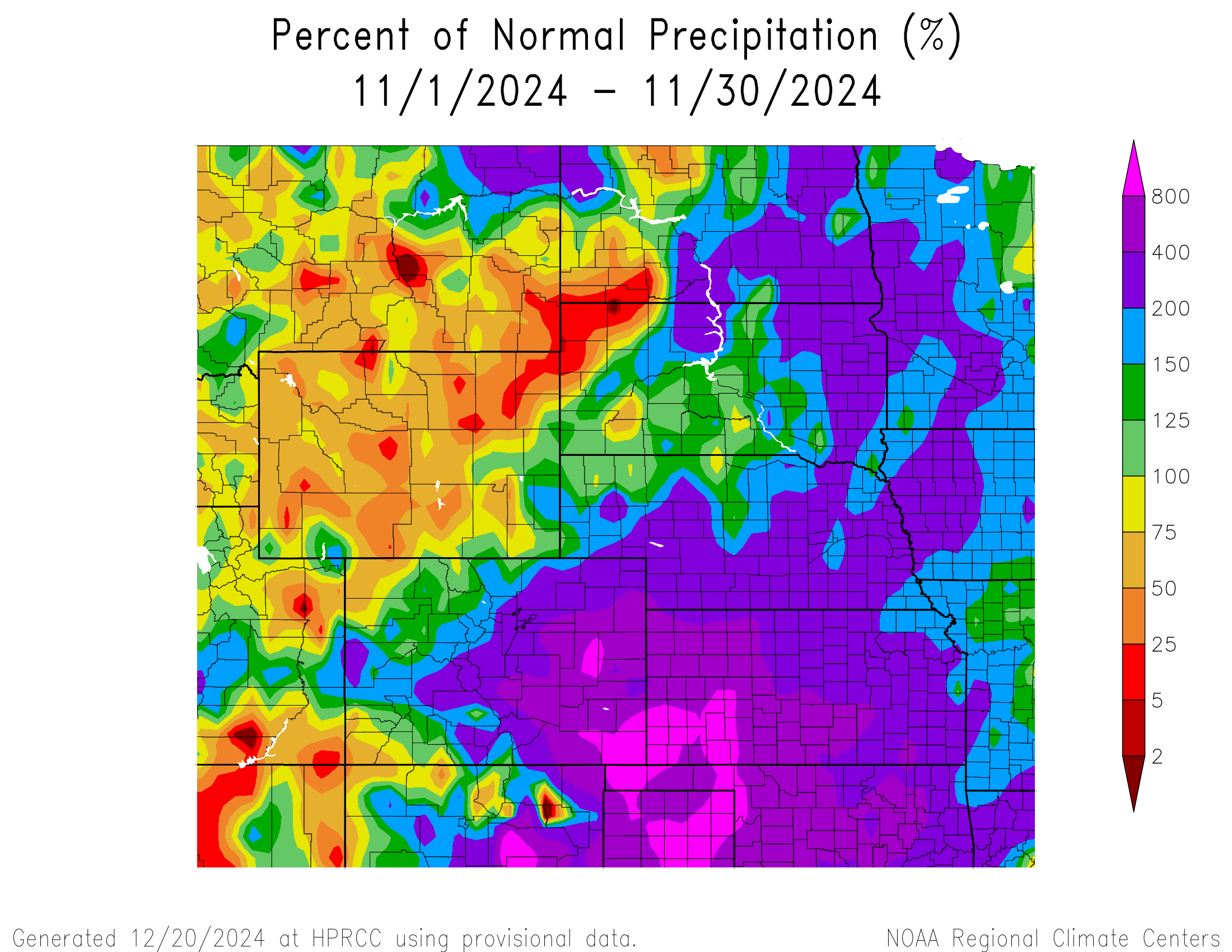
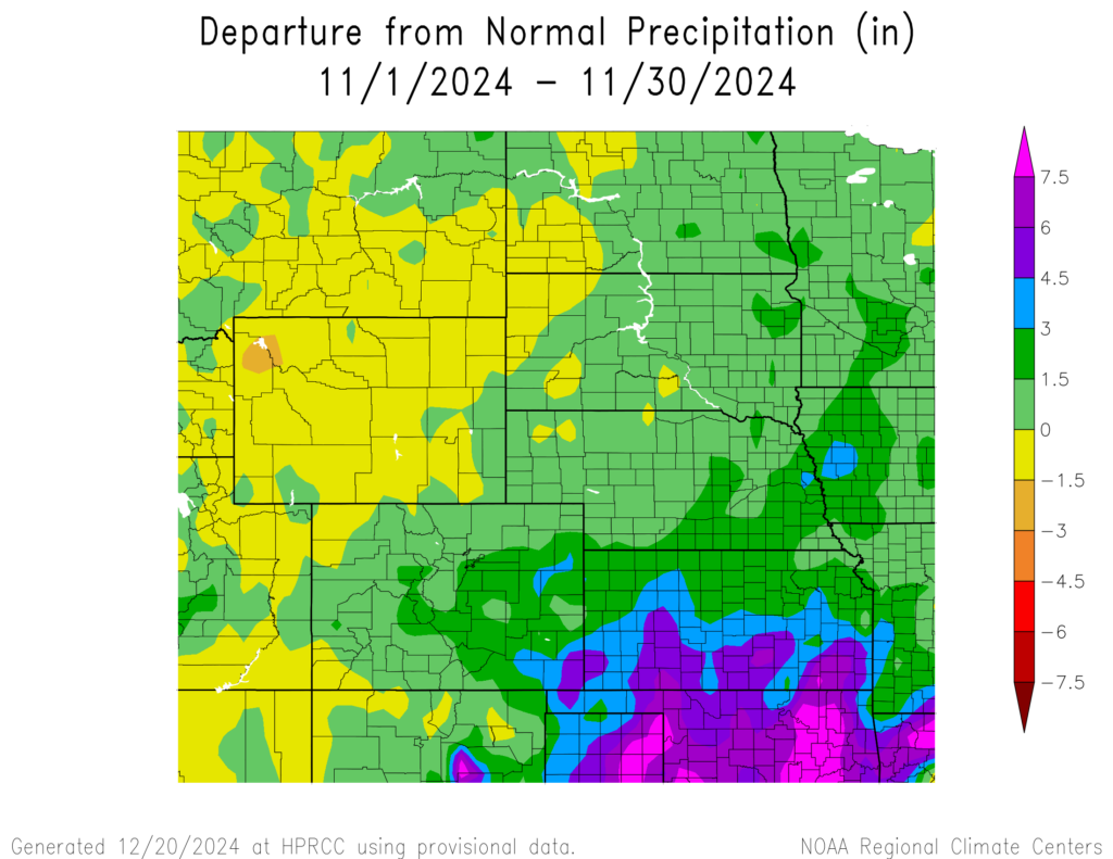
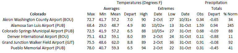
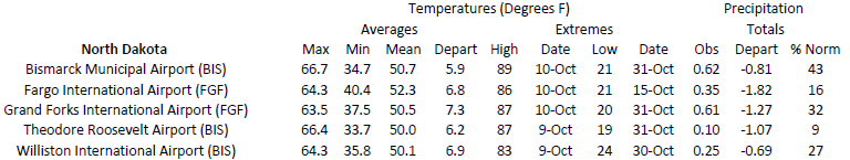
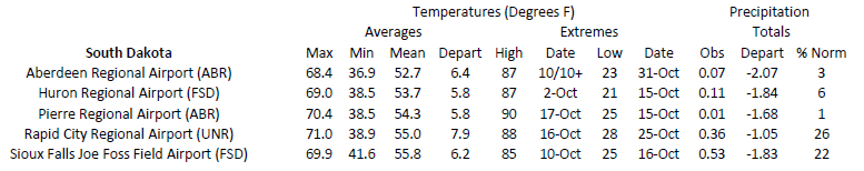
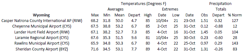
The steady intensification of drought conditions across the High Plains was halted in November, with large portions of the region observing over 200 percent of their normal precipitation. However, Parts of Wyoming and the Dakotas were not as fortunate, missing out on the much-needed precipitation. Outside of Colorado, temperatures remained above normal at the end of the fall season.
Two major snowstorms impacted Colorado this month, one of which struck the state ahead of Thanksgiving. The first storm took place beginning on the 5th and ended early on the 9th. Travel was greatly hampered, with both I-70 and I-25 shut down. Roughly 1000 flights were canceled or delayed at Denver International due to the storm, while thousands of people were without power in the city. On the plains east of Denver, over 100 pronghorns were found dead after the heavy snow forced them onto roads. The equivalent liquid precipitation from this storm was over 3 inches (7.62 cm) in some areas, which translates to roughly 20 percent of their annual precipitation. A second storm just before Thanksgiving disrupted travel plans and caused havoc on I-70 in the mountains. Dozens of avalanches were reported across the state, including near popular locations such as Breckenridge.
Precipitation and Water Resources
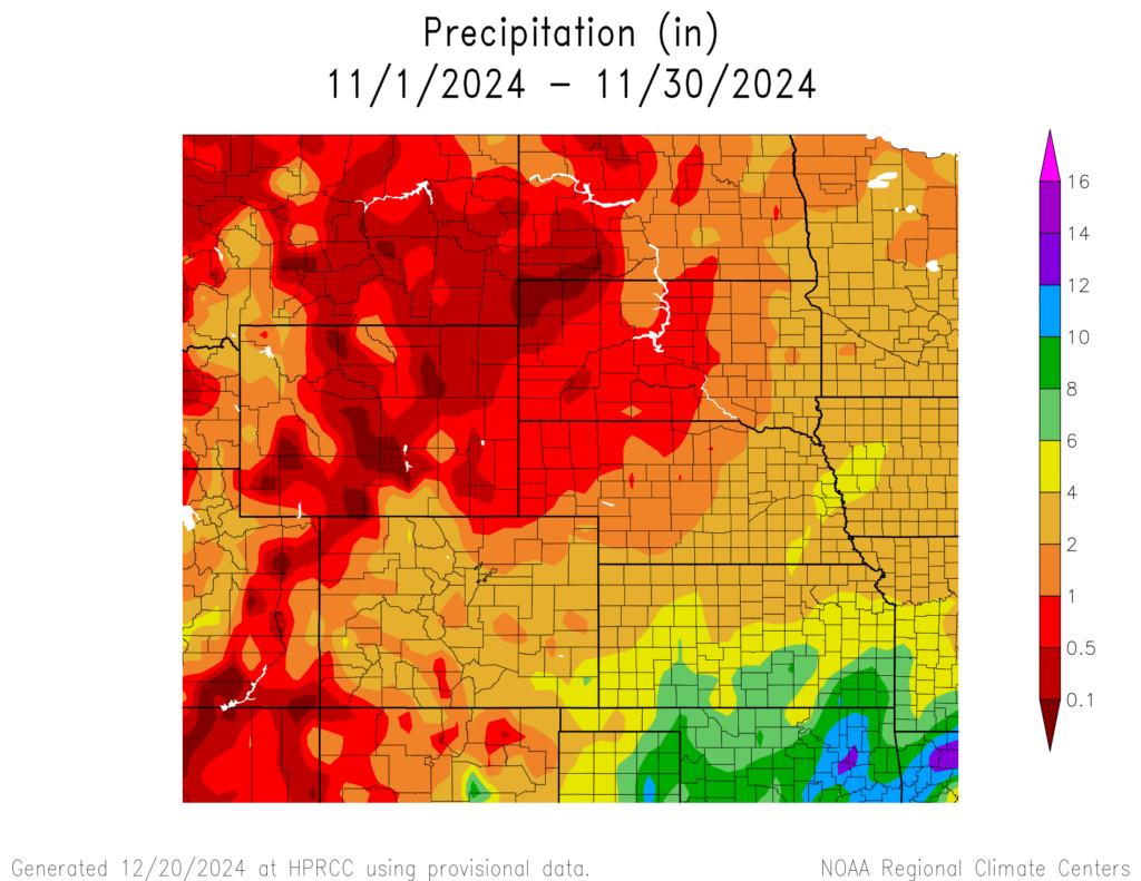
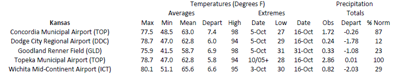
After near-record levels of dryness this fall, November brought well above normal precipitation for much of the region. The majority of Kansas was above 200 percent of normal, while areas near Dodge City reached as high as 800 percent. Some areas in the western High Plains were nearly bone dry, with up to 0.10 inches (2.54 mm) of precipitation.
Kansas received generous amounts of precipitation this month, with multiple locations recording their wettest November. Notable long-term stations setting their record included Dodge City, Goodland, and Wichita. The southeastern part of the state had several locations observe more than 10 inches (25.4 cm) this month, with up to 6 inches (15.24 cm) falling on the 3rd. Pittsburg nearly set the statewide November precipitation record, with 11.80 inches (29.97 cm) of precipitation.
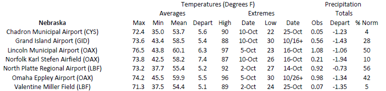
Parts of Nebraska were near record to record wettest this month. Lincoln and Omaha ranked third and seventh, respectively, after receiving over 3 inches (7.62 cm). Beatrice broke their previous record by over an inch (2.54 cm), with 4.50 inches (11.43 cm) falling this month. Other places in the state observing record precipitation this month were Minden and Mead.
A very early-season snowstorm in Colorado dumped record-breaking amounts of snow early in the month. Over two feet of snow (60.96 cm) fell in places across the state on the 7th, causing a multitude of problems. Several other snowstorms impacted parts of Colorado, including another one on the 27th that dropped over a foot (30.48 cm) in the mountains. At the end of the month, several stations near Mount Lindsey (east of Alamosa) recorded over 50 inches (1.35 m) of snow.
Aided by the heavy snowfall this month, snow water equivalent (SWE) is above to well above median in Colorado. The Arkansas basin in the southeastern corner of the state is at 161 percent of median as of December 4th. Wyoming has not been as fortunate, with no basins reporting above 80 percent of median SWE.
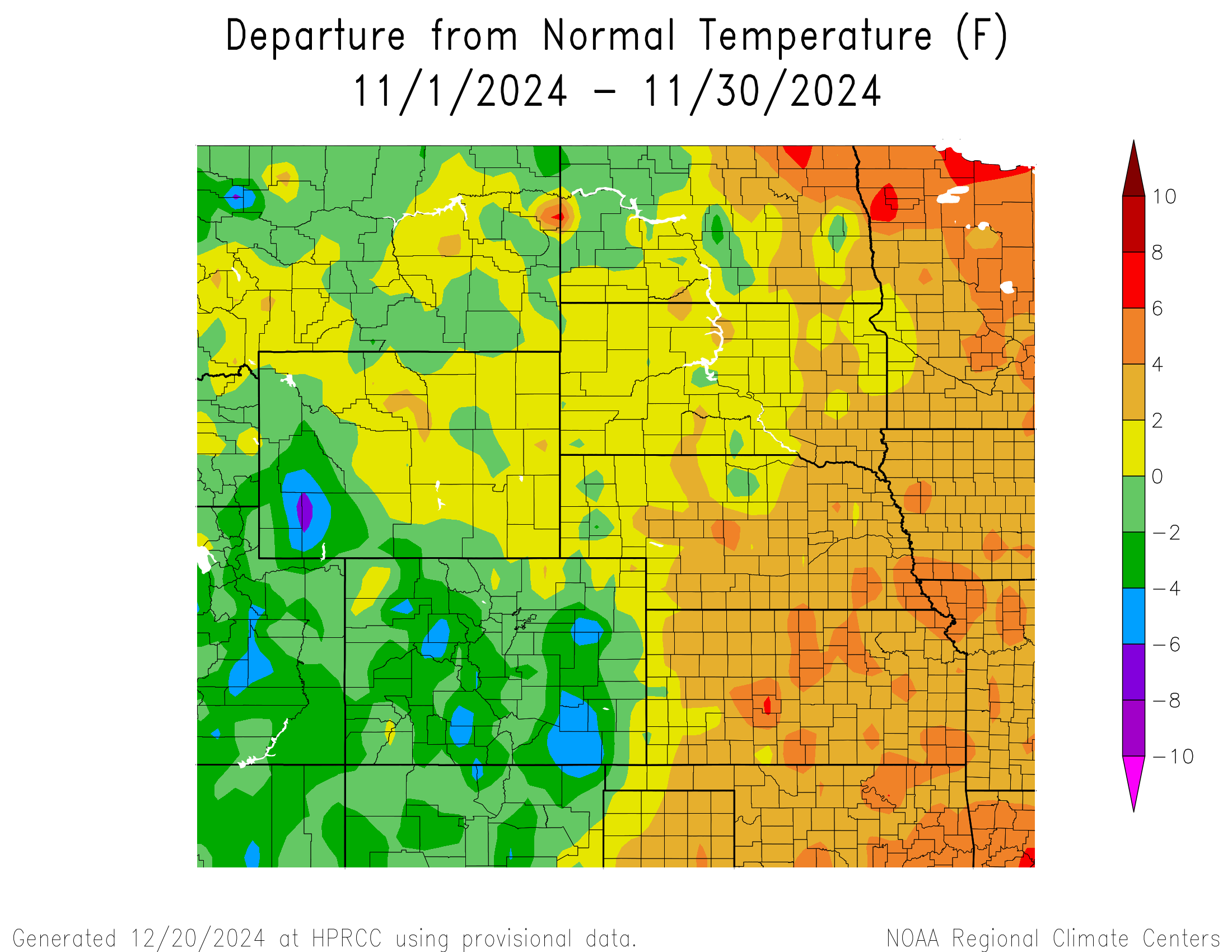
Temperatures
Temperatures began to cool off in Colorado and western Wyoming this month, but the rest of the region remained above normal. Parts of Kansas and Nebraska were up to 6 degrees F (3.3 degrees C) above normal, concluding a very warm fall for the High Plains.
While no records were broken this month, numerous stations recorded their warmest fall. Every state in the High Plains had at least one location surpass their record, with 110 broken in total. Wyoming led the way with 42 stations, however, no major locations such as Cheyenne or Sheridan were ranked. Colorado came in second, with 22 stations ranking their warmest temperature. This included Grand Junction, while Denver and Akron ranked in the top 5. South Dakota had 16 stations ranked warmest, including Sioux Falls and Mobridge. Dozens of stations across the High Plains fell just shy of the records set during the exceptionally hot fall of 1963.
Drought Conditions
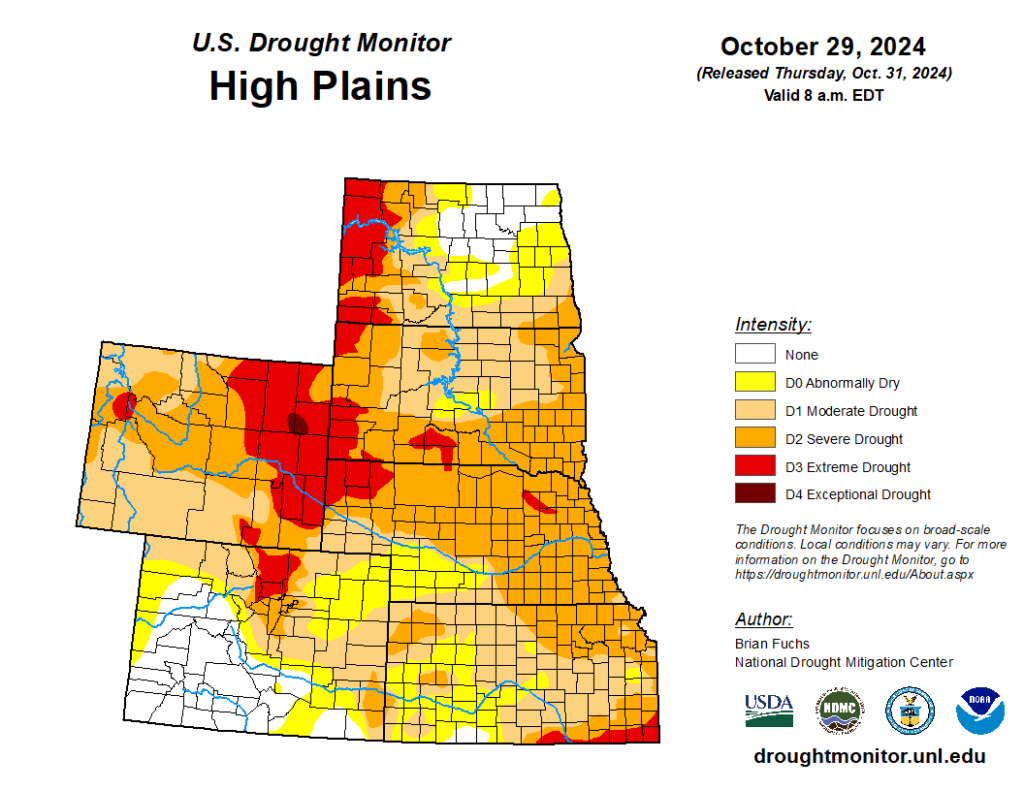
Heavy precipitation, particularly in Kansas and eastern Colorado, helped ease drought conditions this month. For the most part, only improvements were made in November. Overall, the region observed a decrease of over 9 percent in abnormally dry to exceptional drought conditions (D0 to D4).
Kansas benefitted greatly from the precipitation, with up to 3 categories of improvement this month. Extreme drought (D3) and severe drought (D2) were eliminated, while moderate drought (D1) was reduced by nearly 46 percent in the state. Soil moisture and winter wheat have also responded positively to the influx of moisture.
Colorado also experienced widespread improvements this month. Drought conditions across the eastern part of the state were significantly reduced, with only D0 remaining. The pocket of D3 near Fort Collins remains but has shrunk significantly. Elsewhere in the region, other improvements and degradation were observed. According to the Climate Prediction Center’s U.S. Monthly Drought Outlook for December, drought conditions may improve in northwestern Wyoming.
Department of Agriculture (USDA), National Drought Mitigation
Center, U.S. Department of Commerce, and the National Oceanic and
Atmospheric Administration (NOAA). For current Drought Monitor
information, please see: http://droughtmonitor.unl.edu/
Climate Outlooks
According to the Climate Prediction Center, ENSO-neutral conditions are present. A La Niña watch is currently in effect. For more information, visit https://www.cpc.ncep.noaa.gov/products/analysis_monitoring/lanina/enso_evolution-status-fcsts-web.pdf
The National Weather Service’s long-range flood outlook indicates minimal chances of flooding along the Missouri River through February. According to the National Interagency Fire Center (NIFC), fire potential will be near normal through March.
The seasonal temperature and precipitation outlook presented below combine the effects of long-term trends, soil moisture, and when applicable, the El Niño Southern Oscillation (ENSO). To learn more about these outlooks, please visit http://www.cpc.ncep.noaa.gov.
Temperature
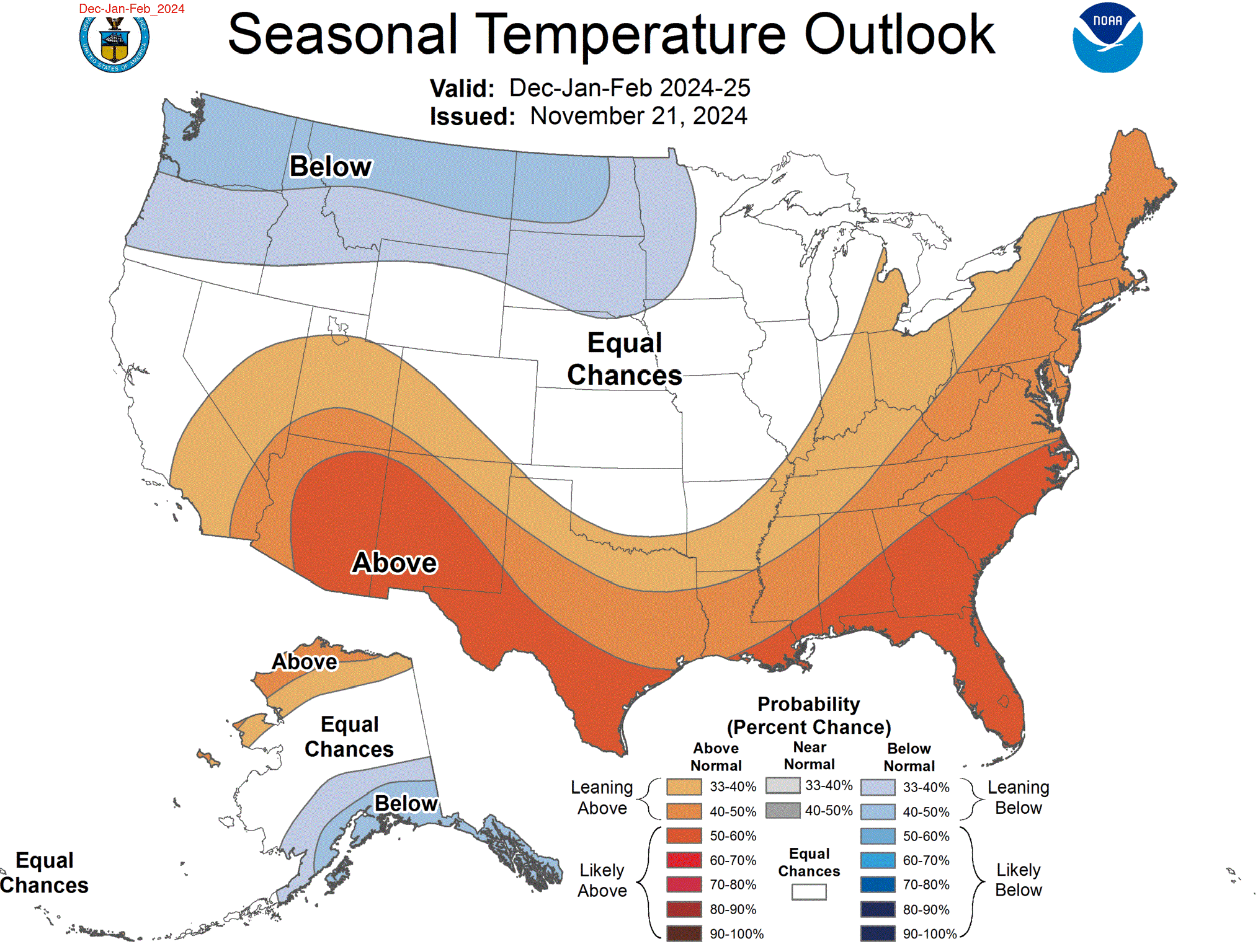
The three-month temperature outlook shows an increased chance of above-normal temperatures across the much of the southern and eastern United States, while below-normal temperatures are favored across the northern parts. Above-normal temperatures are possible in western Colorado and below-normal temperatures are favored in the Dakotas.
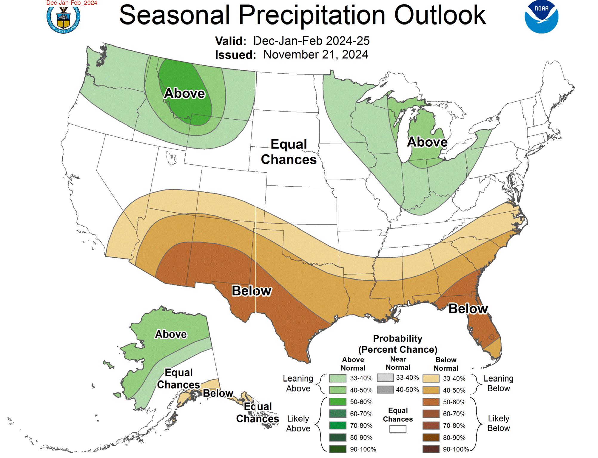
Precipitation
The outlook for the next three months indicates below-normal precipitation across the southern United States, while above-normal is possible in the northwest and Great Lakes. Below-normal precipitation is possible in Colorado and Kansas, while above-normal is possible in Wyoming.
Drought
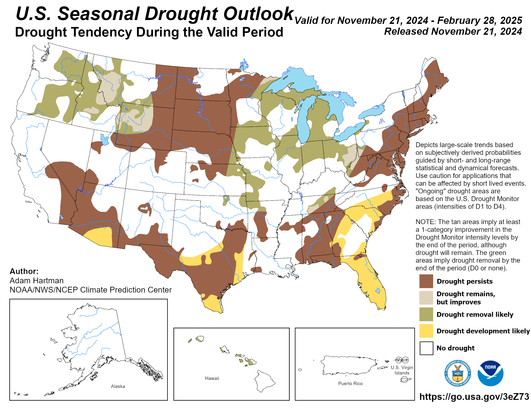
The U.S Seasonal Drought Outlook released on November 30th indicates that drought improvements are possible in Kansas, Nebraska, and Wyoming.
Station Summaries: By the Number
Download PDF Below