

August 2024 Climate Summary
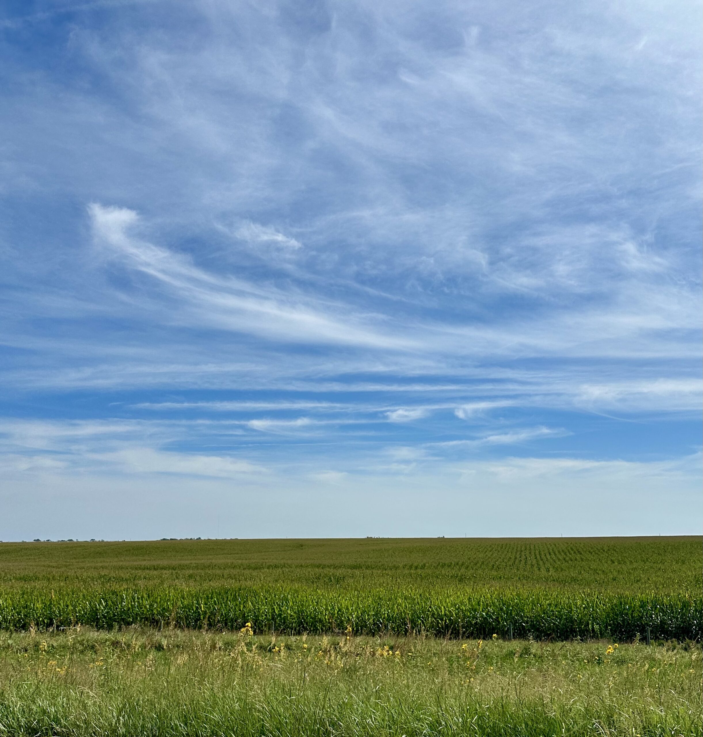
Corn in central Nebraska, Photo Courtesy of Gannon Rush
Regional Breakdown
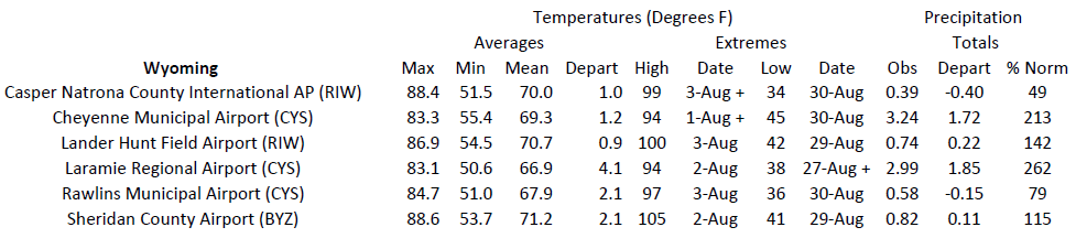
The heat that impacted the northwestern part of the region in July spread south this month, with nearly the entire western half of the High Plains experiencing above-normal temperatures. Parts of Colorado and Wyoming skyrocketed over 100 degrees F (37.8 degrees C), with areas above 6500 feet (1981 meters) even passing the century mark.
While severe weather was relatively quiet for the region outside of Colorado, several notable events occurred this month. On the 25th, a microburst from a surprise storm occurred during an air show at McConnell Air Force Base in Wichita, Kansas, leaving 10 injured and canceling a performance by the Blue Angels. In Wyoming, Devil’s Tower was pummeled by 2.75-inch (6.99 cm) hail and caused significant damage. The National Park Service was forced to close the monument for two days due to the destruction.
Colorado was the epicenter of unusual weather this month. Early in the month, an EF1 tornado with 100 mph (161 km/h) winds carved a 0.92 mile (1.48 kilometers) long path near Pikes Peak. At 10,050 feet (3063 meters), tornadoes do not normally form at such high elevations. Later in the month, the nearby town of Cascade was buried beneath a deep layer of hail. So much had fallen, that it caused a layer of “hail fog” to form.
Precipitation and Water Resources
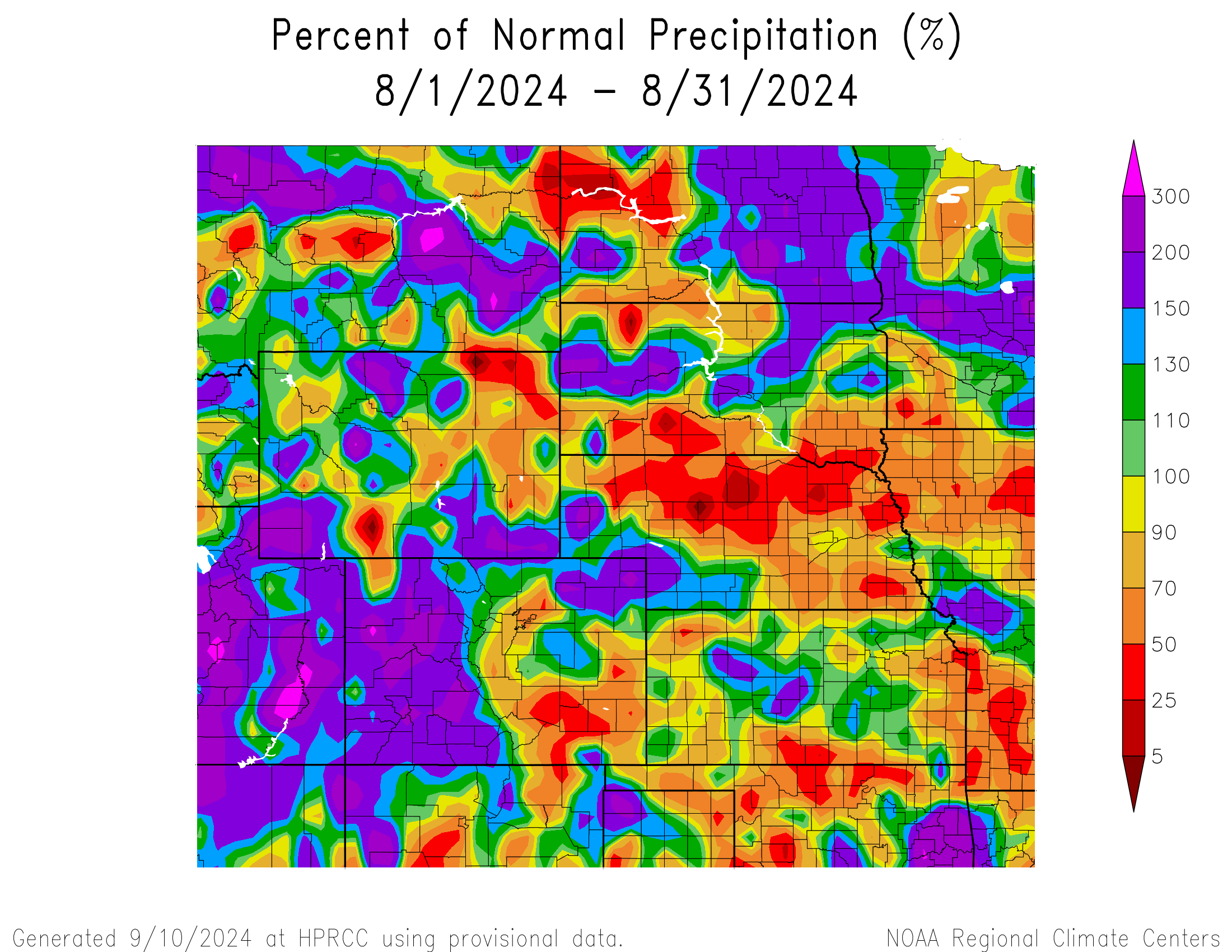
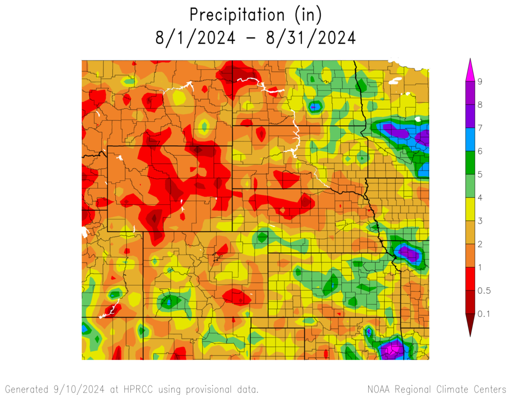
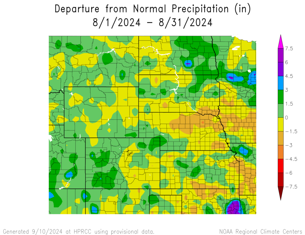
Precipitation in August was plentiful west of the Rockies this month, with the North American Monsoon in overdrive for western Colorado and into southern Wyoming. Kansas and Nebraska were not as fortunate, with large portions of both states with below normal precipitation.
Concerns about drought in western Colorado were increasing at the beginning of the month, however, monsoon rains alleviated those concerns. Monte Vista observed their wettest August and their wettest month on record, with 4.44 inches (11.28 cm) of rain. Altenbern crushed their record for August and was just short of the all-time monthly record, with 5.26 inches (13.36 cm) of rain. Several Snow Telemetry (SNOTEL) stations in the higher elevations also recorded their wettest August. Multiple stations across the western part of the state also recorded their wettest summer, further highlighting the impact of the monsoon this year.
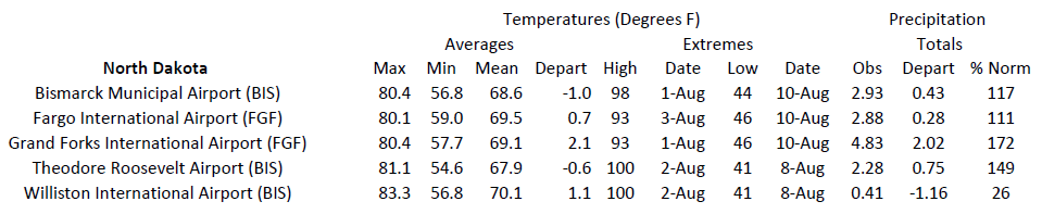
Outside of Colorado, a few other places received record to near-record amounts of rain this past month. Parts of eastern North Dakota surpassed their monthly precipitation records, with soil moisture percentiles above 95 percent at the end of the month in the area.
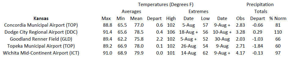
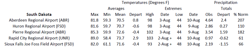
With the end of summer, some were more fortunate than others. Dodge City, Kansas recorded its third wettest and most summertime rain totals since 1889, with 17.75 inches (45.09 cm). To the south in Colorado, Alamosa tied with 2017 for the 8th wettest with 4.44 inches (11.28 cm). Eastern Wyoming and western South Dakota were below 50 percent of their normal precipitation this summer. Rapid City ranked 5th driest, with only 2.87 inches falling through the end of August. In Wyoming, Cody recorded less than an inch (2.54 mm) the entire summer.
Streamflow at the end of August was above normal across eastern North Dakota and the southern parts of Colorado due to the heavy precipitation this month. On the flip side, streamflow was much below normal in eastern Kansas and Nebraska where drought is beginning to take its toll.
Temperatures
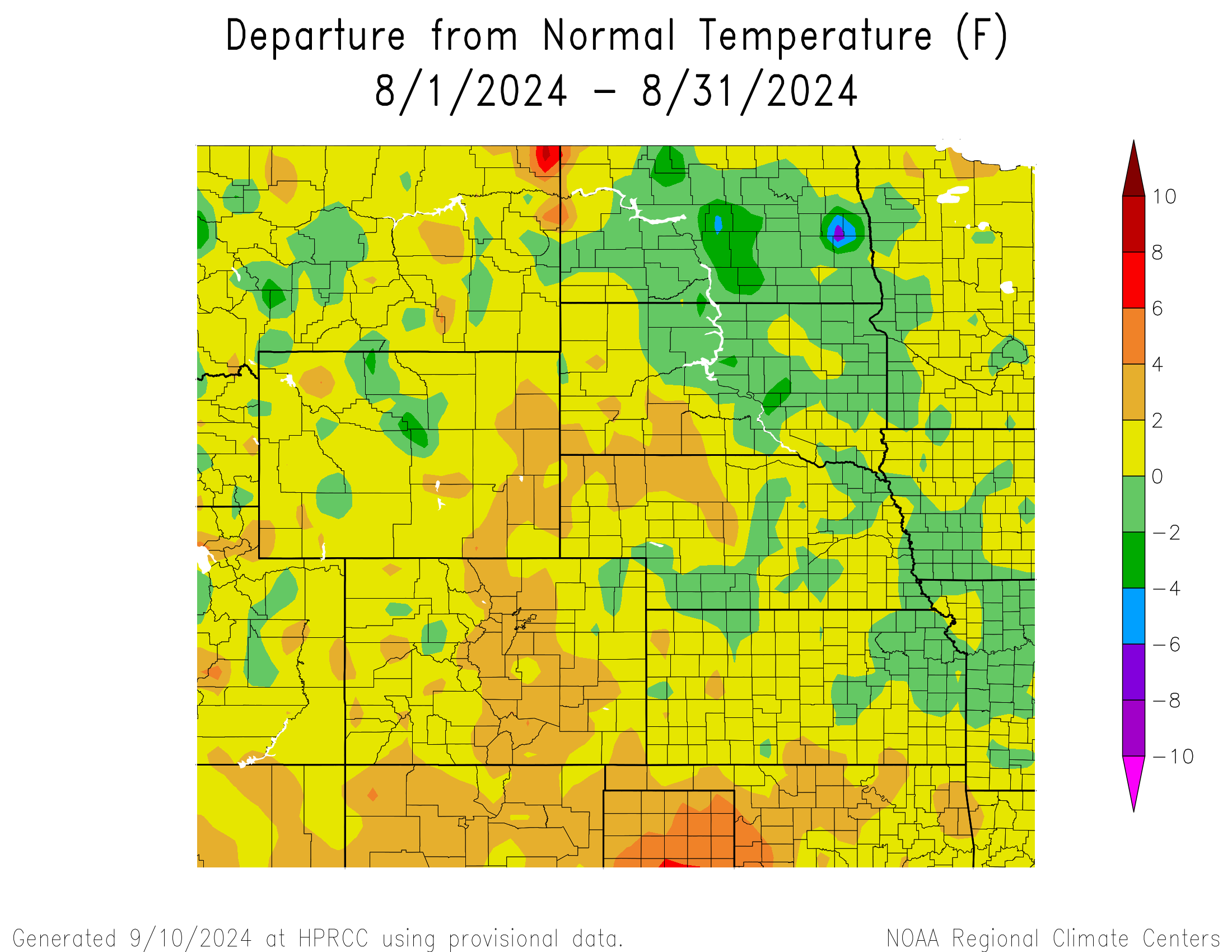
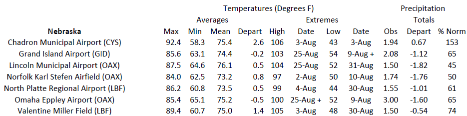
Temperatures were near normal for much of the region this month. Parts of the Dakotas were slightly below normal, while the Front Range into western Nebraska experienced warmer than normal temperatures.
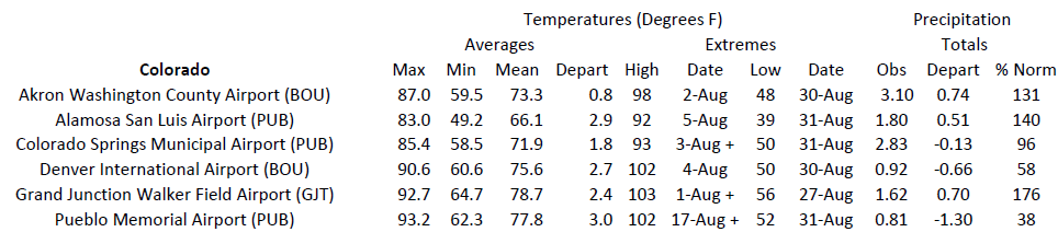
Several locations in the west ranked in the top 10 warmest this month, with Alamosa, Colorado just barely breaking their record. The average temperature was 66.1 degrees F (18.9 degrees C), narrowly topping the previous record of 66.0 degrees F (18.9 degrees C). To the east, Denver ranked 4th warmest, while Pueblo ranked 7th and Colorado Springs tied for 8th. In southeastern Wyoming, Laramie recorded their 2nd warmest August and fell just short of the record set in 2020.
Aided by a prolonged stretch of heat in the West, many locations ranked in the top 5 warmest this summer. In Colorado, Grand Junction broke its record with an average temperature of 80.1 degrees F (26.7 degrees C). Alamosa and Denver ranked 2nd, while Colorado Springs tied with 2021 for 4th. To the north in Wyoming, Laramie broke its record and nearby Rawlins tied with 2022 for 5th. Elsewhere in the region, locations in Nebraska and South Dakota ranked in the top 10.
Drought Conditions
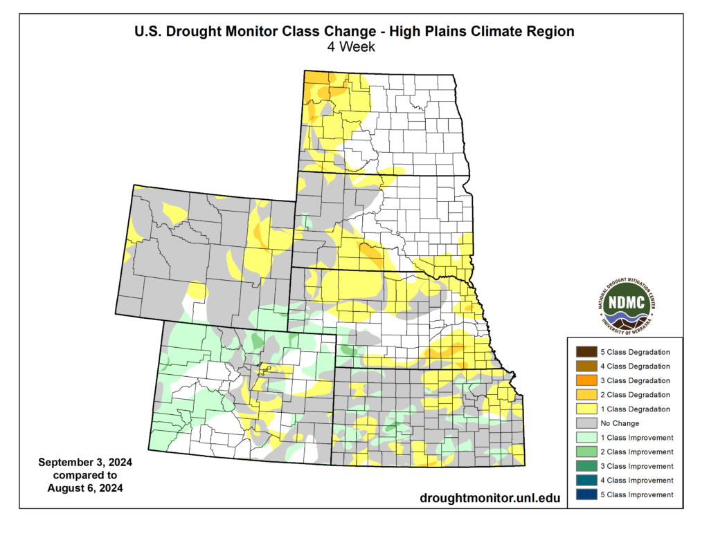
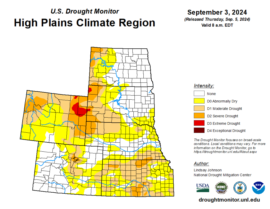
Outside of the beneficial rains in Colorado and parts of Kansas, much of the region was dry and drought intensified as a result. Several states experienced a two-category degradation, while the areas that did receive rain improved by two categories. Overall, the region observed an increase of over 13 percent in D0 to D4 (abnormally dry to exceptional drought conditions).
Wyoming was hit hardest this month, with extreme drought (D3) introduced and expanded in the northeastern part of the state. Large fires broke out in the state due to persistent dryness and 96 percent of the state is abnormally dry at the end of August.
While parts of Kansas did see improvement, the state observed a 14 percent increase in drought conditions, and 50 percent of the state is being impacted. The north and south-central parts of the state currently have several counties in severe drought (D2), leading to concerns for winter wheat planting.
Elsewhere in the region, other improvements and degradation were observed. According to the Climate Prediction Center’s U.S. Monthly Drought Outlook for August, drought conditions will expand in along the Nebraska and South Dakota border
Department of Agriculture (USDA), National Drought Mitigation
Center, U.S. Department of Commerce, and the National Oceanic and
Atmospheric Administration (NOAA). For current Drought Monitor
information, please see: http://droughtmonitor.unl.edu/
Climate Outlooks
According to the Climate Prediction Center, ENSO-neutral conditions are present. A La Niña watch is currently in effect. For more information, visit https://www.cpc.ncep.noaa.gov/products/analysis_monitoring/lanina/enso_evolution-status-fcsts-web.pdf
The National Weather Service’s long-range flood outlook indicates increased chances of Minor Flooding along the Missouri River through November. According to the National Interagency Fire Center (NIFC), fire potential will be elevated in Wyoming and South Dakota in September.
The seasonal temperature and precipitation outlook presented below combine the effects of long-term trends, soil moisture, and when applicable, the El Niño Southern Oscillation (ENSO). To learn more about these outlooks, please visit http://www.cpc.ncep.noaa.gov.
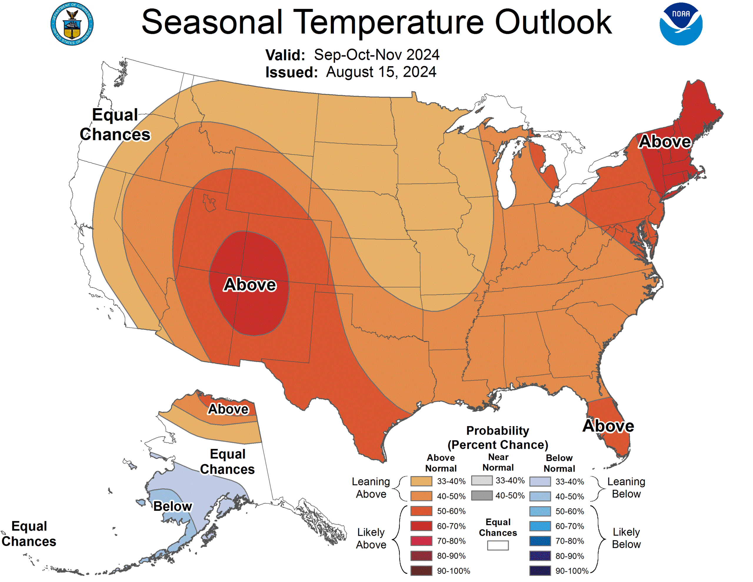
Temperature
The three-month temperature outlook shows an increased chance of above-normal temperatures across the much of the United States. Above-normal temperatures are possible across the entire High Plains, with Colorado heavily favored.
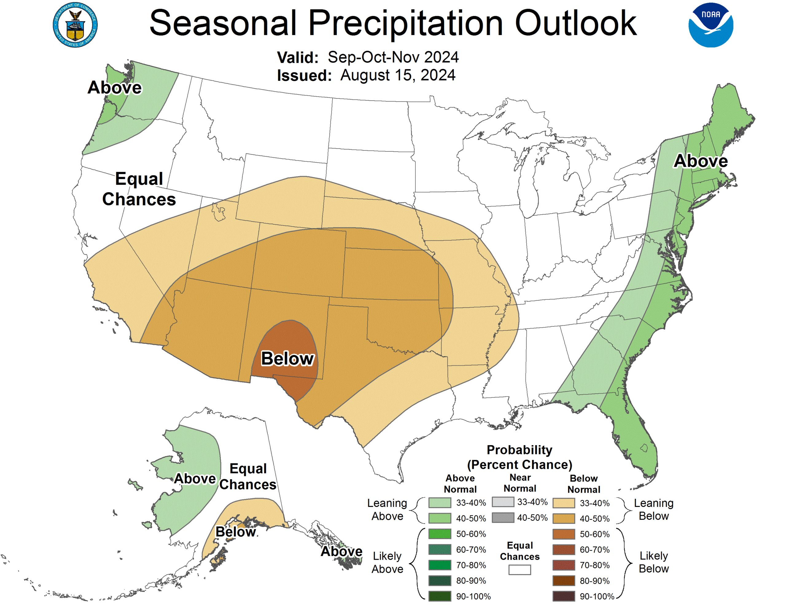
Precipitation
The outlook for the next three months indicates below-normal precipitation across the west-central United States, while above-normal is possible in the east. Below-normal precipitation is possible in nearly every state in the High Plains.
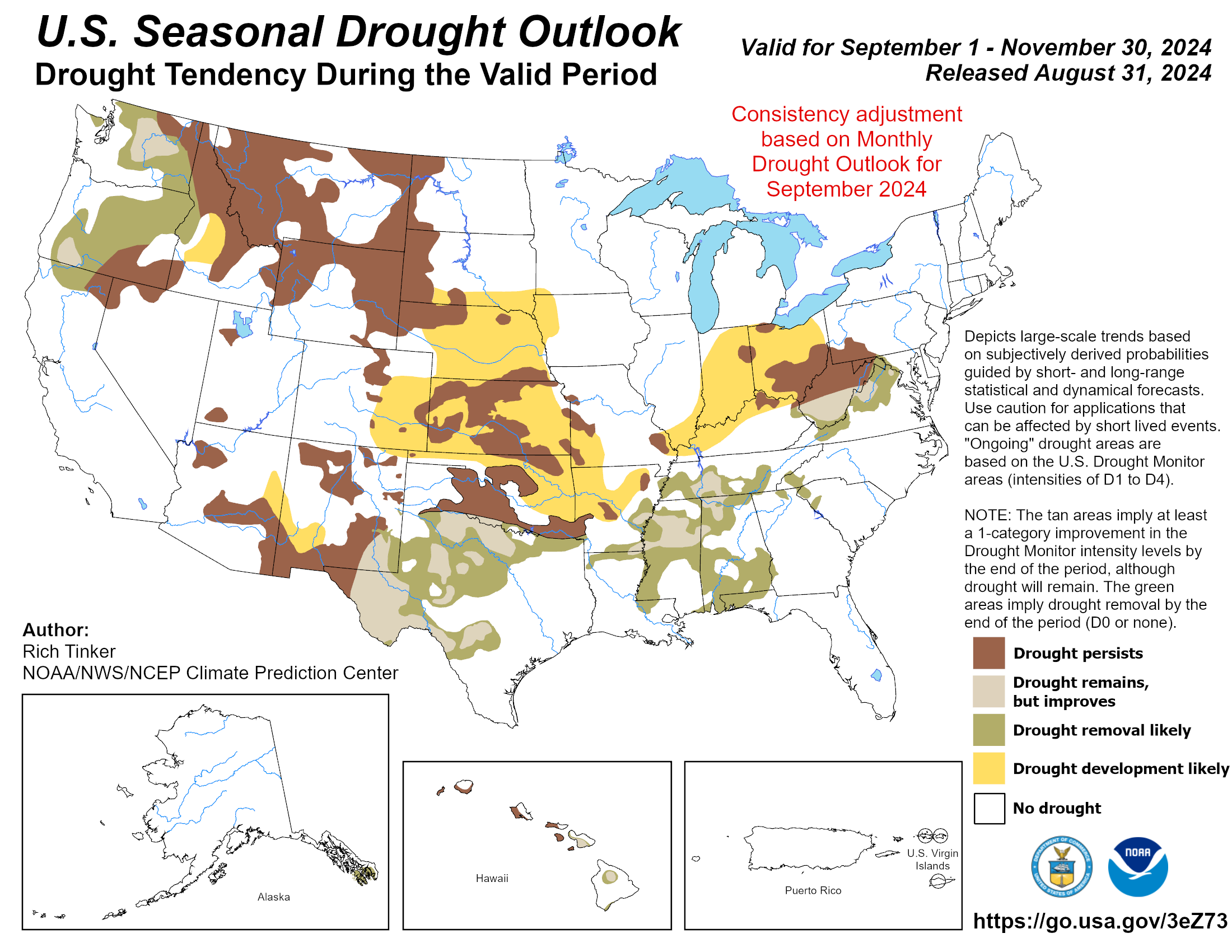
Drought
The U.S Seasonal Drought Outlook released on August 31st indicates that drought development and expansion is likely throughout the southern High Plains.
Station Summaries: By the Number
Download PDF Below