

July 2024 Climate Summary
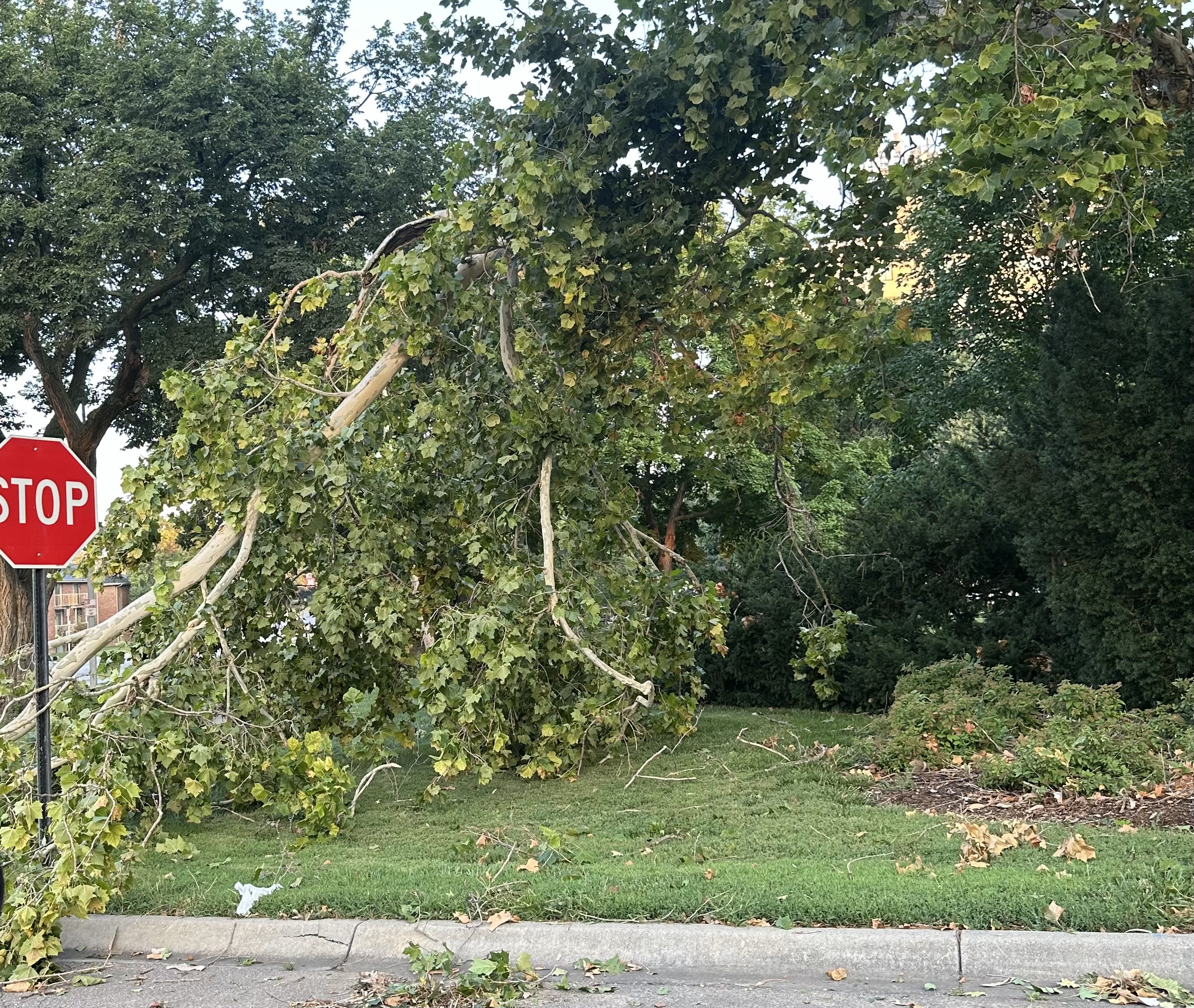
Storm Damage in Lincoln, Nebraska, Photo Courtesy of Gannon Rush
Regional Breakdown
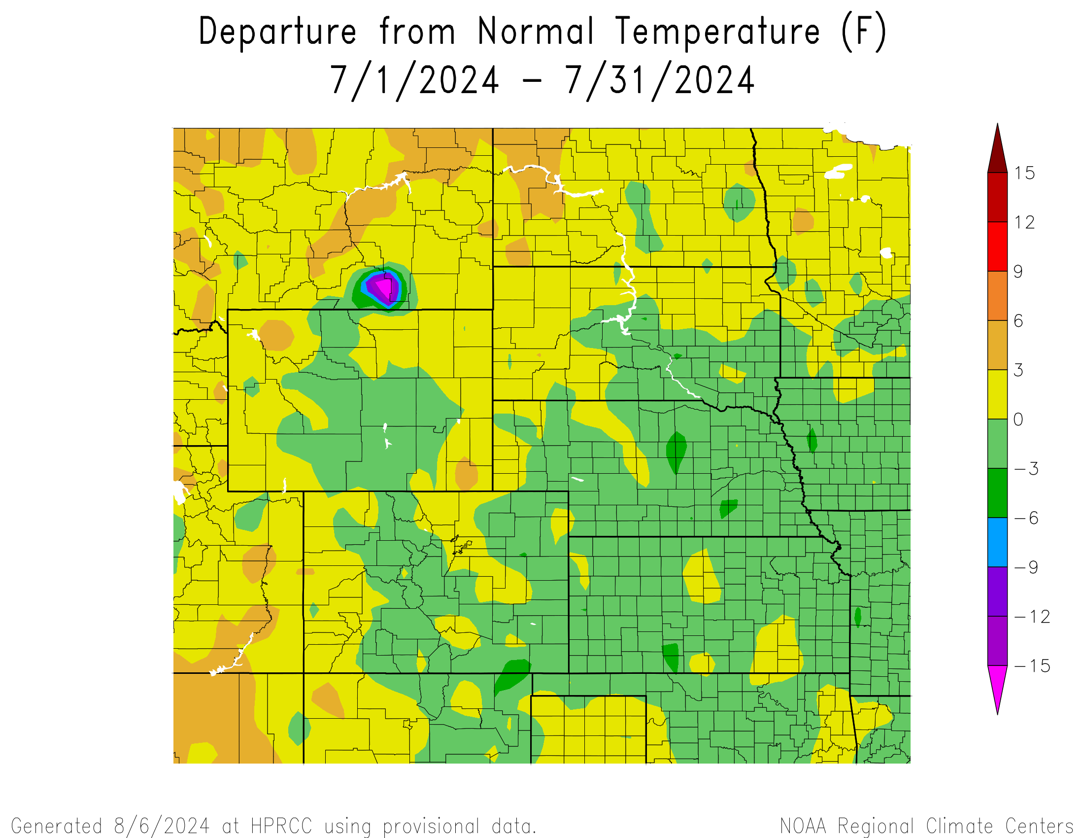
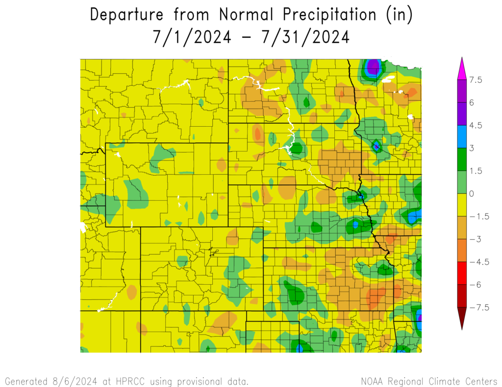
After staying relatively cool over the past two months, the north and northwestern parts of the High Plains were boiling hot this month. Average high temperatures this month in parts of Montana, the Dakotas, and Wyoming were above 90 degrees F (32.2 degrees C), with several bouts of extreme heat striking. Typical of the summertime months, precipitation was sporadic and often brought severe weather.
The places within the region that did receive rain this month were hampered by severe weather, with several devastating hailstorms striking this month. This month’s hardest hit places were central and eastern Nebraska, southwestern Kansas, and southeastern Colorado. Corn was in great shape in central Nebraska, with minimal irrigation taking place due to the ample precipitation this year. A nasty storm on the 6th annihilated thousands of acres in a stretch from Gothenburg to Hastings. Wind gusts of over 70 mph (112 km/h) and hailstones over 2.5 inches (6.35 cm) shredded fields for over 100 miles. An untold amount of damage occurred and left farmers facing a tough situation going forward.
The heat impacting the northern and western parts of the region was not just limited to the lower elevation, with parts of Yellowstone National Park in Wyoming having record stretches of warmth. Parkers Peak observed its hottest 7 and 14-day stretches on record this month, with temperatures peaking at 86 degrees F (30 degrees C) on the 24th. At 9,400 feet (2.87 km) above sea level, such a temperature is very rare.

Precipitation and Water Resources
For the most part, the High Plains were dry this month and some places were below five percent of their normal precipitation. The storms this month, particularly in Nebraska, were impactful with extreme winds and large hail.
July began with several damaging hailstorms in Nebraska but was relatively quiet until the last day of the month. Extreme winds of over 90 mph (145 km/h) shredded Lincoln and Omaha, with over 250,000 without power. Roughly half of Omaha was without power, the largest outage in the history for the city. The exceptional wind gusts caused extensive tree damage and even structural damage to several businesses and schools. Estimates for the damage will come in the following weeks, but it was likely one of the most expensive storms for Omaha.
The dryness across the Front Range in Colorado finally took its toll, with numerous wildfires breaking out late in the month. Precipitation in the area has been below 50 percent for the past few months, leaving plenty of dried-up fuel for fires. Evacuations were ordered and thick clouds of smoke engulfed cities like Fort Collins. Thousands of acres were in flames at the end of the month, but the arrival of monsoonal rains could provide some relief.
Streamflow at the end of the month was mixed, with some gauges well-above normal and others at near record levels. Central Kansas and southern Nebraska were below normal, with several locations at record lows. Areas near the Missouri River were near normal, while eastern North Dakota was above the 90th percentile.

Temperatures
Despite the presence of a brutal heatwave this month, temperatures were near normal. Parts of western North Dakota were the warmest, with average temperatures 3 to 6 degrees F (1.7 to 3.3 degrees C) above normal.
An extended stretch of heat hit the northwestern part of the region, including Montana. Many places recorded their longest streaks of 90 degrees F (32.2 degrees C), while the heat carried over into parts of the Dakotas and Wyoming. Highs reached near 110 degrees F (43.3 degrees C) in parts of North Dakota, nearly breaking some all-time records.
Limiting the overall temperature was the cooler start to July. Temperatures were over 10 degrees (5.6 degrees C) below normal to start the month in parts of the region. The 4th of July was pleasant for many, with some places 15 degrees F (8.3 degrees C) below normal.
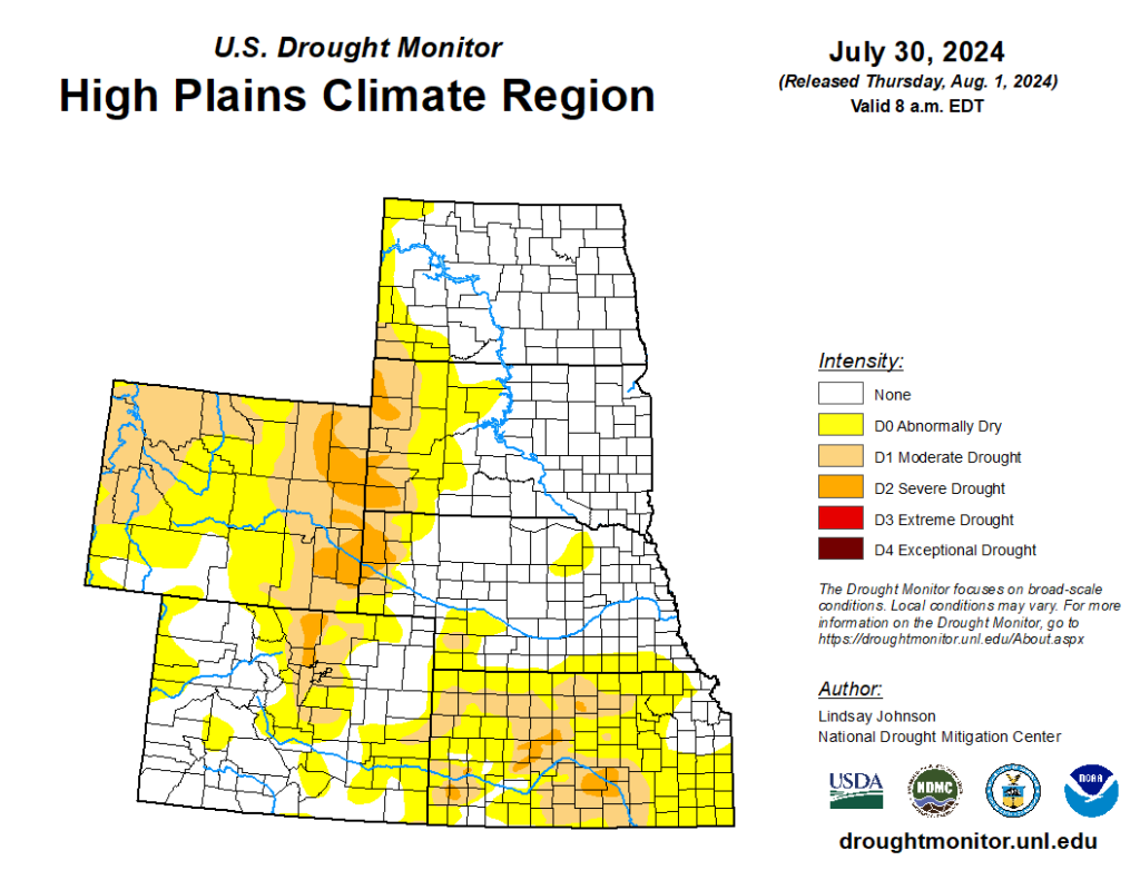
Drought Conditions
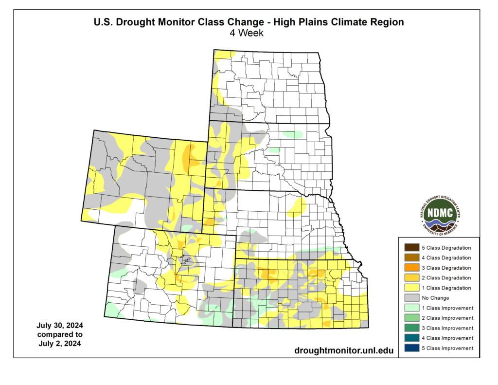
In part due to the dryness and occasional heat this month, drought expanded and intensified for many. Portions of the southern High Plains experienced a two-category degradation, while over half the region is now in some form of drought category. Overall, the High Plains observed an 11 percent increase in D0 to D4 (abnormally dry to exceptional drought conditions).
The dryness plaguing Wyoming has led to a nine percent increase in D2 (severe drought), with most of this along the state’s eastern border. Nearly the entire state is in D0 to D4, but there is some hope that upcoming rains due to the North American Monsoon could help improve the ongoing situation.
Conditions in Kansas had improved this winter and into early spring, however, the state has taken a step back this month. D0 to D4 increased over 34 percent this month alone, with nearly 90 percent of the state engulfed at the end of July.
Elsewhere in the region, other improvements and degradation were observed. According to the Climate Prediction Center’s U.S. Monthly Drought Outlook for August, drought conditions will expand in Kansas, the Dakotas, and Wyoming.
Department of Agriculture (USDA), National Drought Mitigation
Center, U.S. Department of Commerce, and the National Oceanic and
Atmospheric Administration (NOAA). For current Drought Monitor
information, please see: http://droughtmonitor.unl.edu/
Climate Outlooks
According to the Climate Prediction Center, ENSO-neutral conditions are present. A La Niña watch is currently in effect. For more information, visit https://www.cpc.ncep.noaa.gov/products/analysis_monitoring/lanina/enso_evolution-status-fcsts-web.pdf
The National Weather Service’s long-range flood outlook indicates high chances of Minor Flooding along the Missouri River through September. According to the National Interagency Fire Center (NIFC), fire potential will be near normal through November.
The seasonal temperature and precipitation outlook presented below combine the effects of long-term trends, soil moisture, and when applicable, the El Niño Southern Oscillation (ENSO). To learn more about these outlooks, please visit http://www.cpc.ncep.noaa.gov.
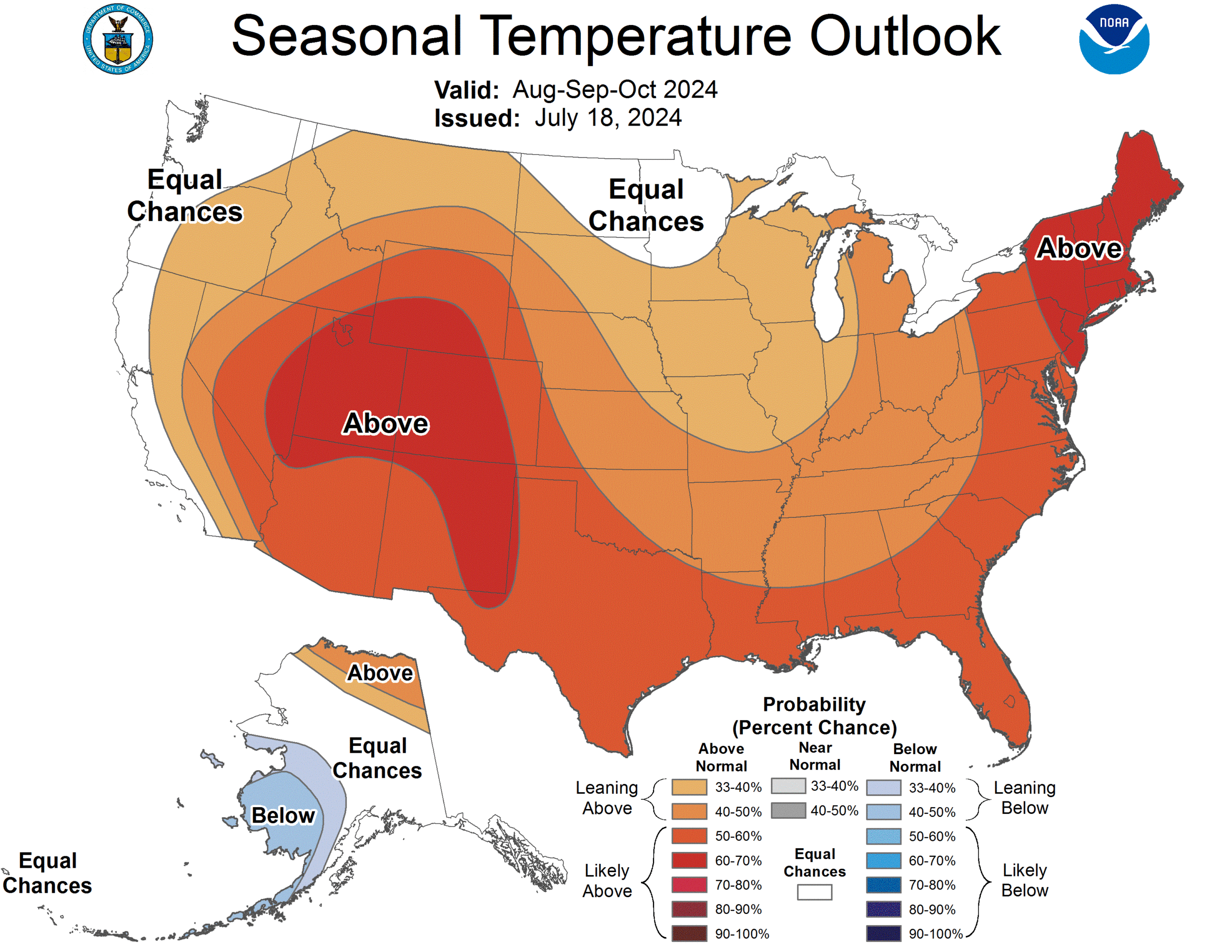
Temperature
The three-month temperature outlook shows an increased chance of above-normal temperatures across the much of the United States. Above-normal temperatures are possible across the entire High Plains, with Colorado heavily favored.
Precipitation
The outlook for the next three months indicates below-normal precipitation across the west-central United States, while above-normal is possible in the east. Below-normal precipitation is possible in nearly every state in the High Plains.

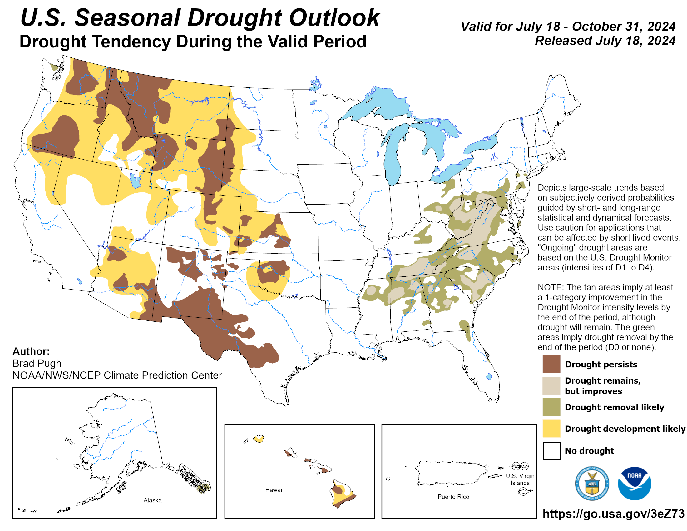
Drought
The U.S Seasonal Drought Outlook released on July 18th indicates that drought development and expansion is likely in nearly every state.
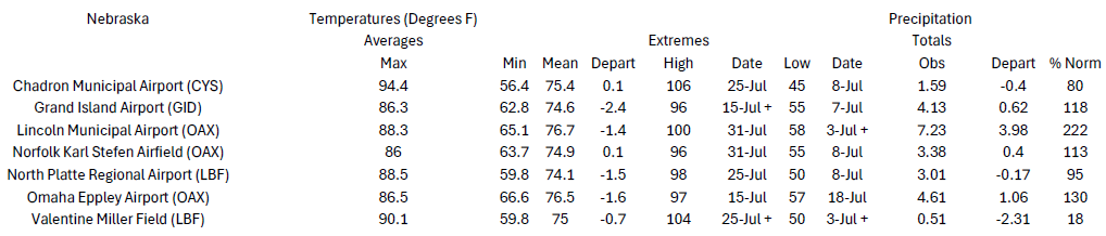
Station Summaries: By the Number

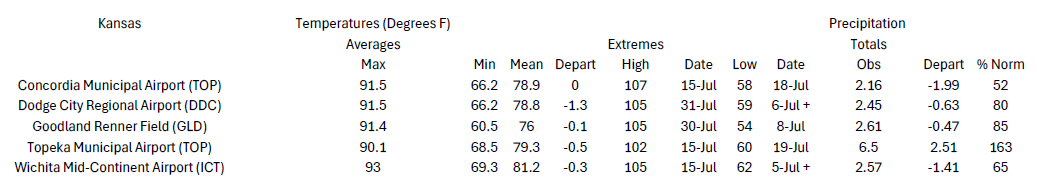


Download PDF Below