

June 2024 Climate Summary
Sunny Day in Central Nebraska, Photo Courtesy of Gannon Rush
Regional Breakdown
June began on a cooler note, but temperatures rapidly rose during the middle of the month. Winter wheat harvest also began in Kansas this month, with mixed reports on yields due to ill-timed dryness and severe weather. In South Dakota, several rounds of heavy precipitation led to flooding within the state and along the Missouri River and into parts of Kansas.
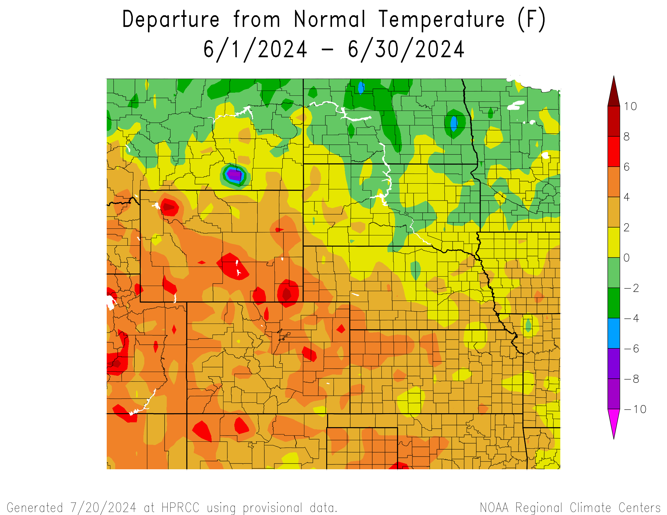
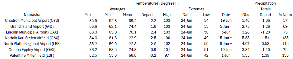
The month began on the cool side, with highs near 50 degrees F (10 degrees C) for parts of South Dakota and Wyoming. Temperatures flipped in the coming days, with both states experiencing temperatures exceeding 100 degrees F (37.8 degrees C). A significant heatwave spread across the High Plains late in the month, with heat indices peaking near 115 degrees F (46.1 degrees C) in eastern Nebraska.
Winter wheat in Kansas was feast or famine for some farmers this year, with some producers reporting yields of nearly 60 bushels per acre more than last year while others had none and had to rely on insurance. After much of Kansas received over 150 percent of its normal precipitation this winter, there was optimism that yields could be significantly better. The faucet was turned off for much of the western part of the state at the end of February, leading to a rapid return of drought conditions. When moisture did return, hail and straight-line winds accompanied it and wreaked havoc on the weakened crop.
Tremendous amounts of rain fell in Sioux Falls, South Dakota area on the 21st and 22nd. Over 12 inches (30.48 cm) fell near the town of Canton, annihilating the 2-day total precipitation state record by close to 3 inches (7.62 cm). I-29 was closed near Sioux City to build a levee and prevent further flooding, while a train bridge connecting South Dakota to Iowa over the Big Sioux River collapsed due to the waters. The attempt to build a levee near Sioux City inadvertently caused tremendous damage to the town of McCook Lake, just north of Sioux City. Massive sinkholes formed and homes and roads were swept away as the floodwaters rapidly rose. Areas downstream were being affected at the end of the month, with the true extent of the damage not fully known.
Precipitation and Water Resources
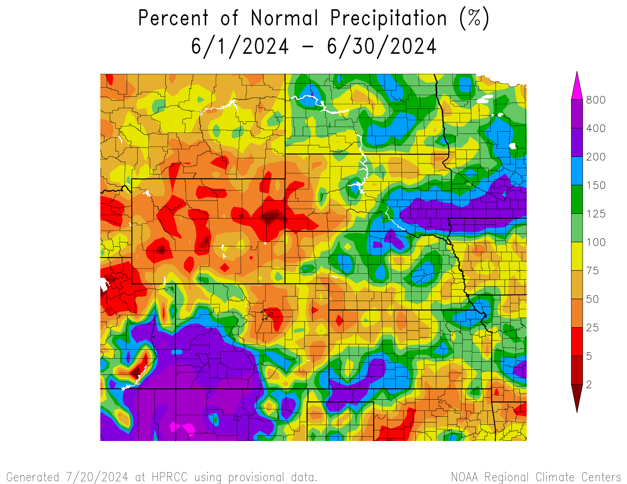
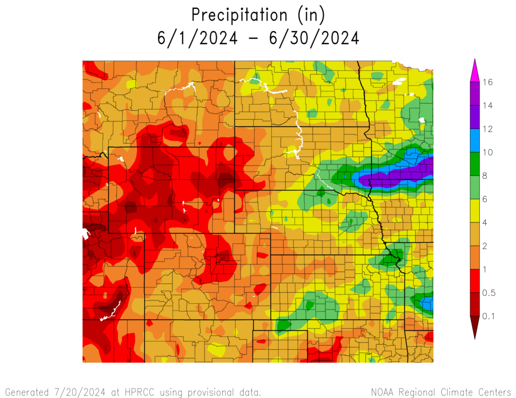
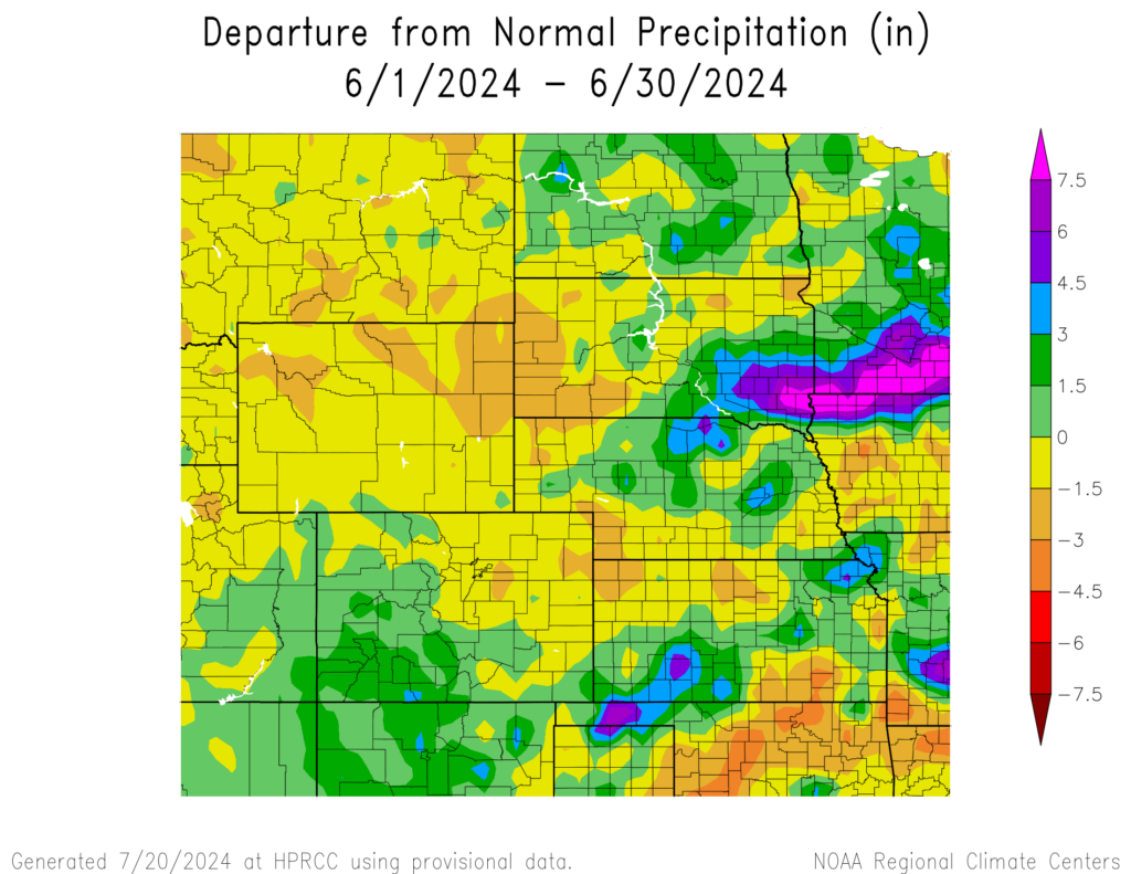
Precipitation was scattered but mainly occurred in the eastern part of the High Plains this month. Wyoming missed nearly everything, with some areas with near zero precipitation. Southwestern Colorado was well above normal, potentially hinting that the North American monsoon had begun.
Although Wyoming is typically drier this time of the year, June was nearly bone dry for parts of the state. Several areas received less than 0.10 inches (2.54 mm), which combined with the warm temperatures, led to the intensification of drought conditions. With the outlooks favoring warmer and drier conditions for upcoming months, conditions in the state will need to be monitored.
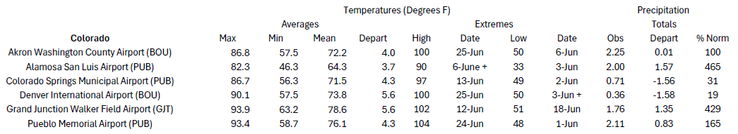
Several rounds of precipitation impacted southwestern Colorado this month, leading some areas to record their wettest month. Major locations like Alamosa and Grand Junction fell just short, ranking 2nd and 3rd respectively. On the opposite side of the Rockies, cities like Denver were not as fortunate and were nearly in the top 10 driest.
After recording their 3rd driest spring with 1.77 inches (4.50 cm) of precipitation, the situation looked gloomy in Dodge City, Kansas. The month of June flipped that script, with 12.02 inches (30.53 cm) of rain. Not only did this set a new record for the wettest June, but it also ranked as the 2nd wettest month on record. Due to how much rain fell, Dodge City needs only near-normal precipitation for July and August to record their wettest summer.
The active severe weather season continued into June, with over 1,000 reports of severe weather. Wind gusts reached 97 mph (156 km/h) near Burlington, Colorado, and North Platte, Nebraska early in the month, while a 90 mph (145 km/h) wind gust impacted Eppley Airfield in Omaha, Nebraska. Tornado activity calmed down this month, however, a strong tornado struck western Nebraska on the 25th. A preliminary EF3 with 160 mph (258 km/h) winds touched down in Grant County near Whitman and continued into nearby Hooker County. It is the first EF2+ tornado to strike Grant County in nearly 70 years. This same storm also produced exceptionally large hail, with stones reaching up to 4 inches (10.16 cm). Just across the border in Wyoming, stones reached up to 4.5 inches (11.43 cm) just a few days earlier.
Streamflow remained in very good shape across the region except for central Kansas. In the eastern part of the region, streamflow in the Missouri River was near or at record level at the end of May and created concerns about flooding. The heavy precipitation late in the month in South Dakota has led to record highs and flooding along the Missouri River.
Temperatures
Warmer temperatures dominated the southern and western part of the High Plains, while North Dakota was slightly below normal this month. Areas in Colorado and Wyoming were over 6 degrees F (3.3 degrees C) above normal, predominantly due to the heatwave that impacted those states this month. During this stretch of heat, the thermometer passed 100 degrees F (37.8 degrees C) in both states.
Wyoming observed record to near-record warmth, especially in the southeastern part of the state. Cheyenne narrowly broke their record for the warmest June, while Laramie easily surpassed theirs. To the west, Rawlins ranked 2nd and Lander tied 2016 for 5th warmest.
To the south in Colorado, the state was also heavily impacted by the extended stretch of heat. Many of the major locations such as Alamosa, Colorado Springs, Grand Junction, and Denver ranked 2nd warmest this month. A total of 9 stations in Colorado recorded their warmest June including Estes Park, Grand Lake, and Limon.
Drought Conditions
June was a mixed bag for drought conditions, with a reduction in intensity but an expansion in coverage. The biggest changes occurred in Wyoming and Kansas this month, while the region observed a 12 percent increase in D0 to D4 (abnormally dry to exceptional drought conditions).
Western and central Kansas headed into summer in rough shape, with D3 (extreme drought) being reintroduced to the area. The heavy precipitation this month helped alleviate conditions, with up to 2 categories of improvement. Another round of storms impacted the Dodge City area towards the end of the month, which will likely lead to further improvements.
Record to near-record warmth and bone-dry conditions in Wyoming led to the rapid expansion of drought in the state. D0 expanded over 39 percent across the central and northern parts of the state, while a stretch of D1 (moderate drought) increased across the eastern border.
Elsewhere in the region, other improvements and degradation were observed. According to the Climate Prediction Center’s U.S. Monthly Drought Outlook for July, drought conditions will expand in Kansas, South Dakota, and Wyoming.


Department of Agriculture (USDA), National Drought Mitigation
Center, U.S. Department of Commerce, and the National Oceanic and
Atmospheric Administration (NOAA). For current Drought Monitor
information, please see: http://droughtmonitor.unl.edu/
Climate Outlooks
According to the Climate Prediction Center, ENSO-neutral conditions are present. A La Niña watch is currently in effect. For more information, visit https://www.cpc.ncep.noaa.gov/products/analysis_monitoring/lanina/enso_evolution-status-fcsts-web.pdf
The National Weather Service’s long-range flood outlook indicates high chances of Major Flooding in Nebraska and South Dakota along the Missouri River through September. According to the National Interagency Fire Center (NIFC), fire potential will be elevated in eastern Colorado and western Kansas in July and August.
The seasonal temperature and precipitation outlook presented below combine the effects of long-term trends, soil moisture, and when applicable, the El Niño Southern Oscillation (ENSO). To learn more about these outlooks, please visit http://www.cpc.ncep.noaa.gov.
Temperature
The three-month temperature outlook shows an increased chance of above-normal temperatures across the much of the United States. Above-normal temperatures are possible across the entire High Plains, with western Colorado heavily favored.

Precipitation
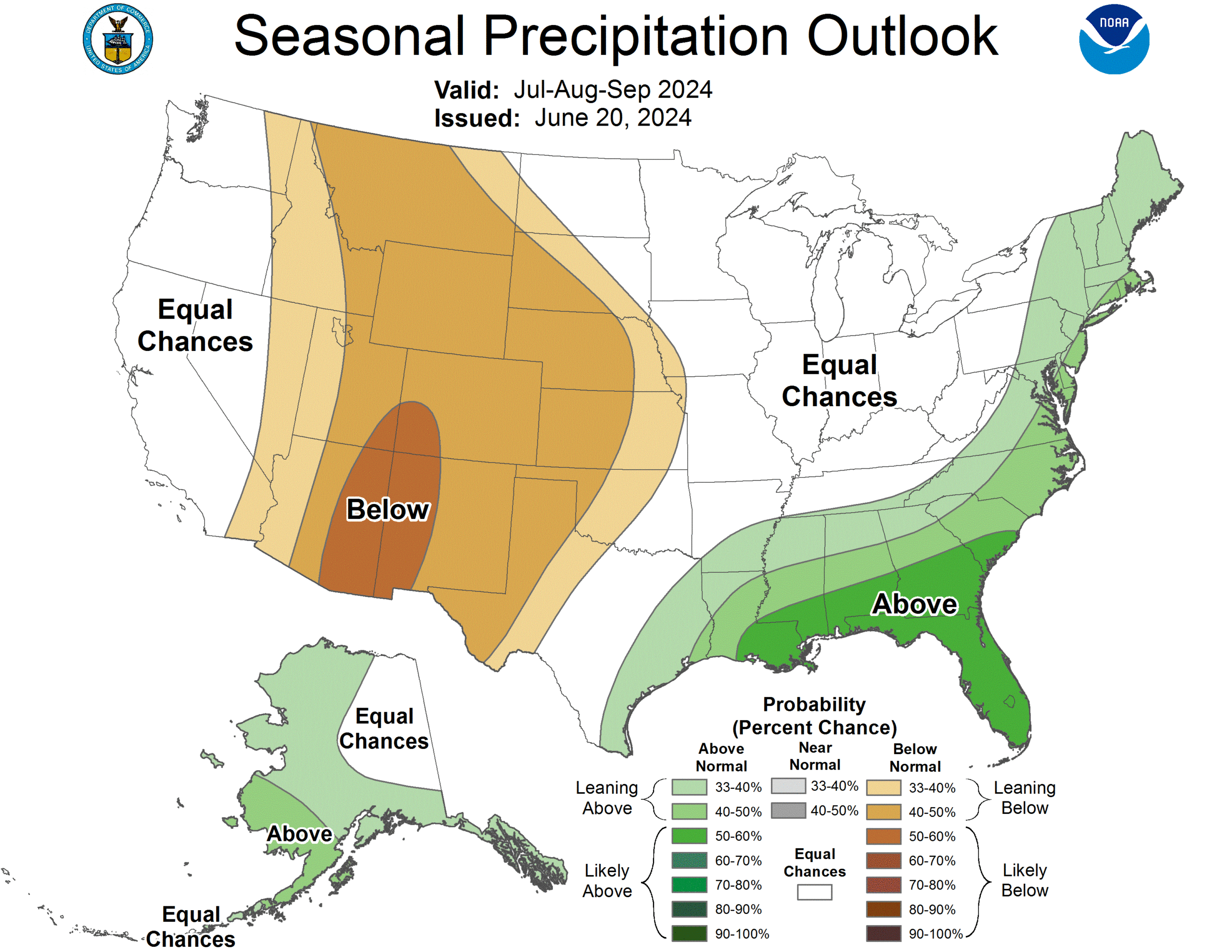
The outlook for the next three months indicates below-normal precipitation across the west-central United States, while above-normal is possible in the east. Below-normal precipitation is possible in nearly every state in the High Plains.
Drought
The U.S Seasonal Drought Outlook released on June 30th indicates that drought development and expansion is likely in nearly every state.

Station Summaries: By the Number


Download PDF Below