Temperature
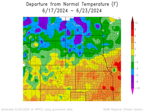
This week featured above normal temperatures for the southern half of the region and below normal temperatures for the northern half of the region. The warmest region was southeastern Kansas with temperatures 6°F to 8°F above normal. The coldest region was central North Dakota and northern South Dakota with temperatures of 5°F to 8°F below normal.
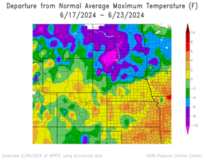
Maximum temperatures varied across the region. Southeastern Kansas and a spot in eastern Colorado reached temperatures 4°F to 6°F above normal. The warmest temperature was 93°F at the Lamar Municipal Airport in Colorado, 3°F above normal, and Chanute Airport in Kansas, 5°F above normal. Temperatures in North Dakota and South Dakota reached 5°F to 10°F below normal, with spots in both states reaching 11°F above normal.
Minimum temperatures were 4°F to 6°F below normal in North Dakota and Wyoming, with temperatures reaching 6°F to 8°F below normal. The coldest temperature was 35°F at Jackson, Wyoming, which is 4°F below normal. Temperatures in Kansas, a spot in southeastern Wyoming and southern Colorado reached 6°F to 8°F above normal.

Precipitation
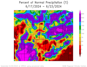
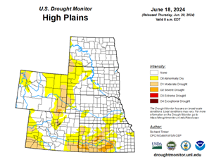
Precipitation amounts varied this week, ranging from 2% of normal precipitation for southeastern Kansas, northwestern Wyoming, and the Colorado-Kansas-Nebraska border to 800% of normal precipitation in southwestern Colorado and eastern South Dakota. Canton, South Dakota received 13.82 inches of rain, well above their normal of 0.15 inches; most of this fell on June 21st. Drought continues in the region. D0 (abnormally dry) across the region was up from 31% to 35%. In the region, Nebraska experienced the highest decrease in D0 conditions with a 2% decrease while South Dakota experienced the highest increase in D0 conditions with a 13% increase.
Severe Storms
North Dakota received hail with diameter of 1 inch. Colorado and South Dakota received hail with diameters between 1 to 1.75 inches. Kansas and Wyoming received hail with diameters between 1 to 2 inches and 1 to 4 inches respectively. Nebraska received hail with diameters between 1 to 3 inches, and Scotts Bluff saw EF-1 tornado damage. South Dakota continues to experience flooding causing damage and road closures.
