January 2024 Climate Summary
View of Snowy Range in Wyoming, Photo Courtesy of Gavin Rush
Regional Breakdown
The run of scalding hot temperatures stretching back to September finally ended this month, and winter arrived with a vengeance. Temperatures dipped below zero, while wind chills plummeted. Several rounds of snow pushed through the southern portions of the region, but the northern parts were nearly bone-dry.
Temperatures were mild during the first week of the month before a front packed with arctic air and heavy snowfall trekked south. Up to 12 inches (30.48 cm) of snow fell in parts of Nebraska on the 8th, while air temperatures fell to –30 degrees F (-34.4 degrees C) at Old Faithful at Yellowstone National Park in Wyoming. The thermometer continued to drop across the region, with thousands of daily and over 30 all-time records broken at the end of this arctic blast. Light winds were also present for several days, creating life-threatening wind chills nearing –65 degrees F (-53.9 degrees C) in North Dakota.
After a steady warmup, the month ended on a bright note with temperatures rising to over 60 degrees F (15.6 degrees C) for many. Not only did this provide a reprieve from the absurdly cold temperatures, but it also melted away the snow and ice in the region.


Precipitation and Water Resources
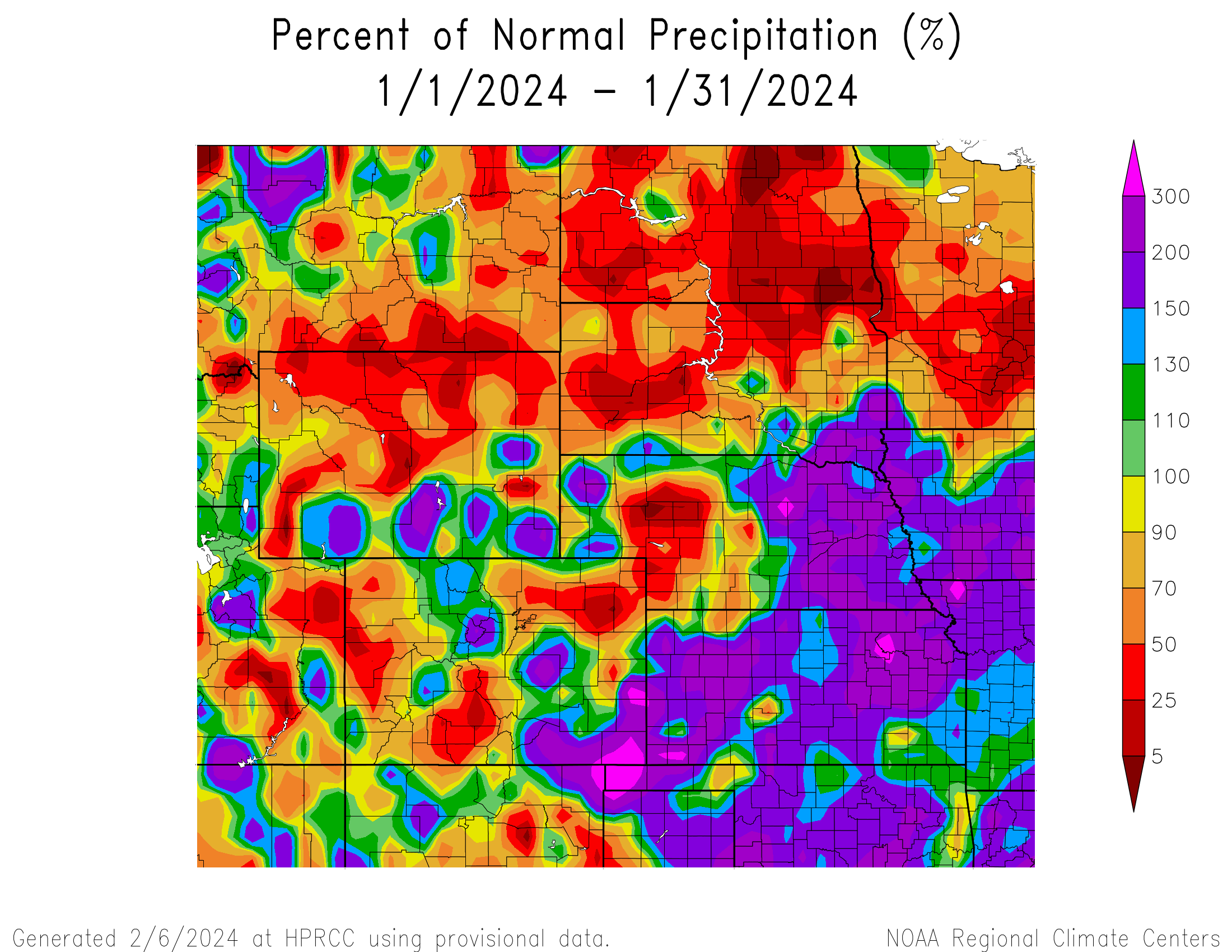
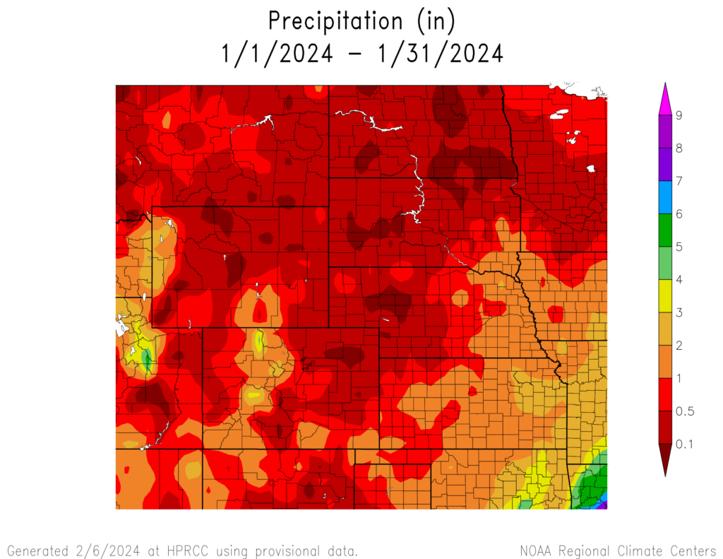
A one-two punch impacted Kansas and Nebraska this month, while the rest had spotty precipitation. The Dakotas and northern Wyoming were near bone-dry, with parts of those states receiving less than 0.10 inches (2.54 mm) of precipitation this month.
Winter arrived with a vengeance in Kansas and Nebraska. A moderate amount of snow fell on the 8th and the 9th, but the gut punch occurred on the 12th. Nearly a foot (30.48 cm) of snow fell in parts of Nebraska, while temperatures plummeted below zero. Roads rapidly turned into icy nightmares, with hundreds of wrecks reported. At the end of the month, several major locations ranked in the top 10 for January snowfall. Norfolk, Nebraska nearly broke their monthly record, with 20.6 inches (52.32 cm) of snow, while a CoCoRaHS observer near Columbus reported a whopping 31 inches (78.74 cm) this month.
Outside of the southeastern corner of South Dakota, the Dakotas largely missed any form of precipitation this month. Fargo, North Dakota recorded their 6th lowest January snowfall while other parts of the state recorded a mere dusting.
In the west, Colorado and Wyoming had isolated patches of above-normal precipitation but also significant dryness. Akron, Colorado only measured 0.01 (0.254 mm) of precipitation, ranking third driest and Cody, Wyoming received trace amounts to tie for fourth driest.
At the end of January, snowpack was in decent shape for most of Colorado and average to poor in Wyoming. Much of the snow this year has fallen in the plains and not the mountains. The extreme cold created ice jams in the rivers, however, the warmer temperatures at the end of the month have helped clear out some of the jams.


Temperatures
Temperatures were below normal for most of the region, due to the arctic blast in the middle of the month. Despite the cold, the southwestern and northeastern parts of the region experienced departures of over 4 degrees F (2.2 degrees C) above normal. Even with the variability, very few locations ranked in the top 10 warmest or coldest this month.
The warmth from the back half of 2023 carried into the opening days of 2024, with temperatures reaching up to 57 degrees F (13.9 degrees C) in Kansas on the 4th. That would be the last glimmer of hope as much of the region plunged into below-freezing temperatures for almost two weeks. High temperatures dropped all the way to –25 degrees F (-31.7 degrees C) outside of Williston, North Dakota, and subzero highs stretched all the way to Kansas. The peak of this cold spell occurred on the 14th when hundreds of daily records were broken. After suffering through this, temperatures steadily rose until the end of the month.
The unbearable cold didn’t impact some in the region, and Grand Junction, Colorado was among them. It was their 6th warmest January on record, with an average temperature of 34.8 degrees F (1.6 degrees C). High temperatures reached 60 degrees (15.6 degrees C) twice this month, which is highly unusual since it has only happened three times since records began in 1893.
Drought Conditions
The continued above-normal precipitation in Kansas and eastern Nebraska over the past 90 days has tremendously improved the drought situation, while conditions have deteriorated in the northern portions of the region due to low snowfall. Despite this increase, the region experienced a reduction of nearly 6 percent in D0 to D4 (abnormally dry to exceptional drought conditions).
Drought conditions have improved significantly in Kansas since the beginning of the water year, with a 40 percent reduction in D2 to D4 (severe to exceptional drought) due to several timely bouts of precipitation. The same can be said for eastern Nebraska, where the intensity of drought conditions has been reduced immensely. On the opposite end of the spectrum, snowfall has been hard to come by in northern Wyoming, with drought degrading up to 3 classes this month. Elsewhere in the region, other improvements and degradation were observed. According to the Climate Prediction Center’s U.S. Monthly Drought Outlook for February, drought conditions will improve in Kansas and western Colorado.


Department of Agriculture (USDA), National Drought Mitigation
Center, U.S. Department of Commerce, and the National Oceanic and
Atmospheric Administration (NOAA). For current Drought Monitor
information, please see: http://droughtmonitor.unl.edu/
Climate Outlooks
According to the Climate Prediction Center, El Niño conditions are likely to continue but transition towards ENSO-neutral in mid to late Spring. An El Niño advisory is currently in effect. For more information, visit https://www.cpc.ncep.noaa.gov/products/analysis_monitoring/lanina/enso_evolution-status-fcsts-web.pdf
The National Weather Service’s long-range flood outlook indicates elevated chances of Minor Flooding in the eastern parts of Kansas and South Dakota through the end of April. According to the National Interagency Fire Center (NIFC), fire potential will be limited across the region through May.
The seasonal temperature and precipitation outlook presented below combine the effects of long-term trends, soil moisture, and when applicable, the El Niño Southern Oscillation (ENSO). To learn more about these outlooks, please visit http://www.cpc.ncep.noaa.gov.
Temperature
The three-month temperature outlook shows an increased chance of above-normal temperatures across the northern United States. Above-normal temperatures are slightly favored in the Dakotas and Wyoming.

Precipitation
The outlook for the next three months indicates below-normal precipitation across the Pacific Northwest and the Great Lakes, while above-normal precipitation is favored for the eastern United States and portions of the Plains. Above-normal precipitation is slightly favored in Kansas, Nebraska, and parts of Colorado and South Dakota.

Drought
The U.S Seasonal Drought Outlook released on January 31st indicates that improvements to drought conditions will continue in Kansas, Nebraska, and western Colorado over the next three months.

Station Summaries: By the Number


Download PDF Below


