Regional Significant Events for September – November 2023

Highlights for the Basin
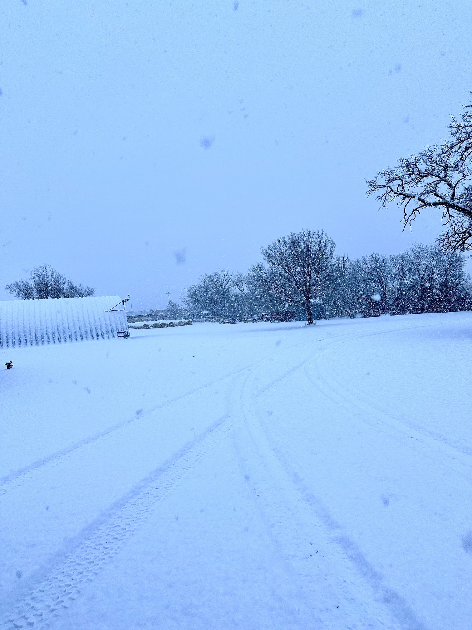
Eastern Kansas was pummeled by a snow storm on Thanksgiving weekend.
A number of cities like Wichita received more snow from this single event than all of last winter. It was the largest November snowstorm for Wichita since 1906.
Very heavy rains fell across portions of Nebraska, Kansas, and South Dakota
in October. Record monthly single-day rainfall fell on October 12th near Ewing,
NE (7.39”) and the following day near Fairfax, SD (5.90”). On October 25th over 9” fell near Osage City, KS, but only minor flooding was reported due to very dry conditions.
Arctic air and gusty winds sent a shock through the Basin around Halloween.
Subzero temperatures were recorded in the northern Basin, while single-digit
lows reached all the way to Kansas.
Regional Climate Overview for September – November 2023
Temperature and Precipitation Anomalies
Warmer temperatures dominated the region, with cooler temperatures arriving
for short periods at the end of October and November. Minimum temperatures were well above normal throughout the entire region this fall. Two heatwaves impacted the region on Labor Day weekend and the first week of October, breaking hundreds of records in the process.
After above-normal precipitation in September and October in parts of the
basin, conditions dried out significantly in November. Multiple counties along
the Nebraska and South Dakota border ranked in the top five wettest this fall
due to the heavy rains in October. To the south, several counties in eastern
Colorado and western Kansas ranked in the top five driest.
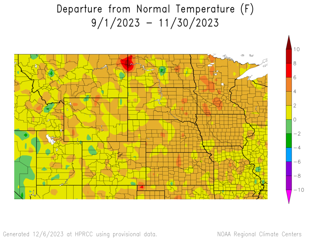
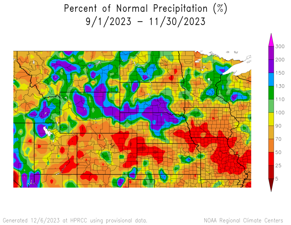
and Percent of Normal Precipitation (bottom) for the Fall of 2023
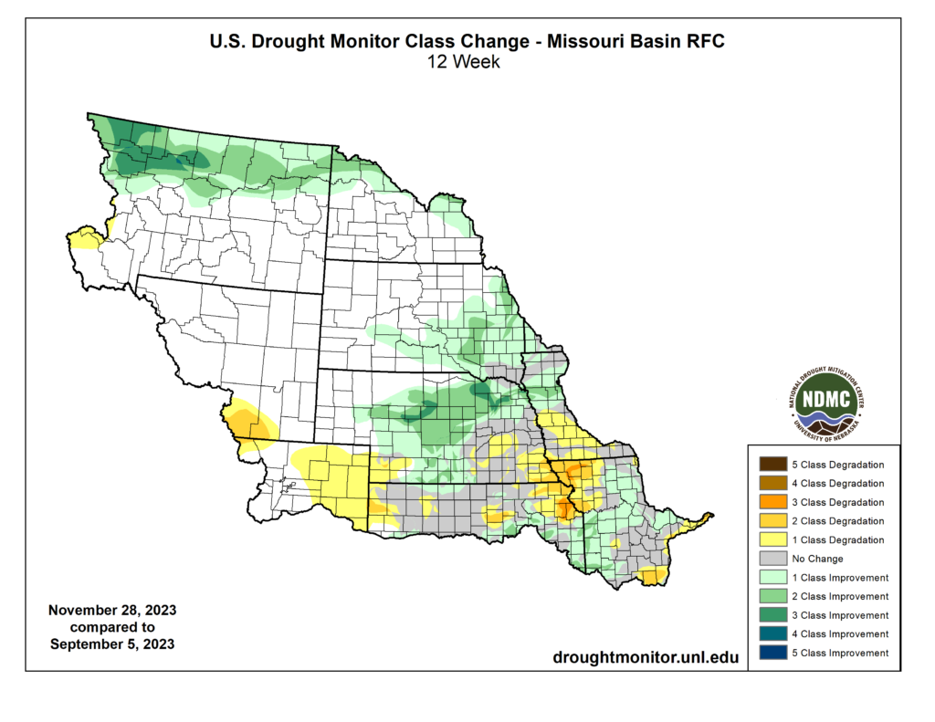
Changes in Drought Conditions
The map above shows the areas of increasing and decreasing drought.
Green shading indicates where drought improved and yellow shading shows were conditions degraded over the fall. Drought conditions improved up to four categories this fall across northern Montana and North Dakota, while dryness intensified in northeastern Kansas and northwestern Missouri.
September 5 to December 5, 2023
Regional Impacts for September – November 2023
Agriculture
Warm and dry conditions led to optimal conditions for harvest. A hard freeze with record low temperatures at the end of October finally ended the growing season for most crops. The same conditions that were conducive to harvest were not ideal for winter wheat, with 32 percent rated poor to very poor in Kansas. Heavy precipitation in October greatly improved soil moisture in South Dakota and northern Wyoming. On the opposite end of the spectrum, the dryness that has plagued portions of Kansas, Missouri, and Nebraska this fall has left soils dry heading into the winter months.
Transportation
The winter storms on the weekends of Halloween and Thanksgiving greatly impacted travel conditions throughout the basin. Travel across Colorado was greatly hampered on October 29th after up to 10 inches of snow fell. Over 100 flights were canceled and over 700 delays at Denver International Airport. Two people died same day due to traffic accidents along I-80 in Nebraska. Heavy snow on the 24th and 25th of November led to chaos for those traveling on the holiday weekend. 1500 flights were delayed in Denver, while hundreds of wrecks were reported throughout the lower Missouri River basin.
Regional Outlook for December 2023 – February 2024
According to NOAA’s Climate Prediction Center, the outlook for the upcoming
season follows a typical El Niño pattern with warmer temperatures and below-normal precipitation favored across the northern Basin. Above-normal precipitation is slightly favored in Colorado, Kansas, and Nebraska, which would help replenish dry soils in those states. The rest of the Basin has
equal chances of above, below, and near-normal precipitation.
The continued dry weather and potential for lack of snowfall can lead to an
elevated risk of wildfires and impact wheat growth this winter. An ENSO blog
from NOAA Climate details the impact that El Niño can have on snowfall this
winter.
Temperature
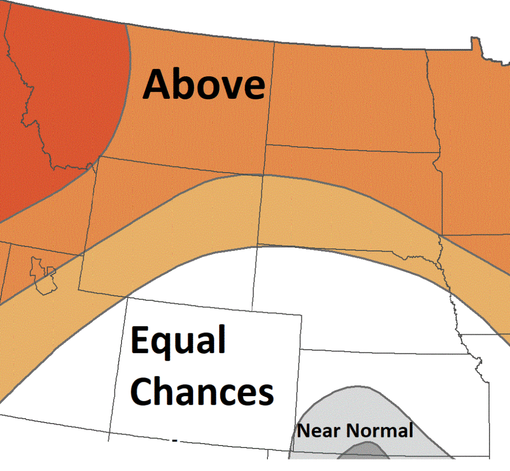
A: Above normal, B: Below normal
Precipitation
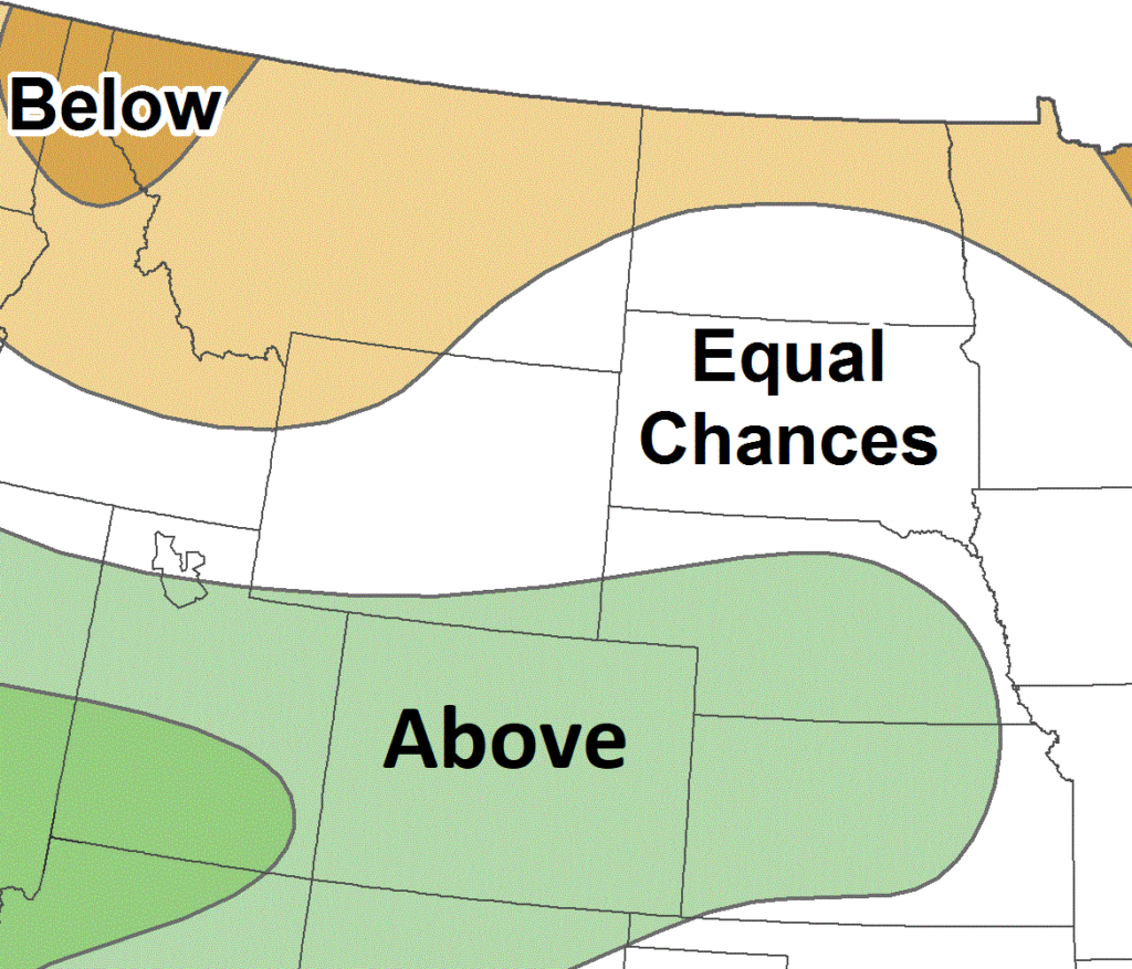
A: Above normal, B: Below normal
MO River Basin Partners
High Plains Regional Climate Center
www.hprcc.unl.edu
National Drought Mitigation Center
http://drought.unl.edu/
National Integrated Drought Information System
https://www.drought.gov/
NOAA NCEI
www.ncdc.noaa.gov
NOAA NWS – Central Region
www.weather.gov/crh
NOAA NWS Climate Prediction Center
www.cpc.ncep.noaa.gov
NOAA NWS Missouri Basin River Forecast Center
www.weather.gov/mbrfc
American Association of State Climatologists
https://www.stateclimate.org/
U.S. Army Corps of Engineers
www.nwd-mr.usace.army.mil/rcc/
U.S. Bureau of Reclamation
https://www.usbr.gov/
USDA Natural Resources Conservation Service
www.nrcs.usda.gov
USDA Northern Plains Climate Hub
www.climatehubs.oce.usda.gov
Bureau of Indian Affairs – Great Plains Region
www.bia.gov/regional-offices/great-plains
Download PDF below