November 2023 Climate Summary
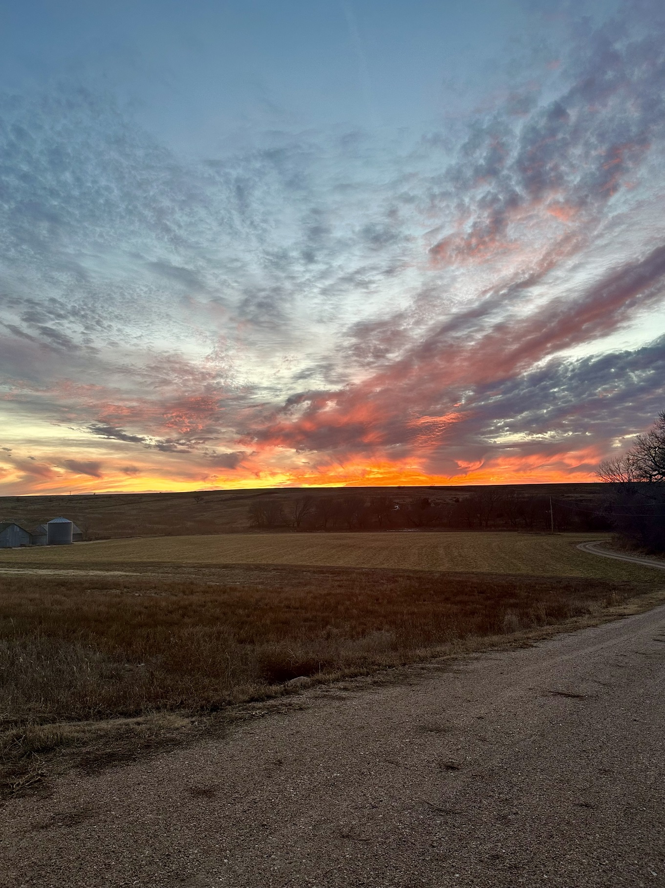
Snowfall in Western Kansas, Photo Courtesy of Gannon Rush
Regional Breakdown
In a similar pattern to October, warmer temperatures dominated until a late-month shot of cool air and snow on Thanksgiving weekend led to serious impacts. Outside of the heavy snowfall in some places associated with this system, the region was extremely dry.
The Thanksgiving weekend storm impacted at the worst possible time during the peak of traveling. Hundreds of wrecks occurred, with over 400 reported in the state of Kansas alone. Cities like Manhattan, Topeka, and Wichita all received more snowfall in one storm than the entirety of last year. The last time Wichita received this much snow in a single November storm was over 100 years ago in 1906. In Nebraska, three people died in separate crashes in the central part of the state, and over 100 wrecks were reported in the city of Lincoln alone. Further west, Wyoming experienced numerous wrecks after over 20 inches (50.8 cm) of snow fell in some places. Denver International Airport was significantly impacted once again, with over 1,500 flights delayed during a weekend where nearly 700,000 people were traveling through the airport.


Precipitation and Water Resources
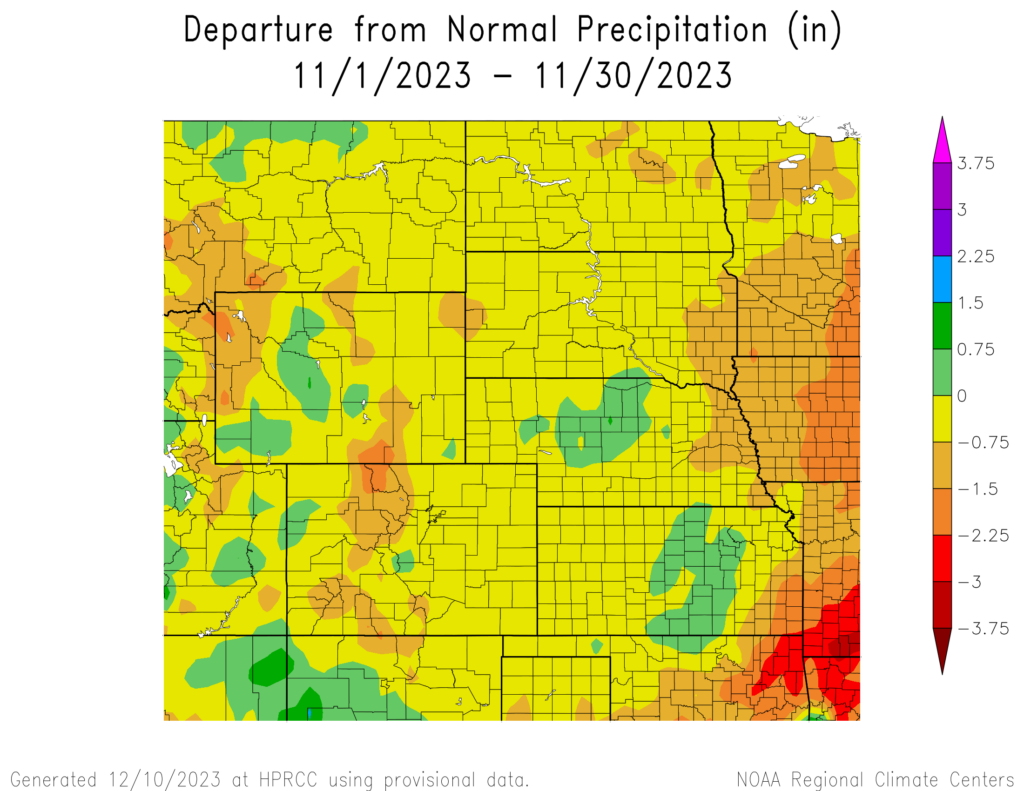
Besides the thanksgiving weekend storm, precipitation was hard to come by this month, with only isolated areas receiving above-normal amounts. Much of the region was below 25 percent of their average, with pockets of below 5 percent present. The dryness resulted in multiple places ranking in the top 5 driest, with some recording their driest November.
Bone-dry conditions have plagued much of Colorado and western Kansas this entire fall. Record wetness towards the end of spring has given way to drier conditions since then. Goodland, Kansas only received 0.66 inches (16.76 mm) of precipitation this fall to rank 4th driest. Just across the state line, no precipitation was recorded in some parts of Yuma County. Further south in Colorado, Alamosa only received trace amounts to tie for 3rd place.
Precipitation also flipped drastically in the Dakotas this month. Sioux Falls, South Dakota received 3.05 inches (7.75 cm) in September and October, only to observe 0.01 inches (0.254 mm) in November to rank 4th driest. The highest amount recorded in both states was just over one inch (2.54 cm), a far cry from nearly 7 inches (17.78 cm) for parts of South Dakota in October.
The Thanksgiving weekend storm wreaked havoc and brought large quantities of snow, particularly in Kansas. A large band of over 9 inches (22.86 cm) of snow fell from Pratt to Junction City, with 14.1 inches (35.81 cm) observed in Marion. Outside of Kansas, Wyoming experienced isolated areas of extremely heavy snowfall. The city of Lander in the west-central part of the state recorded 22.9 inches (58.17 cm) of snow that weekend, which also led the city to record its snowiest month. 18.8 inches (47.75 cm) of that fell on the 23rd which was the highest single day total since 1999. A CoCoRaHS observer outside of town observed even higher snow totals, with a whopping 27.6 inches (70.1 cm) over a two-day period.
Mountain snowpack is below normal for many of the basins in the west. Snow water equivalent (SWE) is below 50 percent in eastern Wyoming at the beginning of December. Streamflow remained well-below normal in the eastern portions of Kansas and Nebraska, with record lows reported.

Temperatures
Outside of the Thanksgiving weekend cooldown, November was the conclusion of a very warm fall for the High Plains. Nearly the entire region was warmer than normal, with some locations over 6 degrees F (3.3 degrees C) above their normal temperature for both the month and the entire fall season.
Until the 22nd, much of the lower part of the region was on track to rank in the top five warmest Novembers until a brutally cold front pushed through. Temperatures reached up to 93 degrees F (33.9 degrees C) outside of Tribune, Kansas on the 8th, which tied for the 4th warmest temperature in November for Kansas. While temperatures did cool off from these record highs, they remained well above normal. Similar to October, a late month shot of cold air shocked the region. Temperatures plummeted across the High Plains, with the thermometer bottoming out at –20 degrees F (-28.9 degrees C) in Creede, Colorado on the 27th.
Drought Conditions
The dryness this month took its toll, with a sizeable increase in drought conditions in the southern High Plains. Snowfall late in the month in eastern Kansas was too late to improve conditions in November. Overall, abnormally dry to exceptional drought (D0-D4) conditions were increased by over 6 percent.
Colorado was the driest in the region and, as a result, experienced a 21 percent increase in D0-D4. Extreme drought (D3) was also reintroduced in the state for the first time since May of this year. Conditions also continued to deteriorate in Kansas, with close to 90 percent of the state in D0-D4. Soil conditions in the state are less than ideal, especially heading into the winter months. Elsewhere in the region, other localized improvements and degradations were observed.

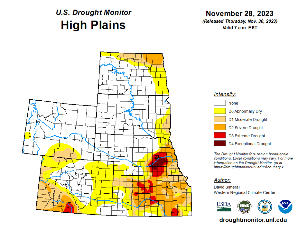
Department of Agriculture (USDA), National Drought Mitigation
Center, U.S. Department of Commerce, and the National Oceanic and
Atmospheric Administration (NOAA). For current Drought Monitor
information, please see: http://droughtmonitor.unl.edu/
Climate Outlooks
According to the Climate Prediction Center, an El Niño Advisory has been issued and is likely to be a moderate to strong event. For more information, visit https://www.cpc.ncep.noaa.gov/products/analysis_monitoring/lanina/enso_evolution-status-fcsts-web.pdf
The National Weather Service’s long-range flood outlook indicates low chances of flooding through February. According to the National Interagency Fire Center (NIFC), fire potential will be normal across the region through March.
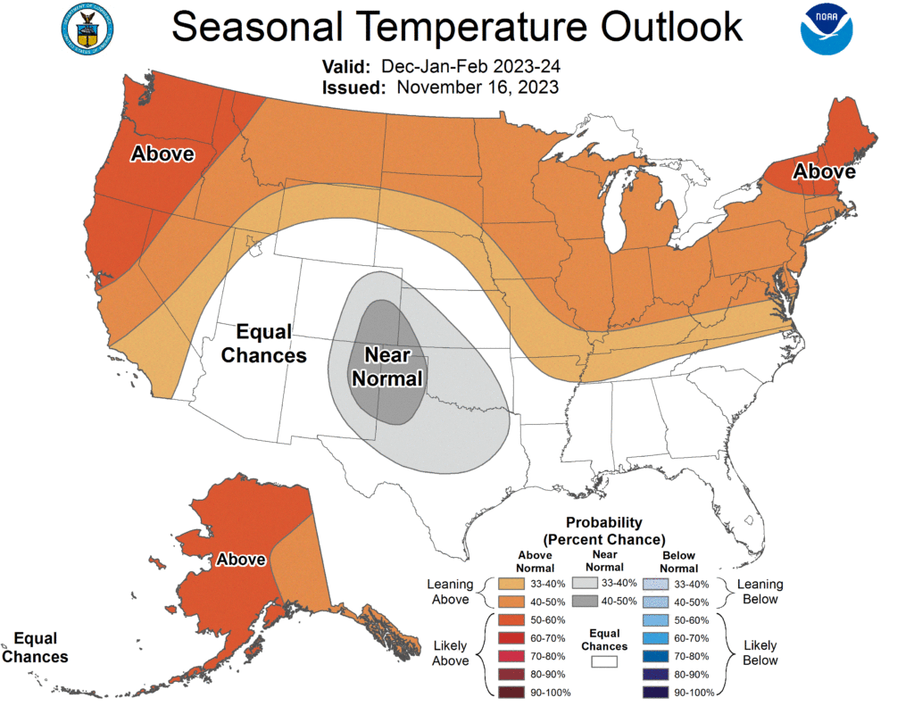
The seasonal temperature and precipitation outlook presented below combine the effects of long-term trends, soil moisture, and when applicable, the El Niño Southern Oscillation (ENSO). To learn more about these outlooks, please visit http://www.cpc.ncep.noaa.gov.
Temperature
The three-month temperature outlook shows an increased chance of above-normal temperatures across the northern United States. Increased chances of above-normal temperatures are present in the Dakotas, Nebraska, Wyoming, and eastern Kansas.
Precipitation
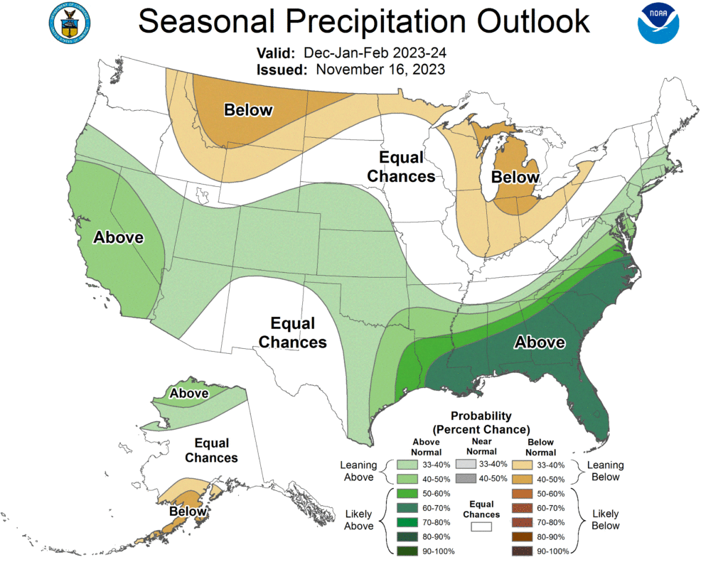
The outlook for the next three months indicates below-normal precipitation in the northern part of the country and the Great Lakes, while above-normal precipitation is favored for the southeastern United States. Increased chances of below-normal precipitation are present in parts of the Dakotas and Wyoming, while above-normal precipitation is favored for Colorado, Kansas, and Nebraska. Equal chances of above-, below-, or normal precipitation are present in the rest of the region.
Drought
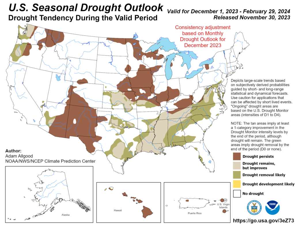
The U.S Seasonal Drought Outlook released on November 30th indicates drought conditions will likely improve in Kansas but persist for the rest of the region.
Station Summaries: By the Number


Download PDF Below
