


October 2023 Climate Summary
Glacier National Park in Montana, Photo Courtesy of Gannon Rush
Regional Breakdown
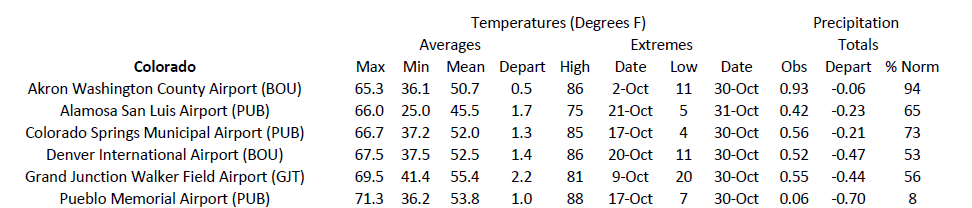
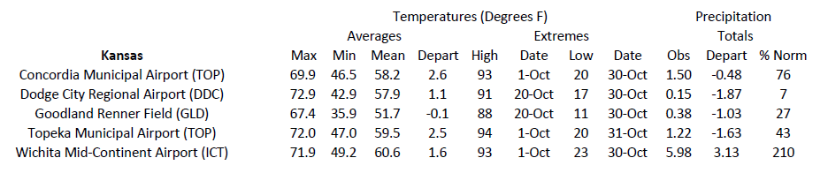
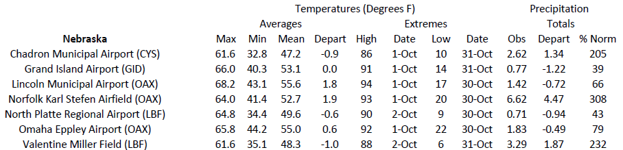
This October wrapped all seasons into a month in the High Plains. Scorching summerlike warmth and severe weather began the month, while the month ended with subzero temperatures and snow.
An unusual and impactful severe weather outbreak in Kansas and Nebraska occurred on the 3rd. Supported by temperatures reaching near or above 90 degrees F (32.2 degrees C), thunderstorms exploded across the central portions of both states. Two EF-1 tornadoes touched down causing minor damage, while winds up to 86 miles per hour (138 km/h) and 3-inch hail (7.62 cm) damaged vehicles and homes.
The first snowstorms of the year swept across parts of the region along with arctic temperatures. Several inches of snow fell in North Dakota on the 26th, limiting travel across the state. A more significant storm impacted Colorado on the 29th, with over 100 flights canceled and 700 delays at the Denver International Airport. Impacts stretched all the way into Nebraska, where two people, unfortunately, perished due to the snow and ice along Interstate 80.
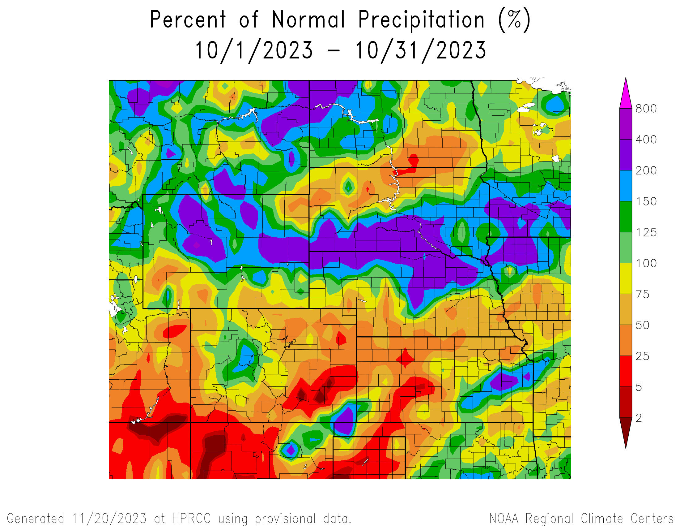
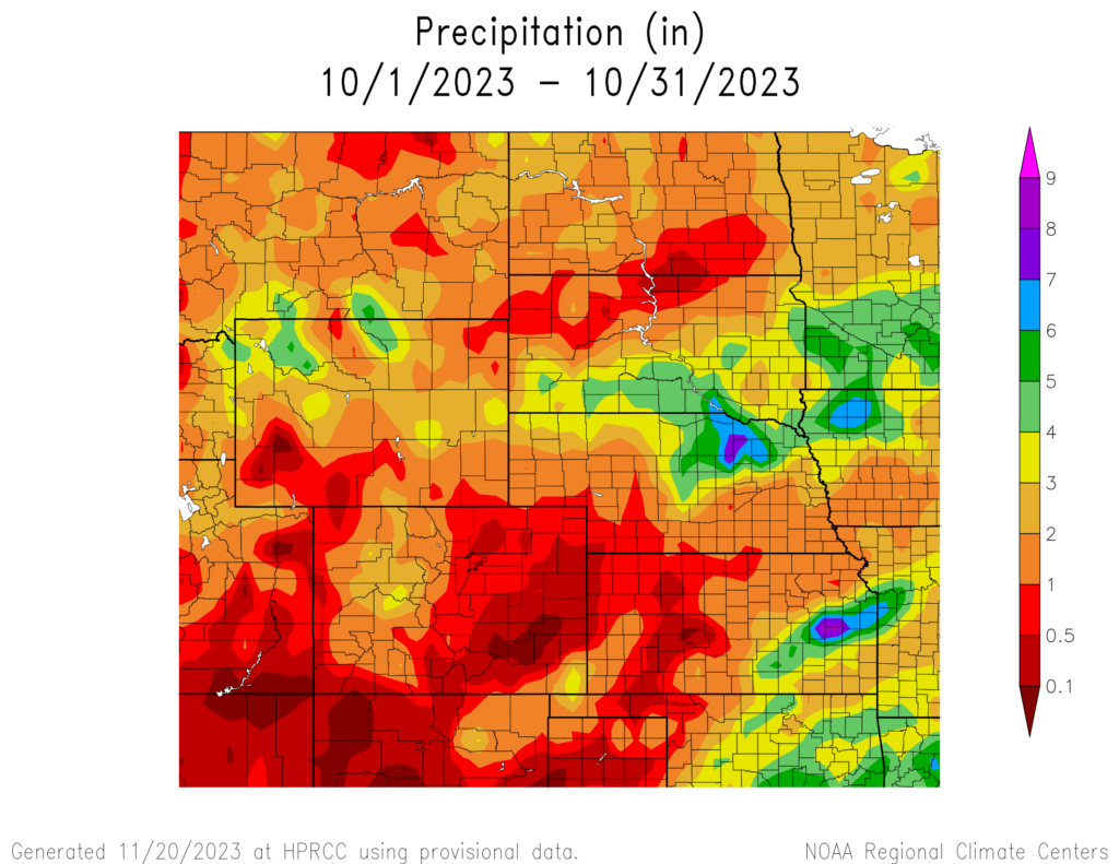
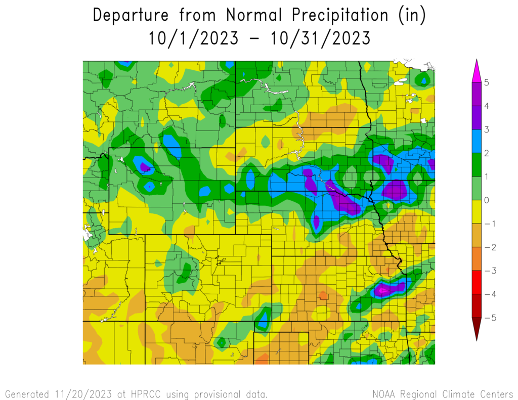
Precipitation and Water Resources
October brought precipitation to much of the northern part of the region, while the southern portions received isolated but plentiful amounts. Snow finally began falling at lower elevations, with the first winter storm of this season occurring near the end of the month.
Northern Nebraska was a big beneficiary, with several locations ranking in the top 10 wettest Octobers. Norfolk recorded 6.62 inches (16.82 cm) to rank 2nd, while to the west, Chadron observed 2.62 inches (6.66 cm) to rank 3rd. Drought conditions improved significantly across these areas as a result.
Impressive one-day precipitation amounts occurred on two separate occasions in Kansas and Nebraska. Several rounds of heavy showers on the 12th dropped 7.39 inches (18.77 cm) on an observer outside of Ewing, Nebraska, and set a record for the highest single-day precipitation total for the state of Nebraska in the month of October. Slow-moving thunderstorms on the 25th produced a staggering 9.35 inches (23.75 cm) precipitation outside of Osage City, Kansas to rank 2nd highest single-day amount in October. Several nearby observers near Emporia reported over 7.50 inches (19.05 cm) precipitation, while a large swath from Wichita to Kansas observed over 3 inches (7.62 cm).
Winter made an early appearance, with the first snowstorm impacting the northern part of the region on the 26th. Western North Dakota experienced several inches of snow, with Minot recording 11 inches (27.94 cm) and Bismarck recording 8.5 inches (21.59 cm) on the higher end. Another round of snow occurred several days later on the 29th in Colorado, with over 10 inches (25.4 cm) reported in parts of Colorado Springs and Denver.
Streamflow is in excellent shape for the majority of the region, with record highs in the northern part of the region. Eastern Kansas and Nebraska continue to grapple with drought and it was reflected in observations from the local stream gauges. Runoff for the Missouri River Basin is projected to be slightly above normal through the end of the year.
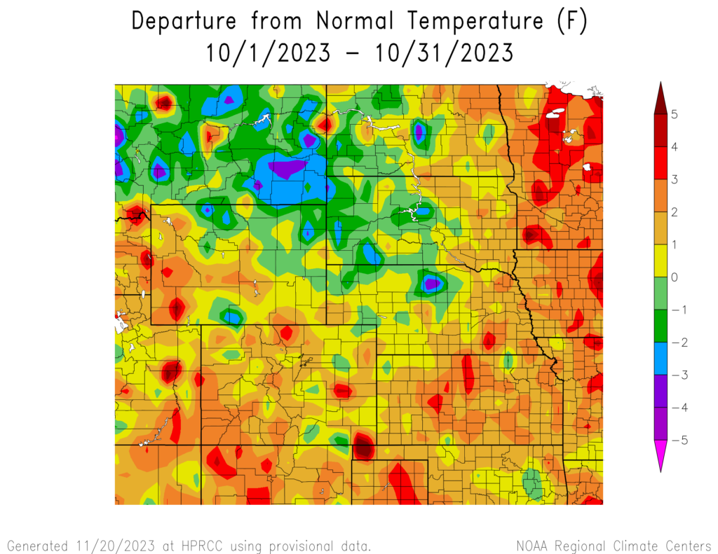
Temperatures
The overall trend of warmer temperatures continued into yet another month. A late shot of cold air provided some much-needed relief; however, parts of the region were up to 6 to 9 degrees F (3.3 to 5 degrees C) above normal in October.
The month began extremely warm, with much of the region well above 90 degrees F (32.2 degrees C). Western Kansas and southwestern Nebraska were scalding hot, reaching up to 98 degrees F (36.7 degrees C) in places. Numerous daily records were set, with some locations close to their all-time highs for October. Temperatures hovered slightly above normal until a blast of arctic air pushed through the region late in the month, leading to the first hard freeze of the year for many. Subzero temperatures were recorded in Wyoming and North Dakota, while single-digit lows reached all the way to Kansas and Nebraska. Combined with gusty winds, the region experienced a shock to an otherwise mild fall season.
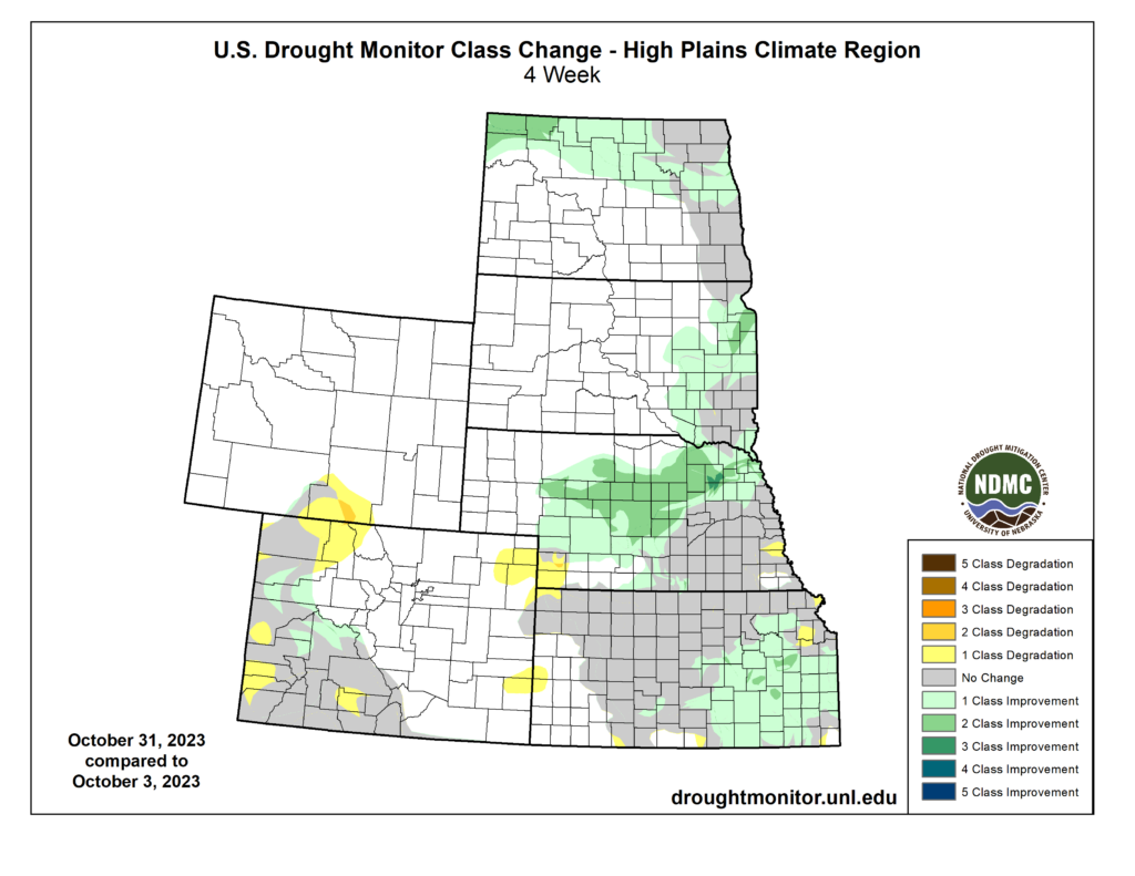
Drought Conditions
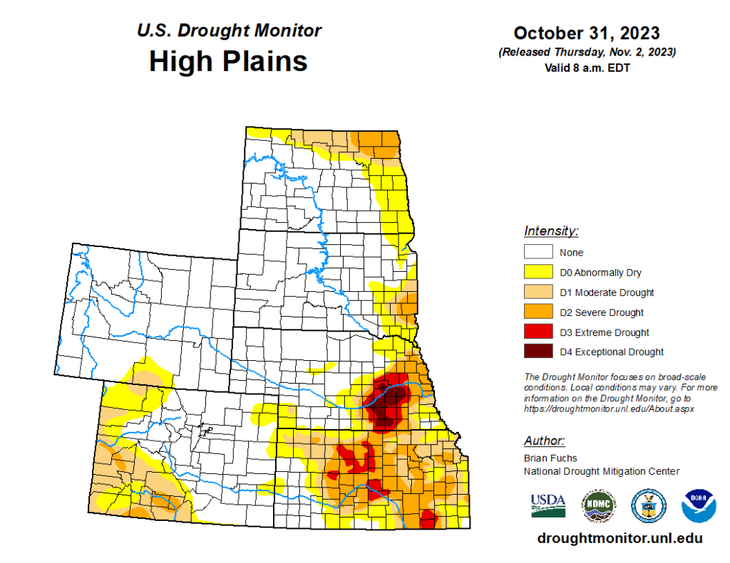
Improvements to drought conditions were the major story this month. The heavy bouts of rain led to large-scale improvements in several states. Overall, abnormally dry to exceptional drought (D0-D4) was reduced by over 5 percent in the High Plains.
Nebraska experienced the most significant changes, with up to 3 classes of improvement. Moderate to exceptional drought (D1-D4) was over 20 percent, with conditions nearly erased from the northern part of the state. Kansas also greatly benefited, with extreme drought (D3) reduced by 13 percent and D4 completely eliminated for the first time in well over a year. Parts of the Dakotas observed up to 2 classes of improvement in response to above-normal precipitation. Elsewhere in the region, other localized improvements and degradations were observed.
Department of Agriculture (USDA), National Drought Mitigation
Center, U.S. Department of Commerce, and the National Oceanic and
Atmospheric Administration (NOAA). For current Drought Monitor
information, please see: http://droughtmonitor.unl.edu/
Climate Outlooks
According to the Climate Prediction Center, an El Niño Advisory has been issued and is likely to be a moderate to strong event. For more information, visit https://www.cpc.ncep.noaa.gov/products/analysis_monitoring/lanina/enso_evolution-status-fcsts-web.pdf
The National Weather Service’s long-range flood outlook indicates low chances of flooding through January. According to the National Interagency Fire Center (NIFC), fire potential will be normal across the region through February.
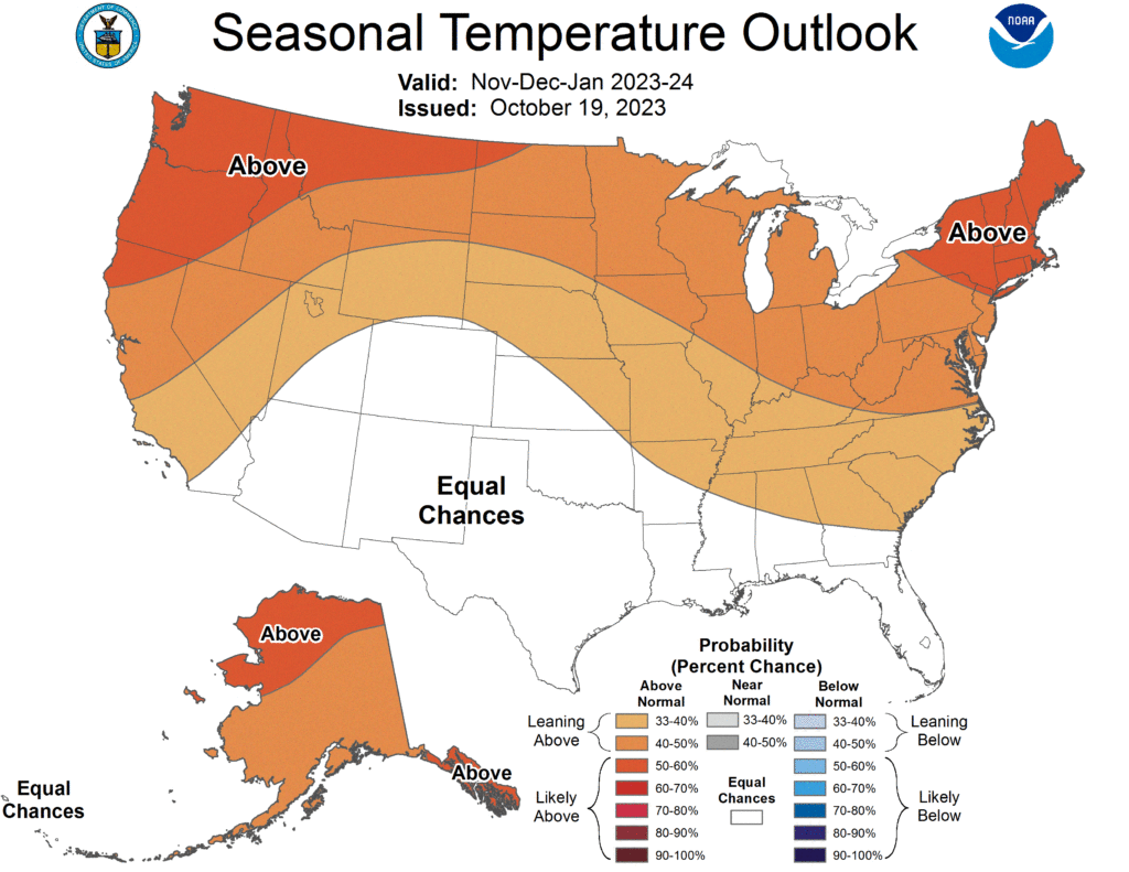
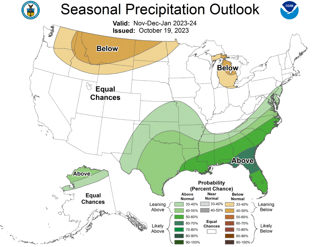
The seasonal temperature and precipitation outlook presented below combine the effects of long-term trends, soil moisture, and when applicable, the El Niño Southern Oscillation (ENSO). To learn more about these outlooks, please visit http://www.cpc.ncep.noaa.gov.
Temperature
The three-month temperature outlook shows an increased chance of above-normal temperatures across the northern United States. Increased chances of above-normal temperatures are present in the Dakotas, Nebraska, Wyoming, and eastern Kansas.
Precipitation
The outlook for the next three months indicates below-normal precipitation in the northwestern part of the country and in the Great Lakes region, while above-normal precipitation is favored for the southeastern United States. Increased chances of below-normal precipitation are present in parts of the Dakotas and Wyoming, while above-normal precipitation is favored in eastern Kansas. Equal chances of above-, below-, or normal precipitation are present in the rest of the region.
Drought
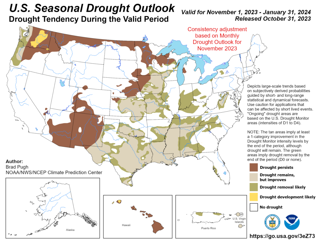
The U.S Seasonal Drought Outlook released on October 31st indicates drought conditions will likely improve in Kansas but persist for the rest of the region.
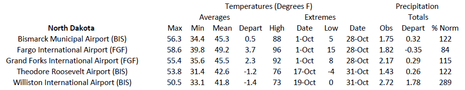
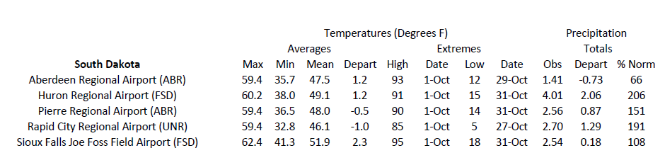
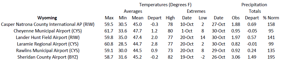
Station Summaries: By the Number
Download PDF Below