

October 2022 Climate Summary
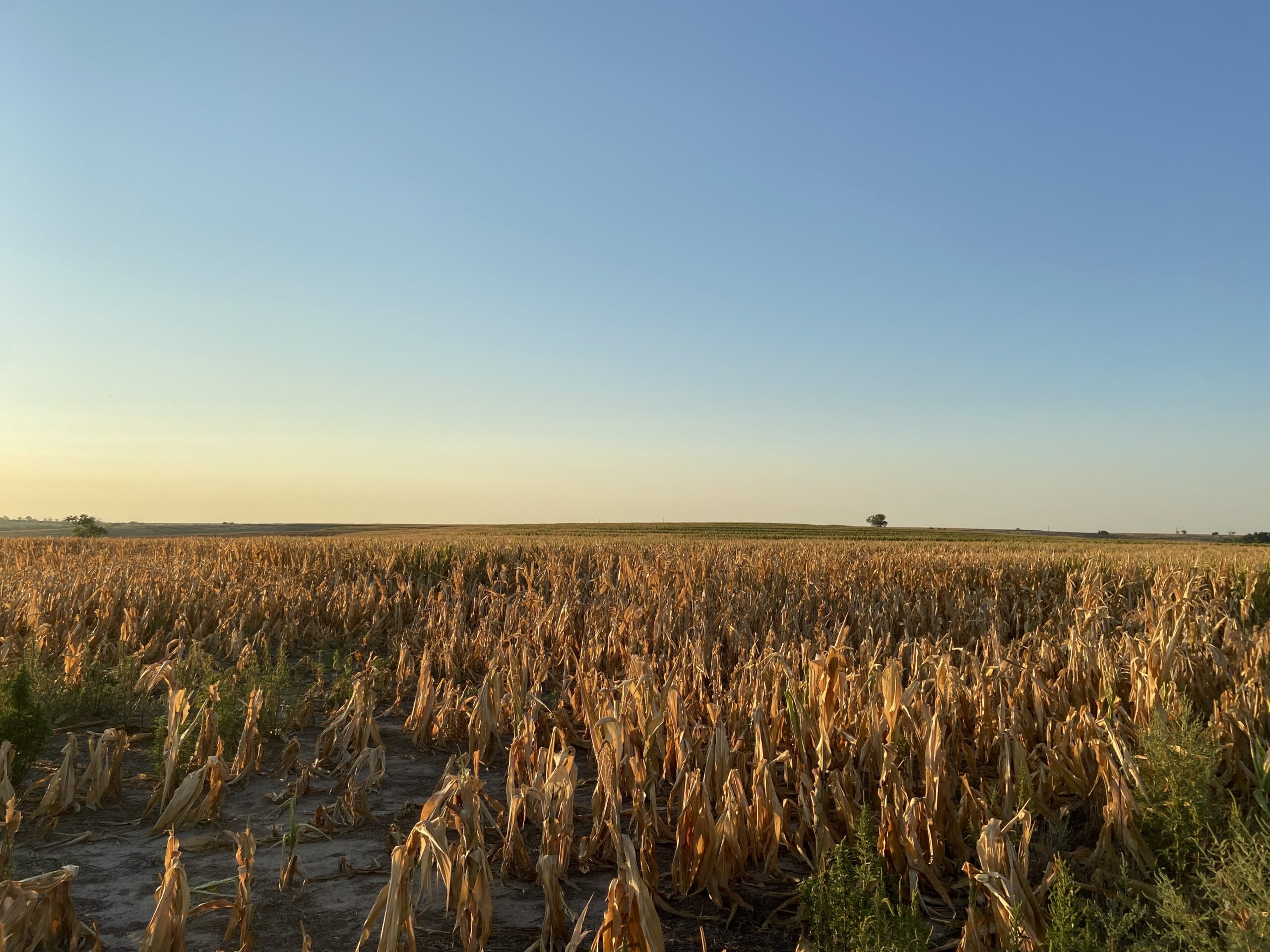
Struggling corn in Western Kansas, Photo Courtesy of Kevin Rush
Warm and Dry Start to Fall
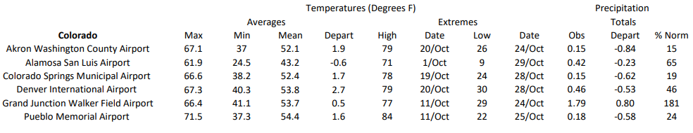
October was a month with a flavor of every season, with everything from severe storms to heavy snow across the region. Drought-stricken Kansas was nearly bone-dry, while western Colorado observed above-normal precipitation and up to 22 inches (56 cm) of snow in some places. Temperatures were above normal for much of the region throughout the month.
A vigorous low-pressure system trekked across the region on the 23rd, causing numerous impacts in multiple states. Severe storms impacted northeastern Nebraska and southeastern South Dakota, with 2-inch hail and 70 miles per hour (113 km/h) winds reported. Simultaneously, snow fell in western parts of the Dakotas and Wyoming. High winds also wreaked havoc in the southern part of the region. With ample fuel available, these winds sparked several large fires in Kansas and Nebraska. Several towns were evacuated in Nebraska due to the danger, with a large fire raging just south of Lincoln. The western parts of both states also experienced large amounts of blowing dust. The winds, unfortunately, led to two deaths in Colorado after their kayak flipped over due to the high waves.
Precipitation
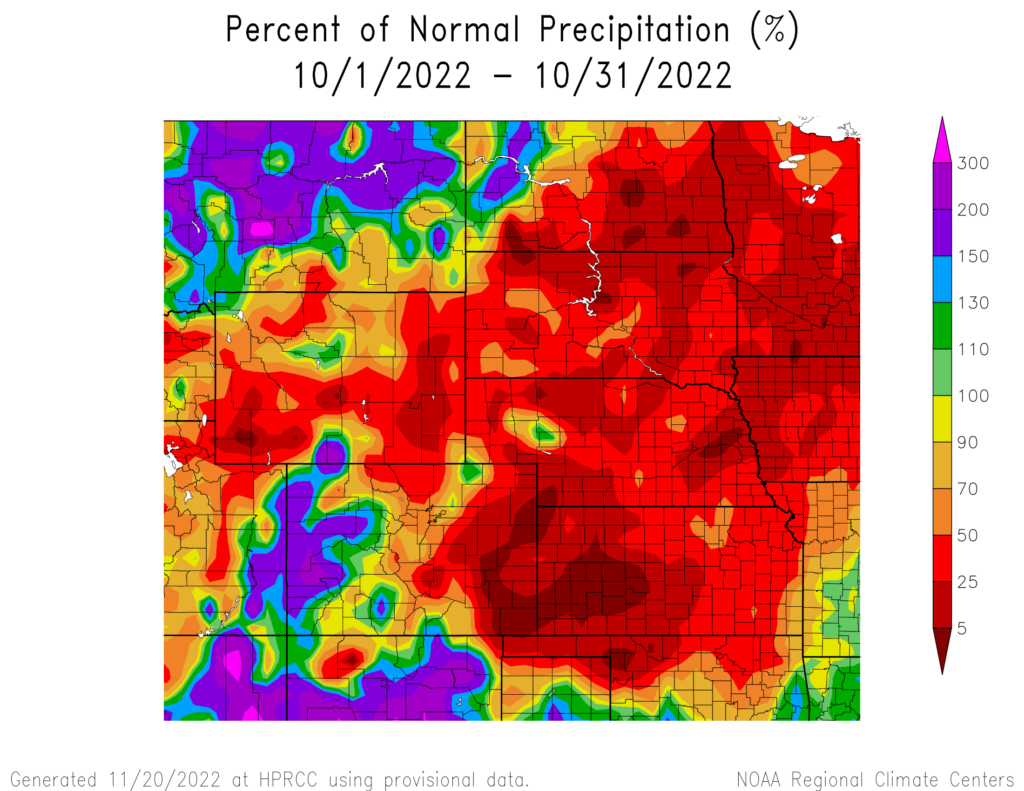
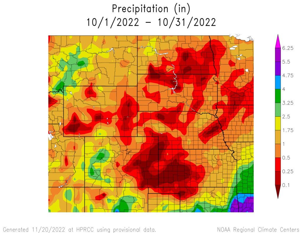
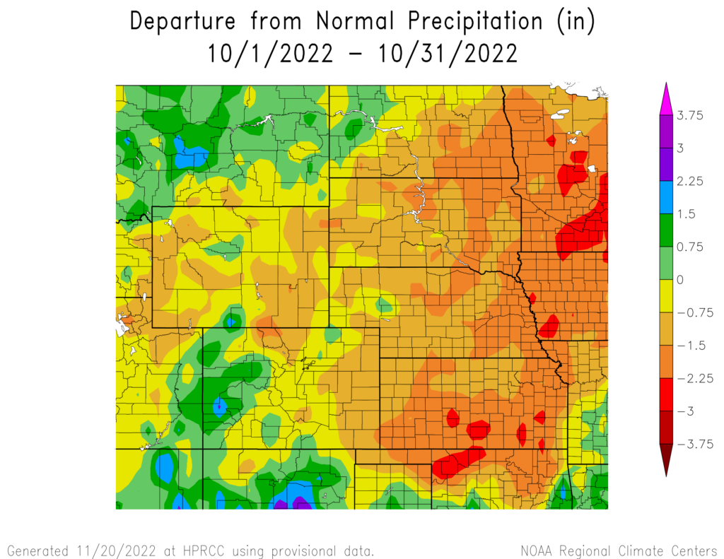
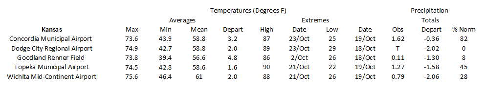
The region was extremely dry this past month, with large portions receiving less than 0.10 inches (2.54 mm) of precipitation. The western parts of Colorado and North Dakota received above-normal precipitation, however, the drought-afflicted areas in the region were bone dry.
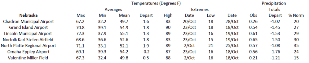
Precipitation has been very hard to come by in southwestern Kansas this year, and October did no favors. Dodge City tied their driest month on record, with only trace precipitation. Through the end of October, Dodge City is nearly 9 inches below its normal precipitation. Many locations across Kansas and Nebraska currently rank in the top 10 driest through the end of October. Norfolk, Nebraska, recorded its driest January-October, with this year being over 0.50 inches (12.70 mm) drier than in 2012.
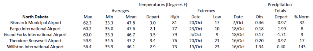
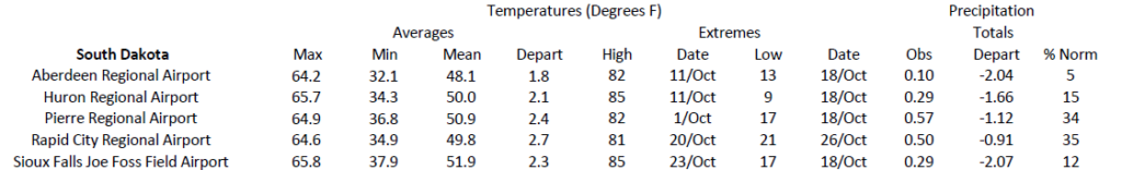
In South Dakota, Aberdeen recorded back-to-back top 10 driest months. Only 0.21 inches (5.34 mm) of precipitation has occurred, ranking 2nd driest for September-October. The lack of precipitation and warmer temperatures have led to a rapid expansion of drought conditions in that part of the state.
Streamflow Update
Streamflow across much of Kansas and Nebraska was below-normal at the
end of the month. Runoff north of Sioux City was 60% of normal at the
end of October due to the long-term effects of drought. Mountain snowpack is near normal throughout the Rockies except for southeastern Wyoming.
Temperatures
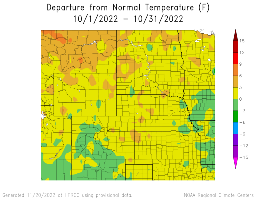
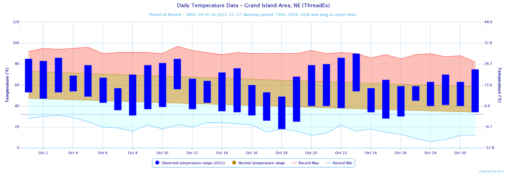
Overall, October was unusually warm throughout the region. Much of the region was above normal, with places up to 6 degrees F (3.3 C) above their normal temperature.
An unseasonably warm period impacted the region on October 21-23. Many locations set daily records, with some places reaching their warmest temperature on record through the end of the year. A total of 232 daily temperature records were broken during this period throughout the region. In Nebraska, Lincoln and Grand Island tied their warmest temperature on record for this late in the year. Another notable statistic about this heat wave is the number of 80 degrees (26.7 degrees C) plus days that Lincoln has observed this year. A whopping 142 days this year have reached that temperature, which is the most on record. Further south in Kansas, Russell reached 93 degrees F (33.9 degrees C) on the 23rd, surpassing their previous warmest temperature for the rest of the year by 4 degrees F (2.2 degrees C).
Drought Conditions
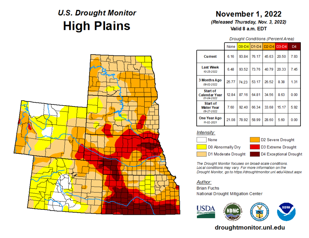
Drought conditions rapidly expanded this past month, with nearly 76 percent of the region experiencing moderate to exceptional (D1-D4) conditions. The Dakotas observed the largest increases in drought coverage, with both states increasing by over 20 percent.
As the year is nearly over, Kansas and Nebraska are in rough shape heading toward winter. In just October alone, Nebraska experienced a 21 percent increase in extreme drought (D3), and Kansas recorded nearly a 13 percent increase in exceptional drought (D4). Both states are in large precipitation deficits and will likely not see much improvement over the winter. In the meantime, not only did drought rapidly expanded in the Dakotas, but it also intensified quickly, with both states recording a 25 percent increase in severe drought (D2). Elsewhere in the region, other improvements and degradation were observed.
Department of Agriculture (USDA), National Drought Mitigation
Center, U.S. Department of Commerce, and the National Oceanic and
Atmospheric Administration (NOAA). For current Drought Monitor
information, please see: http://droughtmonitor.unl.edu/
Climate Outlooks
According to the Climate Prediction Center, La Niña conditions are likely to continue through the end of the year. A La Niña advisory is currently in effect. For more information, visit https://www.cpc.ncep.noaa.gov/products/analysis_monitoring/lanina/enso_evolution-status-fcsts-web.pdf
The National Weather Service’s long-range flood outlook indicates a low probability of Minor Flooding in eastern Kansas through January. According to the National Interagency Fire Center (NIFC), fire potential will be limited across the region through next year.
The seasonal temperature and precipitation outlook presented below combine the effects of long-term trends, soil moisture, and when applicable, the El Niño Southern Oscillation (ENSO). To learn more about these outlooks, please visit http://www.cpc.ncep.noaa.gov.
Temperature
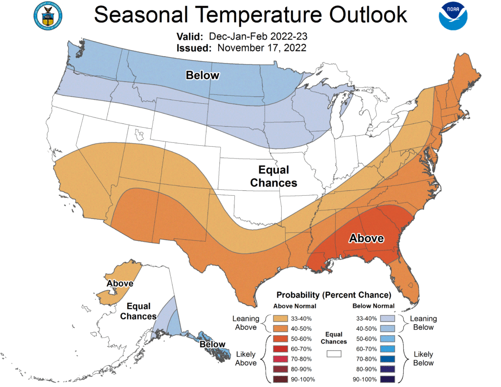
The three-month temperature outlook shows an increased chance of below-normal temperatures across the northern United States, while above-normal temperatures are favored for the southern states. Increased chances of below-normal temperatures are present in the Dakotas and the northern portions of Wyoming and Nebraska. Above-normal temperatures are slightly favored in western Colorado.
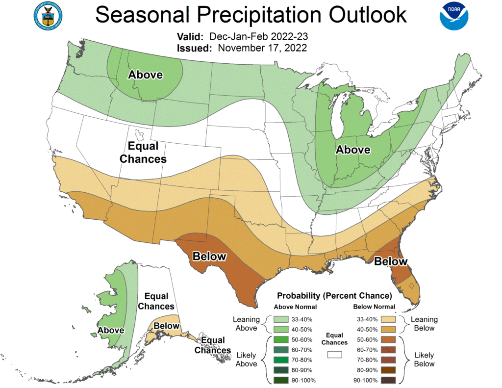
Precipitation
The outlook for the next three months indicates below-normal precipitation across the southern parts of the United States and above-normal chances across the northern portions. Above-normal precipitation is slightly favored in parts of the Dakotas and Wyoming. Drought-stricken western Kansas and southern Colorado slightly lean towards below-normal precipitation.
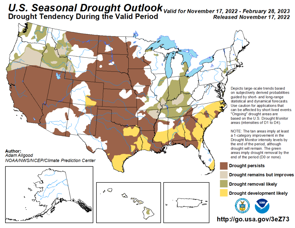
Drought
The U.S Seasonal Drought Outlook released on November 17th indicates that improvements will occur in western Wyoming, while development should occur in southern Colorado. Drought should remain entrenched throughout much of the region through winter.
Station Summaries: By the Number
Download PDF Below