


September 2022 Climate Summary
Medicine Bow National Forest in Wyoming, Photo Courtesy of Gannon Rush
Warm and Dry Start to Fall
The first month of meteorological fall was disappointing for much of the region. Instead of bringing cooler temperatures and much-needed moisture, the trend of warm and dry conditions, unfortunately, dominated the region. The dryness that had been limited to Kansas and Nebraska spread into the Dakotas. Drought conditions rapidly spread across North Dakota in response to minimal precipitation.
Among the more interesting impacts of the drought this year occurred outside of Hays, Kansas. The nearby Ellis City Lake declared a public fish salvage in response to the extremely low water levels. With levels dangerously low, the fish are in danger of using oxygen too quickly. All catch limits and size rules on fish within the lake are removed, with any means of catch acceptable. The state of Kansas fears all the fish will die, resulting in them having to completely restart the aquatic population.
The dire situation in southeastern Kansas led to serious consequences for one town. The town of Caney declared a water emergency in mid-September in response to low well levels. Water usage for outdoor purposes is banned, with the potential for citations or disconnections for residents. This part of Kansas rapidly dried out in the summer months, with September offering no relief.
produced by the High Plains Regional Climate Center and are available at: http://hprcc.unl.edu/maps/current
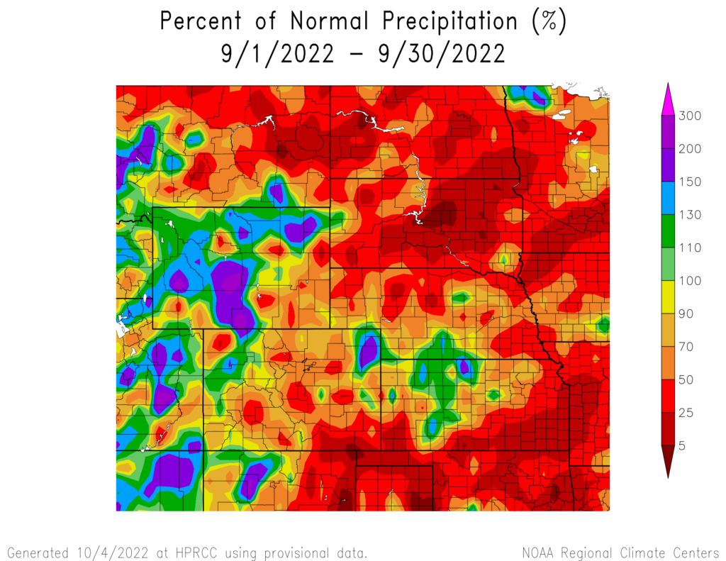
Precipitation
Much of the High Plains was dry in September, with the majority of the Dakotas receiving less than an inch of precipitation. Drought-stricken areas in the western parts of Kansas and Nebraska received some precipitation, but not nearly enough to improve drought conditions.
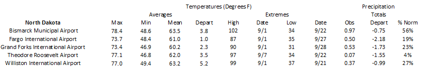
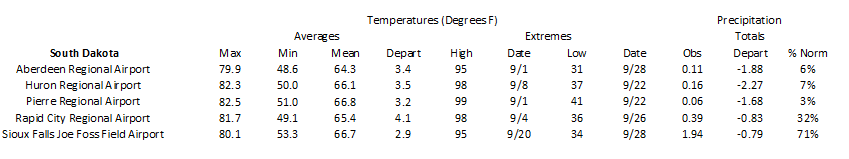
After observing near-normal to above-normal precipitation for much of this year, North Dakota was nearly bone-dry in September. Dickinson observed their driest September on record, with a paltry 0.07 inches (1.78 mm) of precipitation. In South Dakota, Sisseton fared slightly better with 0.08 inches (2.03 mm) to rank 2nd driest. Aberdeen and Pierre recorded less than 0.15 inches (3.81 mm) in September to rank in the top 10 driest.
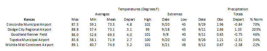
Looking further back, many locations in Kansas and Nebraska currently rank in the top 10 driest year-to-date. Arguably the driest place in the region is Garden City, Kansas. Only 5.01 inches (12.73 cm) of precipitation has fallen this year, nearly 2 inches (5.08 cm) below the previous record. In southwestern Nebraska, several locations are in the midst of their driest year-to-date. Most notably is Ogallala, which is the site of Lake McConaughy. Through the end of September, only a meager 5.74 inches (14.58 cm) of precipitation has been observed, well below the normal of 17.29 inches (43.92 cm).
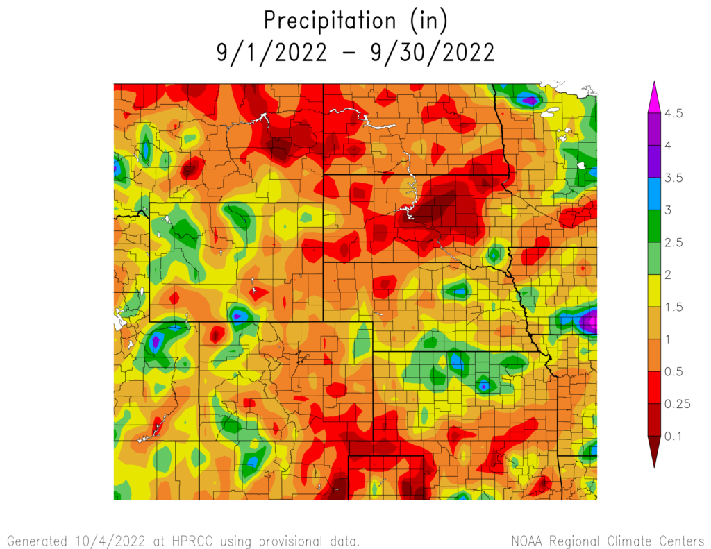
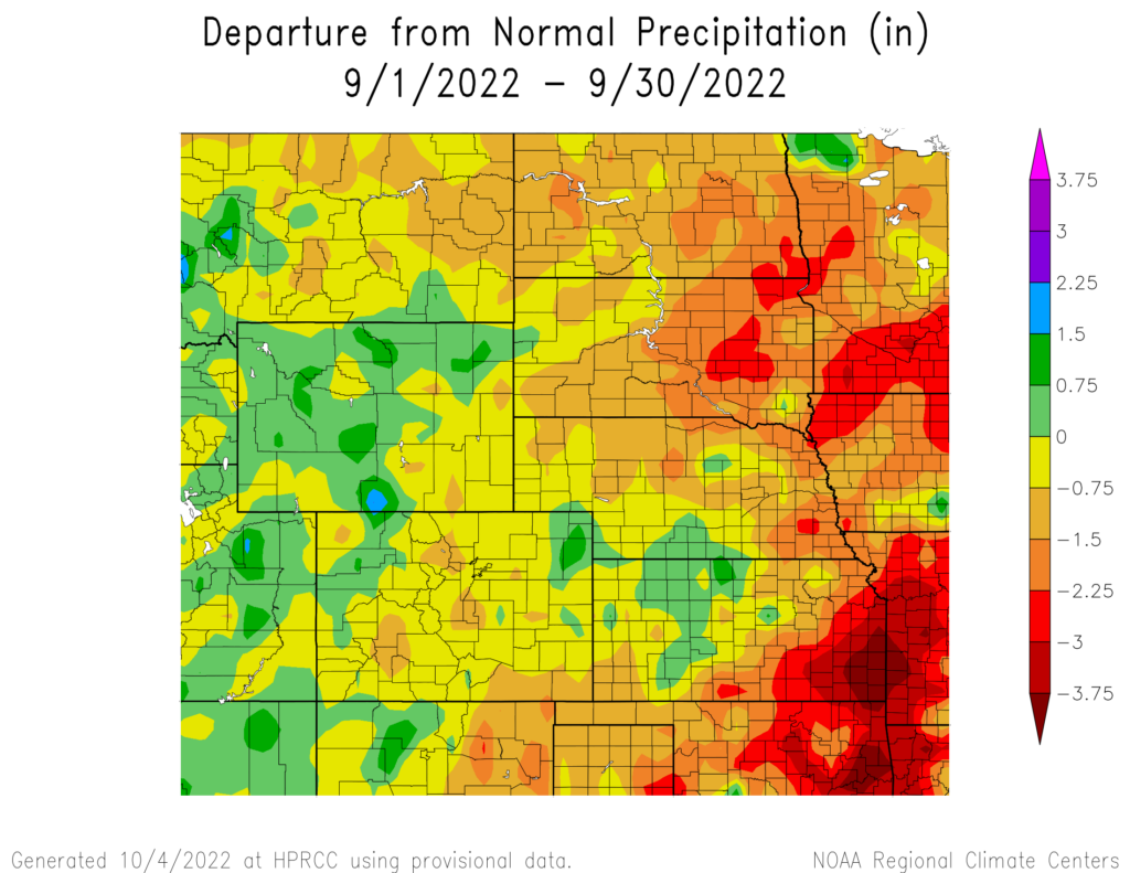
precipitation in inches (bottom) for September 2022. These maps are produced by HPRCC and can be found on the Current Climate Summary
Maps page at: http://hprcc.unl.edu/maps/current
Streamflow Update
Outside the areas impacted by drought, streamflow throughout the region was generally in good shape. Flooding continues along the James River in South Dakota resulted from heavy precipitation in previous months. Conditions in southwestern Nebraska and western Kansas continued to be much below normal. August runoff north of Sioux City was 62% of normal due to the long-term effects of drought.
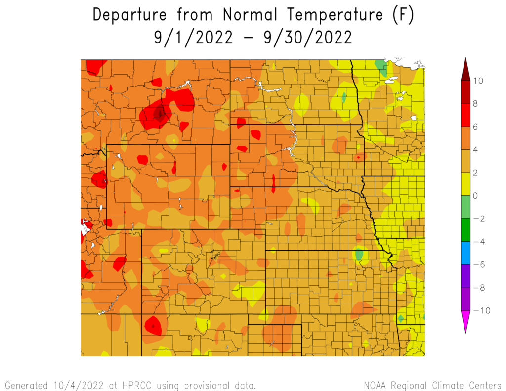
Temperatures
September temperatures were well above-normal across the region, with numerous locations ranking in the top 10 warmest months on record. Much of the region experienced 2 to 4 degrees F (1.1 to 2.2 degrees C) above normal, while small areas of 6 to 8 degrees F (3.3 to 4.4 degrees C) above normal temperatures were also present.
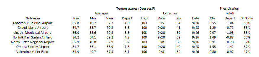
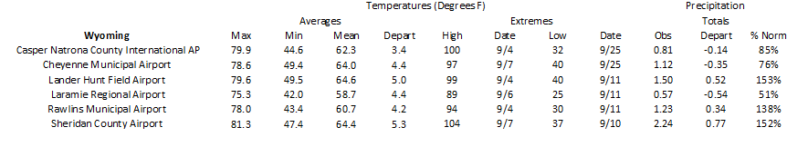
The warmest areas in the region have been eastern Wyoming and western Nebraska for the past few months. This area experienced record to near-record warmth this summer, with the trend continuing into the beginning of fall. In Wyoming, Cheyenne, Laramie, and Rawlins all ranked 2nd warmest. While in Nebraska, Scottsbluff ranked 2nd, and Chadron Station Spotlight: Chadron, Nebraska Above: Daily temperatures for September 2022, along with extremes and normals values in Chadron, Nebraska. was the warmest on record with an average temperature of 67.7 degrees F (19.8 degrees C).
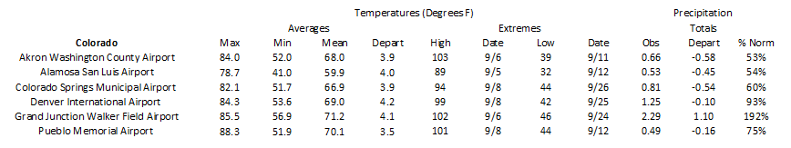
Colorado was also extremely warm this past month as well. Alamosa averaged 59.9 degrees F (15.5 degrees C) to rank warmest, while Denver ranked 3rd. Other locations such as Grand Junction, Pueblo, and Colorado Springs, also ranked in the top 5.
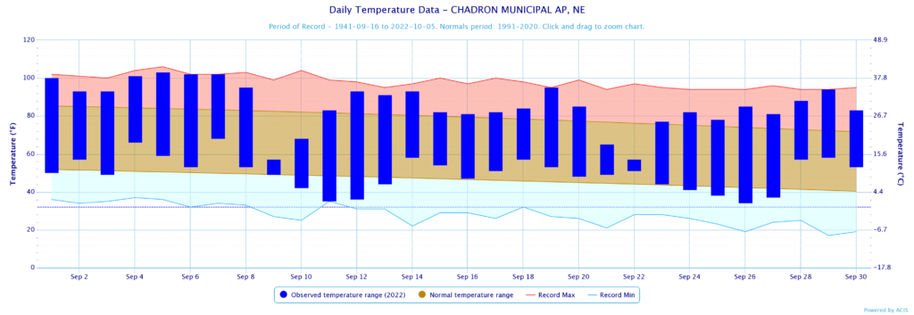
normals values in Chadron, Nebraska.
Drought Conditions
Drought not only re-appeared but rapidly spread across North Dakota after a very dry month. Outside of areas in Colorado and Wyoming, there were minimal improvements. Overall, there was a 16 percent increase in moderate to exceptional (D1-D4) this September. At the beginning of September, less than 1 percent of North Dakota was under drought conditions. By the end of the month, 72 percent of the state was experiencing drought. The lack of precipitation in the state in the past 60 days prompted the rapid expansion. Western Kansas has been the epicenter of the drought for most of the year for the state, but the southern part of the state has rapidly deteriorated in recent months. Currently, 25 percent of the state is in exceptional drought (D4). Elsewhere in the region, other improvements and degradation were observed. According to the Climate Prediction Center’s U.S. Monthly Drought Outlook for October, drought development is likely across parts of Kansas, Nebraska, and South Dakota.
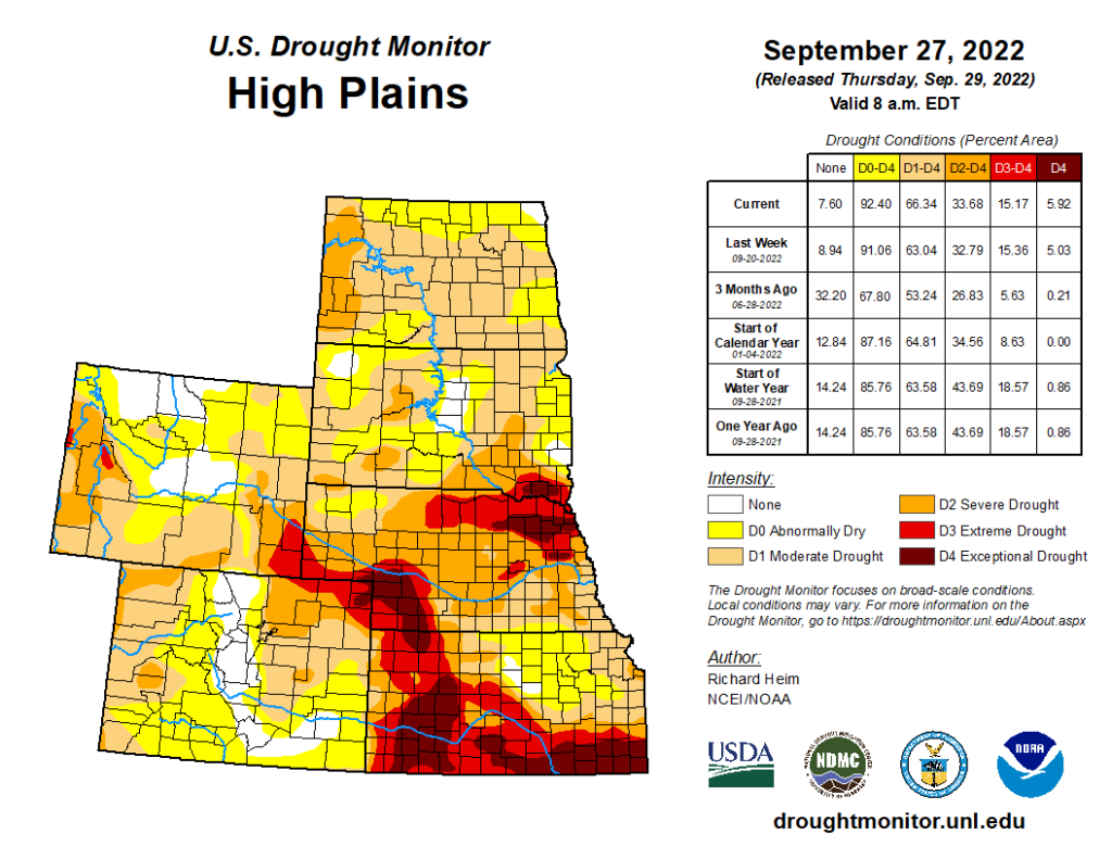
Department of Agriculture (USDA), National Drought Mitigation
Center, U.S. Department of Commerce, and the National Oceanic and
Atmospheric Administration (NOAA). For current Drought Monitor
information, please see: http://droughtmonitor.unl.edu/
Climate Outlooks
According to the Climate Prediction Center, La Niña conditions are likely to continue through the end of the year. A La Niña advisory is currently in effect. For more information, visit https://www.cpc.ncep.noaa.gov/products/analysis_monitoring/lanina/enso_evolution-status-fcsts-web.pdf
The National Weather Service’s long-range flood outlook indicates a low probability of Minor Flooding in eastern Kansas through December. According to the National Interagency Fire Center (NIFC), fire potential will be limited across the region through next year.
The seasonal temperature and precipitation outlook presented below combine the effects of long-term trends, soil moisture, and when applicable, the El Niño Southern Oscillation (ENSO). To learn more about these outlooks, please visit http://www.cpc.ncep.noaa.gov.
Temperature
The three-month temperature outlook shows an increased chance of above-normal temperatures across the majority of the United States. Equal chances of above-, below-, and near-normal are present in the Dakotas, otherwise, above-normal temperatures are favored.
Precipitation
The outlook for the next three months indicates below-normal precipitation across central parts of the United States. Across the High Plains, there are equal chances of above-, below-, and near-normal precipitation in the Dakotas and northern Wyoming. The rest of the region has increased chances of below-normal precipitation.
Drought
The U.S Seasonal Drought Outlook released on September 30th indicates drought conditions are expected to develop in Colorado, Kansas, Nebraska, and South Dakota.

Station Summaries: By the Number
Download PDF Below