August 2022 Climate Summary
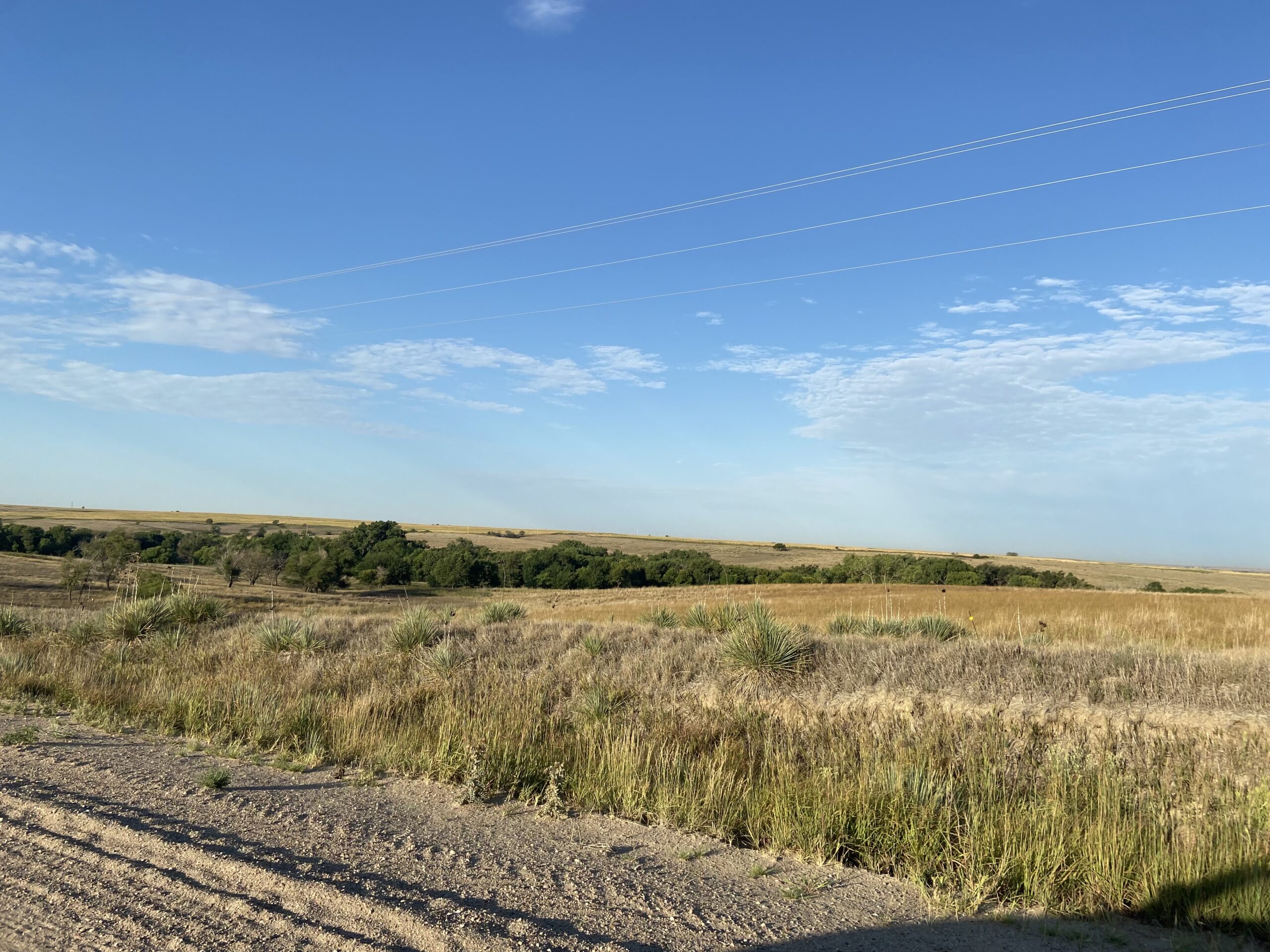
Dry Pasture in Western Kansas, Photo Courtesy of Kevin Rush
A Hot and Dry end to Summer
The summer of 2022 ended much like it began, with hot and dry conditions throughout the region. The resulting drought from these conditions and their effects has finally become clear, with numerous impacts on agriculture, livestock, and water resources. Kansas and Nebraska have taken the brunt of the drought, with conditions being as bad as 2012 in some places.
Agricultural conditions have steadily deteriorated over the summer in Kansas and Nebraska, particularly in the western parts of both states. According to the USDA National Agricultural Statistics Service, corn that was rated poor to very poor reached 50 percent in Kansas and 34 percent in Nebraska. This marked a 17 and 12 percent increase since the end of July. Fields across western Kansas are being cut for silage or filed for crop insurance as a result of the poor conditions. Even drought-resistant sorghum was impacted, with over 50 percent of fields in both states rated as poor to very poor. Nearly 78 percent of pastures in Nebraska and 65 percent in Kansas are rated poor to very poor. With such poor grasses, farmers have struggled to find feed for their cattle, and feedlots in western Kansas have been importing silage from over 50 miles away
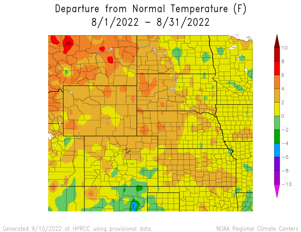
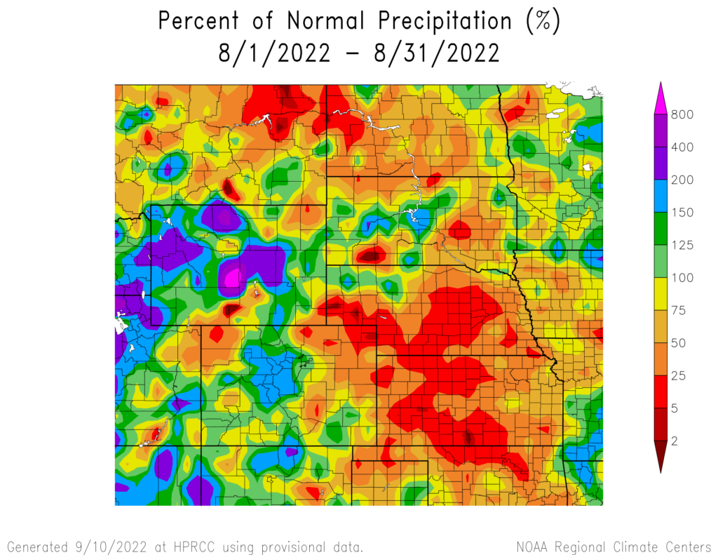
produced by the High Plains Regional Climate Center and are available at: http://hprcc.unl.edu/maps/current
Precipitation
Outside of the monsoon in the west, precipitation was spotty at best in August. The majority of Kansas and Nebraska were well below-normal this past month, further exacerbating the dire drought situation in both states.
The southwest monsoon brought beneficial precipitation to the western states, with locations such as Casper, Wyoming, and Alamosa, Colorado ranking in the top 5 wettest months on record. Sioux Falls, South Dakota, recorded their 8th wettest month with 6.88 inches (17.48 cm) of precipitation, with a large portion of this occurring during a record-breaking storm on the 7th. An incredible 5.44 inches (13.82 cm) of precipitation fell, setting a new daily precipitation record for August.
Nebraska was particularly dry, with numerous locations ranking in the top 10 driest. Omaha, Lincoln, Hastings, and Scottsbluff ranked in the top 10, with Grand Island and McCook placing 2nd driest. Not only was August dry for these locations, but also the entire summer. McCook observed their 2nd driest summer on record, with 3.37 inches (8.56 cm) of precipitation, which was slightly above the record of 3.31 inches (8.41 cm) set in 2012. Elsewhere in Nebraska, Norfolk and Scottsbluff recorded their 4th driest summers, with a dismal 1.98 inches (5.03 cm) of precipitation falling in Scottsbluff. Precipitation deficits continue to grow across the state, with areas over 10 inches below-normal since January 1st.
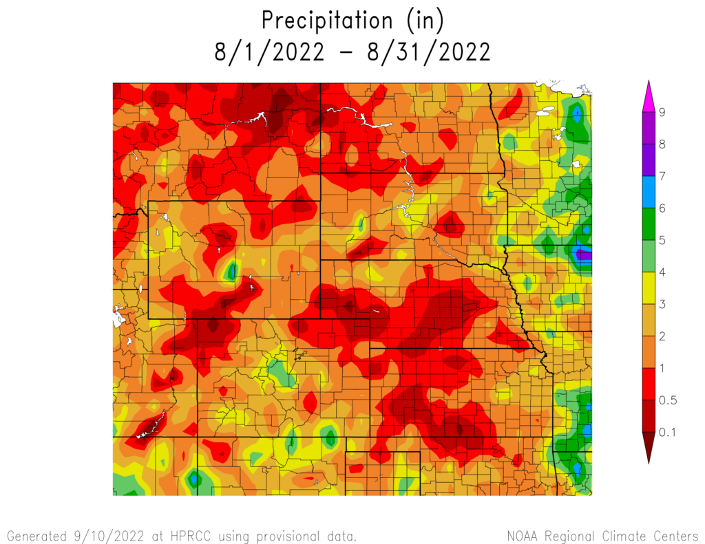
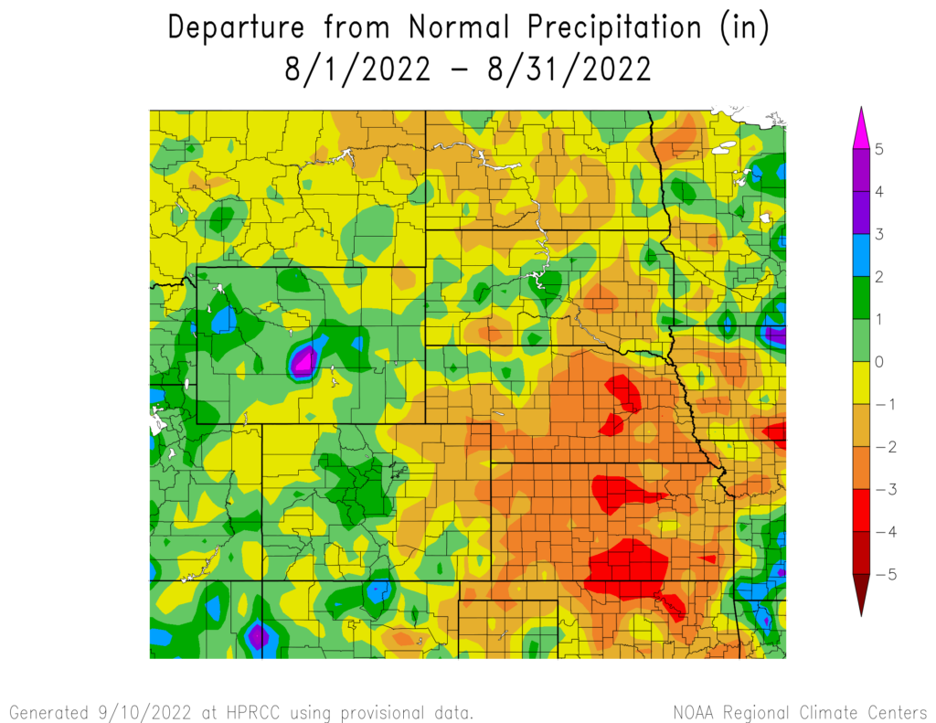
precipitation in inches (bottom) for August 2022. These maps are produced by HPRCC and can be found on the Current Climate Summary
Maps page at: http://hprcc.unl.edu/maps/current
Streamflow Update
Outside the areas impacted by drought, streamflow throughout the region was generally in good shape. Flooding continues along the James River in South Dakota resulting from heavy precipitation in previous months. Conditions in southwestern Nebraska and western Kansas continued to be much below normal. August runoff north of Sioux City was 62% of normal due to the long-term effects of drought.
Temperatures
Temperatures were above normal throughout not only August, but the entire summer. Much of the region was 2 to 4 °F (1.1 and 2.2 °C) above normal in August. Overall, most of the region was 2 to 3 °F (1.1 and 1.7 °C) above normal this summer. Numerous locations across the region ranked in the top 10 warmest Augusts and summers.
Much above-normal temperatures were present in Wyoming and western Nebraska in August. Scottsbluff, Nebraska observed its warmest month on record, with an average temperature of 77 °F (25 °C). Nearby Chadron ranked second, as did both Cheyenne and Rawlins in Wyoming. Also in Wyoming, Sheridan Station Spotlight: Scottsbluff, Nebraska Above: Daily temperatures for August 2022, along with extremes and normals values in Scottsbluff, Nebraska. and Laramie ranked 3rd warmest on record.
The same area also recorded among the warmest summers on record. Cheyenne experienced its hottest summer on record, with an average temperature of 70.6 °F (21.4 °C). Scottsbluff ranked 2nd and Laramie ranked 3rd warmest. The oppressive heat this summer was not limited to just this area, however, with several locations in Colorado and Nebraska also observing their 3rd warmest summer on record.
This past summer had some extremely warm temperatures, which is reflected in the number of heat advisories issued by the National Weather Service. Kansas led the way, with 103 advisories issued throughout the state this summer
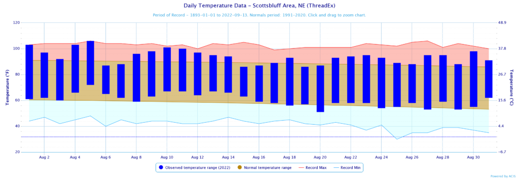
normals values in Scottsbluff, Nebraska.
Drought Conditions
The southwest monsoon brought drought relief to Colorado and parts of Wyoming, while the rest of the region continued the trend of dryness and above-normal temperatures. Overall, there was a 7 percent increase in moderate to exceptional (D1-D4) drought in August. After several months of being drought-free, D1 was re-introduced in North Dakota.
After an entire summer of near-record heat and dry weather, extreme to exceptional (D3D4) conditions have become entrenched across southwestern Nebraska and western Kansas. This has taken a significant toll on agriculture, with poor crop conditions and impacts on livestock. In the eastern parts of both states, drought conditions were introduced and slowly began to spread. On the other hand, an above-normal amount of precipitation due to the southwest monsoon improved drought conditions in Colorado with D1-D4 reduced by 33 percent compared to the beginning of the month. According to the Climate Prediction Center’s U.S. Monthly Drought Outlook for September, drought development is likely across parts of Kansas, Nebraska, and the Dakotas.

Department of Agriculture (USDA), National Drought Mitigation
Center, U.S. Department of Commerce, and the National Oceanic and
Atmospheric Administration (NOAA). For current Drought Monitor
information, please see: http://droughtmonitor.unl.edu/
Climate Outlooks
According to the Climate Prediction Center, La Niña conditions are likely to continue through the end of the year. A La Niña advisory is currently in effect. For more information, visit https://www.cpc.ncep.noaa.gov/products/analysis_monitoring/lanina/enso_evolution-status-fcsts-web.pdf
The National Weather Service’s long-range flood outlook indicates a high probability of Minor Flooding in northeastern South Dakota through November. According to the National Interagency Fire Center (NIFC), fire potential will be limited across the region through December.
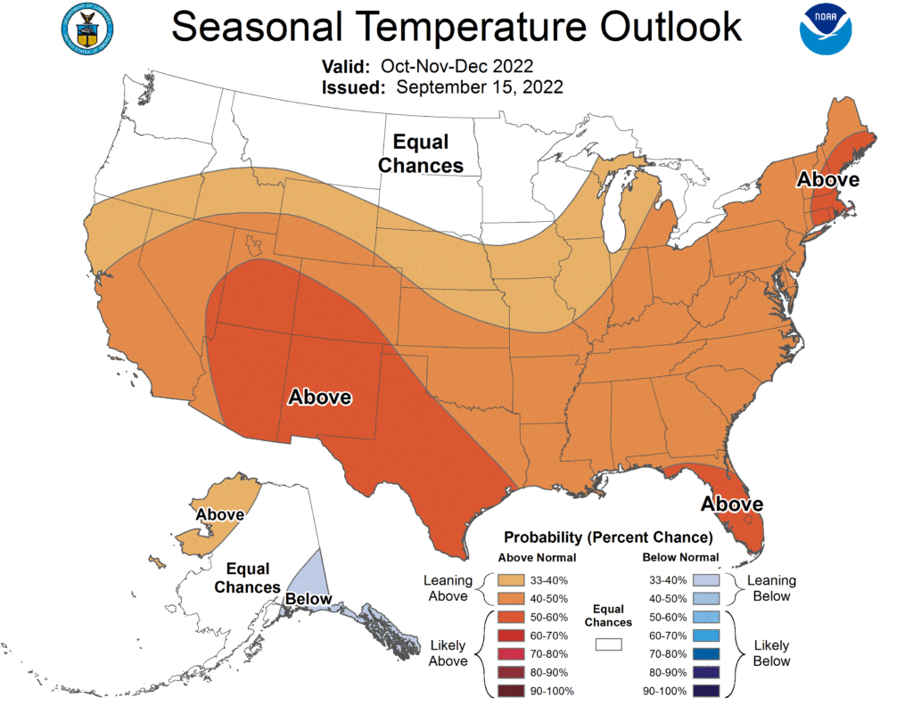
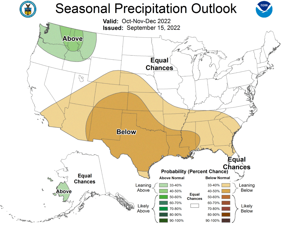
The seasonal temperature and precipitation outlook presented below combine the effects of long-term trends, soil moisture, and when applicable, the El Niño Southern Oscillation (ENSO). To learn more about these outlooks, please visit http://www.cpc.ncep.noaa.gov.
Temperature
The three-month temperature outlook shows an increased chance of above-normal temperatures across the majority of the United States. Equal chances of above-, below-, and near normal are present in the Dakotas, otherwise, above-normal temperatures are favored.
Precipitation
The outlook for the next three months indicates below-normal precipitation across central parts of the United States. Across the High Plains, there are equal chances of above-, below-, and near-normal precipitation in the Dakotas and northern Wyoming. The rest of the region has increased chances of below-normal precipitation.
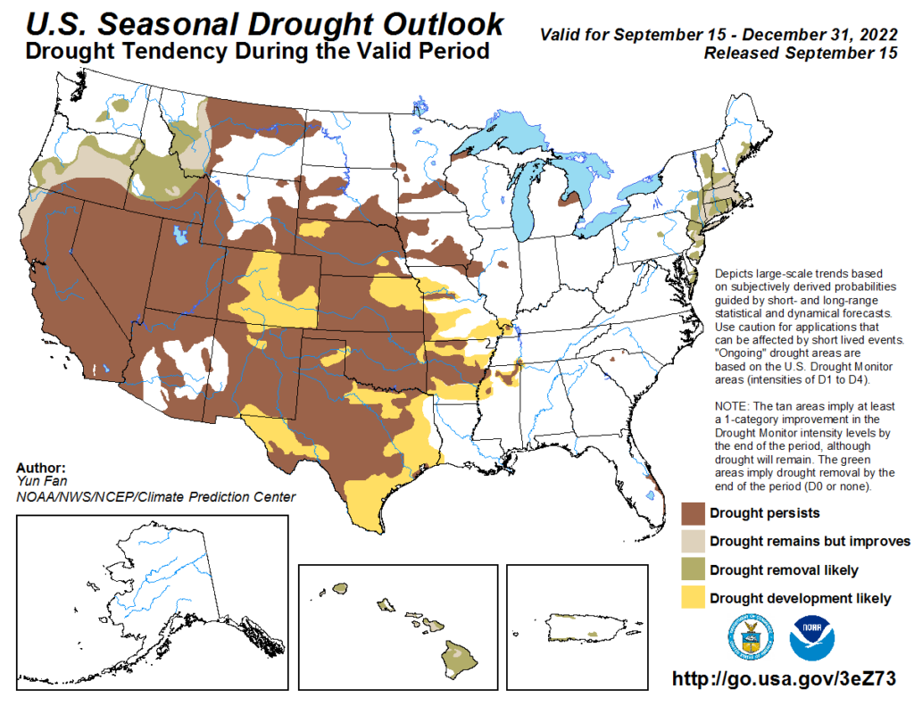
Drought
The U.S Seasonal Drought Outlook released on September 15th indicates drought conditions are expected to improve in southern Colorado and Kansas. Opposite of this, drought development is likely in parts of Nebraska, Colorado, and Kansas.
Station Summaries: By the Number


Download PDF Below
