June 2022 Climate Summary
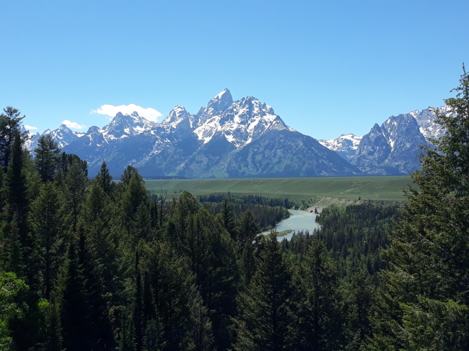
Grand Teton National Park, Photo Courtesy of Rezaul Mahmood
Warm and Dry Conditions Prevailed
Summer-like conditions took hold in the High Plains towards the middle of the month, with above-normal temperatures and below-normal precipitation across the region. Drought conditions initially were improving towards the beginning of the month due to cool temperatures and above-normal precipitation, however, the prevailing hot and dry conditions led to intensification at the end of the month.
Temperatures were extremely hot in western Kansas this month, which led to many cattle deaths. A rapid increase in temperatures from 80 degrees F (26.7 degrees C) on the 9th to 104 degrees F (40 degrees C) on the 11th led over 2,000 cattle to perish. This extreme swing combined with other factors such as high
overnight temperatures and minimal wind did not give time for cattle to adjust to conditions or to cool off.
Hailstorms were an issue for Nebraska this month, with the state having several destructive storms early in the month. Crops have been ravaged by the storms, while millions of dollars in damage has been caused to homes and vehicles. Two towns in the central part of the state have nearly 90 to 100 percent of homes significantly damaged. The most damaging storm was on the 14th when 115 mph (185 km/h) wind-driven hail of 1 to 3 inches impacted cities across the eastern portions of the state.
Heavy precipitation in northern Wyoming and the rapid melting of snowpack led to record flooding in Yellowstone National Park. Bridges and roads were washed out, while several homes were swept away by the waters. The
damage caused the park to close for over a week, with only the southern entrances reopened by the end of the month.

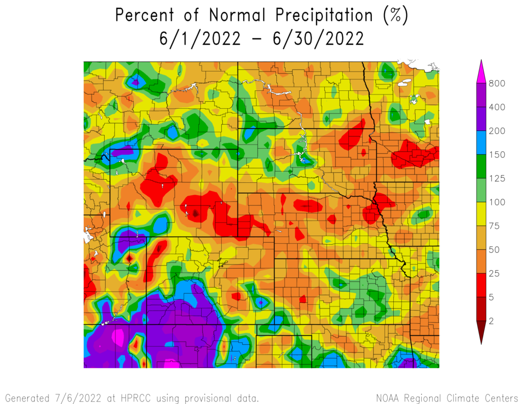
produced by the High Plains Regional Climate Center and are available at: http://hprcc.unl.edu/maps/current
Precipitation
June precipitation was well below-normal for many
parts of the region, most notably in Wyoming and western Nebraska. Contrary to this, the Southwest monsoon season began early this year, with much-needed precipitation in the southern and western parts of Colorado.
Much of Wyoming received less than an inch (25.4 mm)
of precipitation this month, with the central part of the state nearly bone dry. Lander recorded trace amounts of precipitation which ties both 1956 and 1971 for driest on record. Nearby, Casper received 0.21 inches (5.34 mm) to rank 7th driest. This dryness stretched into western Nebraska, with North Platte and Chadron ranking 2nd and 3rd driest, after 0.43 and 0.84 inches (10.92 and 21.34 mm) of precipitation, respectively.
Precipitation in South Dakota was mixed, with both the top 10 driest and wettest months recorded in the state. In the northeastern part of the state, Sisseton and Aberdeen ranked 4th and 6th driest, respectively. In the central part of the state, however, Pierre observed their 6th wettest June on
record, with 6.34 inches (16.10 cm) of precipitation.
Severe weather was near normal to slightly above average for the region in terms of warnings issued by the National Weather Service. Large hail was observed on numerous days across the region, with several days having reports of 4-inch (10.16 cm) plus diameter hail. A dangerous storm in Nebraska on the 11th dropped extremely large hailstones in the 5-inch (12.7 cm) range.
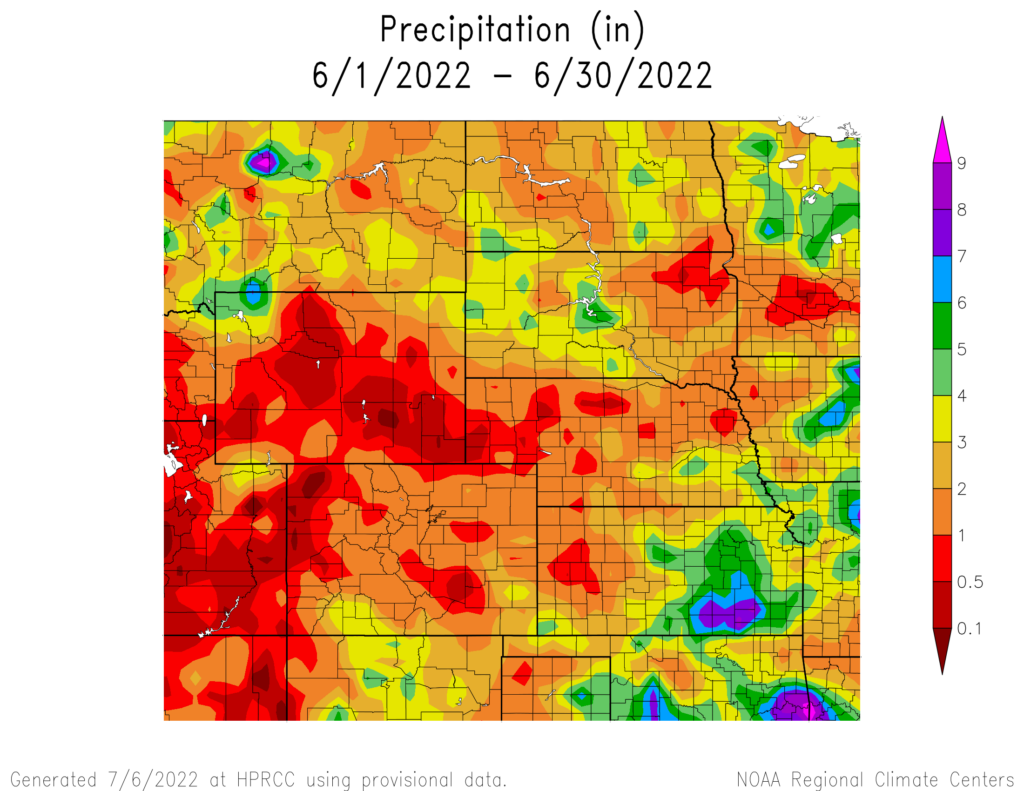
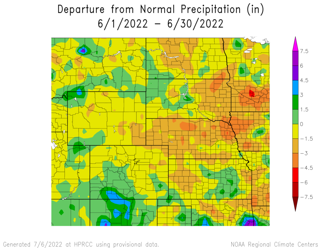
precipitation in inches (bottom) for June 2022. These maps are produced by HPRCC and can be found on the Current Climate Summary
Maps page at: http://hprcc.unl.edu/maps/current
Streamflow Update
Upper Missouri River Basin mountain snowpack completely melted in June. The U.S. Army Corps of Engineers Missouri River Water Management Division announced that they will increase the navigation flow level, with the releases from Gavins Point being adjusted. Streamflows in drought-afflicted areas such
as western Kansas and Nebraska were near record lows. However, streamflows fared much better in North Dakota and the eastern portions of South Dakota and Kansas, where precipitation has been more plentiful.
Temperatures
June was warm for much of the region, with several locations observing their top 10 warmest months on record. This was particularly noticeable during
the middle of the month when numerous temperature records were broken across the region. Towards the beginning of the month, several daily low records were broken in the western part of the region.
Temperatures were well above normal in eastern South Dakota this past month. Sisseton recorded its 3rd warmest month with temperatures averaging 73.6 degrees F (23. 1 degrees C), while Sioux Falls ranked 10th with an average temperature of 72.5 degrees F (22.5 degrees C). In western Nebraska, McCook and North Platte ranked in the top 10 with numerous warm days.
The heat wave in the middle of the month led to scorching hot temperatures. Atwood, Kansas observed a high temperature of 111 degrees F (43.9 degrees C) while McCook, Nebraska recorded a high of 109 degrees F (42.8 degrees C) on the 14th. Several locations in western Kansas observed over ten days of 100-degree F (37.8 degrees C) plus temperatures.
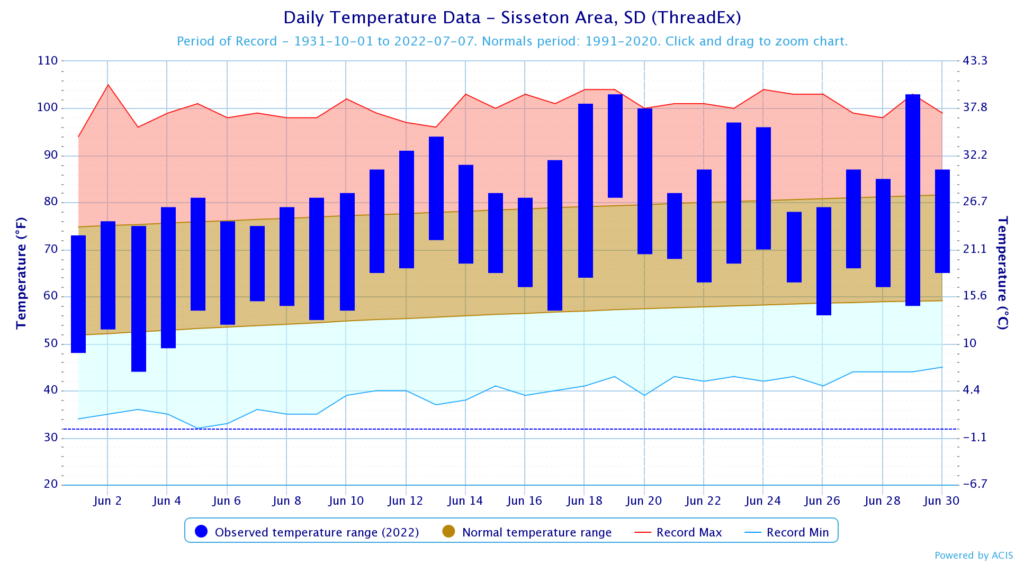
normals values in Sisseton, South Dakota.
Drought Conditions
A wet start to the month led to improvements, however, dry and windy conditions prevailed towards the end. The High Plains region observed a 6 percent decrease in moderate to exceptional (D1-D4) drought in June.
North Dakota remained drought-free the entire month.
The monsoon season began in the southwest towards
the end of the month, leading to improvements in Colorado. Severe drought (D2) was reduced by 12 percent due to this beneficial precipitation. South Dakota and Wyoming observed a 25 percent reduction to D1 after
receiving above-normal precipitation. Conditions improved slightly in southwestern Kansas, however, D4 remained entrenched in the area. A large swath of extreme drought (D3) was introduced at the end of the month along the Colorado and Nebraska border. Elsewhere in the region, other improvements and degradation were observed. According to the Climate Prediction Center’s U.S. Monthly Drought Outlook for July, drought conditions are likely to develop in parts of Colorado, Kansas, Nebraska, and South Dakota.

Department of Agriculture (USDA), National Drought Mitigation
Center, U.S. Department of Commerce, and the National Oceanic and
Atmospheric Administration (NOAA). For current Drought Monitor
information, please see: http://droughtmonitor.unl.edu/
Climate Outlooks
According to the Climate Prediction Center, La Niña conditions are likely to continue through the end of the year. A La Niña advisory is currently in effect. For more information, visit https://www.cpc.ncep.noaa.gov/products/analysis_ monitoring/lanina/enso_evolution-status-fcsts-web.pdf
The National Weather Service’s long-range flood outlook through July indicates a high chance of Major Flooding in northeastern South Dakota through August. According to the National Interagency Fire Center (NIFC), fire potential will be limited through October.
The seasonal temperature and precipitation outlooks presented below combine the effects of long-term trends,
soil moisture, and when applicable, the El Niño Southern Oscillation cycle (ENSO). To learn more about these
outlooks, please visit http://www.cpc.ncep.noaa.gov.
Temperature
The three-month temperature outlook shows an increased chance of above-normal temperatures across the majority of the United States. The entire High Plains region has increased chances of above-normal temperatures, with Colorado notably favored.

Precipitation
The outlook for the next three months indicates below-normal precipitation across central parts of the United States. Across the High Plains there are equal chances of above-, below-, and near-normal precipitation in Colorado and Wyoming. The rest of the region has increased chances of below-normal precipitation.

Drought
The U.S Seasonal Drought Outlook released on June 30th indicates drought conditions are expected to remain with development likely in parts of Colorado, Kansas, Nebraska, and South Dakota.

Station Summaries: By the Number


Download PDF Below
