April 2022 Climate Summary
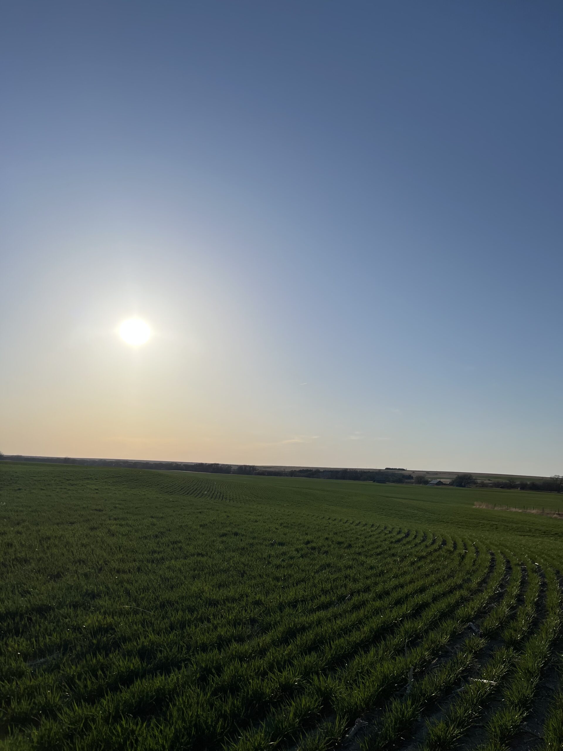
Kansas Winter Wheat Field, Photo Courtesy of Gannon Rush
Drought in the Southern Plains and Blizzards in the North
April was the ‘tale of two cities’ in the High Plains. Grand Forks, North Dakota was among the wettest and coldest on record, while Colorado Springs, Colorado was among the warmest and driest on record. The northern states experienced well below normal temperatures and multiple blizzards, while the southern states remained dry and dealt with wildfires.
Several blizzards tracked through North Dakota during the month, including the historic blizzard from April 12th to 14th. The heavy snowfall combined with gusts up to 60 mph (96.56 km/h) led to drifts up to 8 feet tall. Among the highest snowfall amounts was a report of 36.0 inches (91.44 cm) outside of Minot. The highest verified amount was 29.5 inches (74.93 cm) outside Dunn Center. With such high winds, it is hard to accurately measure snowfall. Another blizzard struck the same areas late in the month, with snowfall up to 18.0 inches (45.72 cm).
Wildfires were an issue in the southern portion of the region, particularly in Nebraska. Two large fires broke out during the month, which led to two deaths and several towns to be evacuated. The first fire broke out near Arapahoe, with nearly 35,000 acres burned over several days. Later in the month, another fire broke out nearby which burned over 44,000 acres. Several other fires occurred in Colorado during the month, particularly in areas that were extremely dry this month.
Another interesting impact of the ongoing drought was the reduction of hunting permits available for pronghorn and mule deer in Wyoming. Due to the dryness, food sources of these animals are impacted. As a result, permits were reduced to conserve populations this year. Animal populations were already low from the previous year, with the mule deer population only 61 percent of the statewide goal.
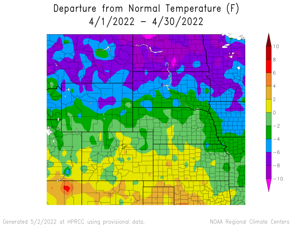

produced by the High Plains Regional Climate Center and are available at: http://hprcc.unl.edu/maps/current .
Precipitation
Precipitation for the High Plains in March was sharply divided. The northern part of the region was above to well above-normal, while the southern parts were below-normal. Several locations in North Dakota were among the wettest on record, in contrast to multiple places in the southern portions ranking among the driest. The above-normal precipitation in North Dakota helped improve drought conditions, while the dryness in the south only exacerbated drought conditions.
Several blizzards in North Dakota led both Fargo and Grand Forks to rank as their second wettest April on record. Both locations observed over 5 inches (12.70 cm) of precipitation for the month. Bismarck recorded their snowiest April on record with 21.9 inches (55.63 cm) of snow falling while also ranking 10th wettest. Along the front range of the Rockies, conditions were dry. In Colorado, Akron and Colorado Springs both observed their driest month on record with minimal precipitation falling. Several locations with eastern Wyoming, western Kansas, and western Nebraska also ranked among the driest Aprils on record.
It was an active month for severe weather across the region, with multiple days of severe weather. Most notably on the 29th, several storms impacted Kansas and Nebraska. Both Kansas and Nebraska reported 4-inch (10.16 cm) hailstones, while an impressive 91 mph (146.45 km/h) wind gust was recorded outside Davenport, Nebraska. On the same day, a high end EF-3 tornado tracked through Andover, Kansas causing significant damage and leading to 3 injuries.


precipitation in inches (bottom) for April 2022. These maps are produced by HPRCC and can be found on the Current Climate Summary
Maps page at: http://hprcc.unl.edu/maps/current.
Snowpack Update
Snowpack at the end of April was above normal for the Upper Missouri River Basin mountains. According to the U.S. Army Corps of Engineers, as of April 24, Snow Water Equivalent (SWE) above Fort Peck Reservoir is currently at 14.2 inches (36.07 cm) which is 92% of the average (1981-2010). The reach between Fort Peck and Garrison Reservoirs is currently 13.3 inches (33.78 cm) which is 95% of the average (1981-2010). SWE was near or above median in most Wyoming basins. In Colorado, SWE was well below normal in the southwestern basins.
Temperatures
Cooler temperatures were present throughout much of the region this month, with well below normal temperatures in the northern states. Multiple locations in the north ranked among the coldest months on record.
In addition to the heavy snowfall across North Dakota, temperatures were also well below normal for the state. Grand Forks ranked 2nd coldest month on record, with an average temperature of 31.8 degrees F (-0.1 degrees C) which is below freezing. Dickinson, North Dakota, and Sisseton, South Dakota also both recorded their 3rd coldest April on record. A number of locations in North Dakota, South Dakota, and
Wyoming observed a top 10 coldest months on record.
Opposite of the cooler temperatures to the north, the southern part of the region experienced above-normal temperatures. Temperatures skyrocketed on the 22nd and 23rd, with areas in Colorado, Kansas, and Nebraska exceeding 90 degrees F (32.2 degrees C). The highest
temperature of 101 degrees F (38.3 degrees C) was recorded southwest of North Platte, Nebraska on April 23rd. High winds were once again present during these two days, which led to fire issues. The Strom Prediction Center issued several extremely critical fire days during the month during these hot and windy periods

normals values in Grand Forks, North Dakota.
Drought Conditions
Dryness continues in the southern parts of the region, while the northern parts received normal to above-normal precipitation. Drought conditions improved significantly in North Dakota and parts of South Dakota after the recent snowstorms, while Kansas and Nebraska remained dry.
The dryness across the western parts of both Nebraska and Kansas led to widespread expansion of extreme drought (D3). Nearly 20 percent of both states are in D3 at the end of April. Some precipitation fell in the drought-stricken areas towards the end of the month, which should improve conditions. Severe drought (D2) also greatly expanded across eastern Colorado towards the end of the month, with many areas receiving well below 25 percent of their normal precipitation. Contrary to the dryness, the northern parts of the region have observed above-normal precipitation. Drought conditions improved one to two classes across the western Dakotas and northern Wyoming. Elsewhere in the region, other improvements and degradation were
observed. According to the Climate Prediction Center’s U.S. Monthly Drought Outlook for May, improvements in drought conditions are likely across South Dakota, Nebraska, Kansas, and northeastern Wyoming.

Department of Agriculture (USDA), National Drought Mitigation
Center, U.S. Department of Commerce, and the National Oceanic and
Atmospheric Administration (NOAA). For current Drought Monitor
information, please see: http://droughtmonitor.unl.edu/
Climate Outlooks
According to the Climate Prediction Center, La Niña conditions are likely to continue into the summer. A La Niña advisory is currently in effect. For more information,
visit https://www.cpc.ncep.noaa.gov/products/analysis_
monitoring/lanina/enso_evolution-status-fcsts-web.pdf
The National Weather Service’s long-range flood outlook through July indicates a high chance of minor flooding across eastern South Dakota and the lower basin in May. This will decrease over the next three months. There is a high risk of Major Flooding in northeastern South Dakota and central North Dakota. According to the National Interagency Fire Center (NIFC), fire potential will be limited
in May and June but expand across the entire region by July.
The seasonal temperature and precipitation outlooks presented below combine the effects of long-term trends, soil moisture, and when applicable, the El Niño Southern Oscillation cycle (ENSO). To learn more about these outlooks, please visit http://www.cpc.ncep.noaa.gov.
Temperature
The three-month temperature outlook shows an increased chance of above-normal temperatures across the majority of the United States. In the High Plains, North Dakota and northeastern South Dakota have equal chances of above-, below-, and near-normal temperatures. Meanwhile, the rest of the region has increased chances of above-normal temperatures with Colorado heavily favored.

Precipitation
The outlook for the next three months indicates below-normal precipitation across the majority of the western United States. Across the High Plains there are equal chances of above-, below-, and near-normal precipitation in North Dakota and northern South Dakota. The rest of the region has increased chances of below-normal precipitation.

Drought
The U.S Seasonal Drought Outlook released on April 30th indicates drought conditions are expected to remain but conditions improve across the Dakotas, Nebraska, and Kansas. Conditions are expected
to persist across Colorado and Wyoming with development likely in the central parts of the states.

three-month precipitation probability outlook (middle), and the U.S.
Seasonal Drought Outlook (bottom). For more information on these
outlooks, produced by the Climate Prediction Center, see:
http://www.cpc.ncep.noaa.gov.
Station Summaries: By the Number


Download PDF below
