March 2022 Climate Summary
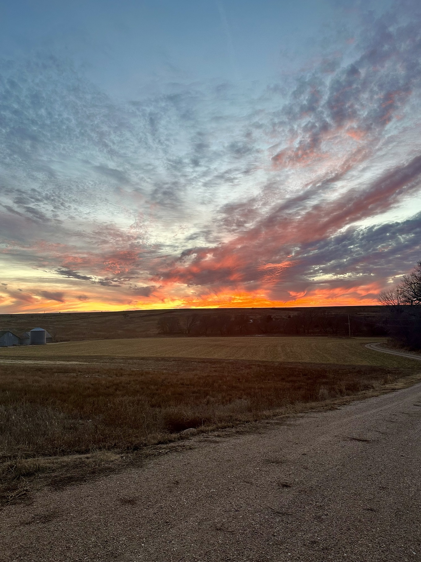
Foothills of Colorado, Photo Courtesy of Gannon Rush
Dryness Continued into March
The dryness that has gripped parts of the region over the winter continued into March. This led to the intensification and growth of drought across South Dakota, Nebraska, and western Kansas. All three states ended the month with 45 percent of the state in severe drought (D2). In preparation for the continuation of the drought, cattle herds are being culled in Nebraska. Feedlots in the state are now near-record numbers, which is unusual for this time of the year.
Repercussions from the drought of 2021 are becoming noticeable in North Dakota. Many cattle producers within the state rely on water from surface water sources such as stock ponds. These water sources were dried up or contained substances toxic to livestock during the drought of previous years. As a result of the lack of snowpack this winter for recharge or the dilution of toxic substances, there are concerns about the availability of water this year. Ranchers within the state have been encouraged to find other sources of water to reduce the potential for issues this year.
Another side effect of the dryness across the region is the increased risk of wildfires. Optimal conditions for wildfires across western Kansas throughout the month led the governor to declare a state of disaster. Several large fires broke out in the southern part of the state, with the largest reported to the northwest of Wichita. Fires were also reported in Colorado, Nebraska, and South Dakota in the month of March.
Opposite of the dryness, eastern North Dakota has been extremely wet. There are concerns about flooding along the Red River after numerous snowstorms this winter. Flooding in this region would lead to delays in planting, which could impact wheat output this year.
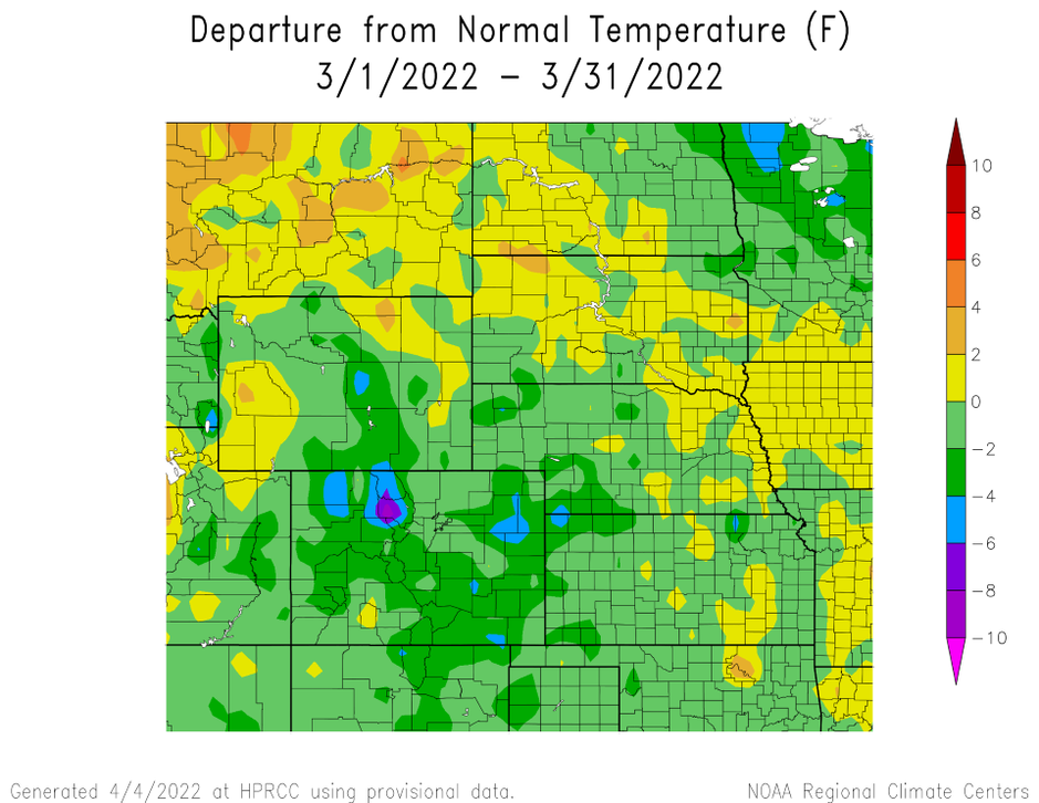
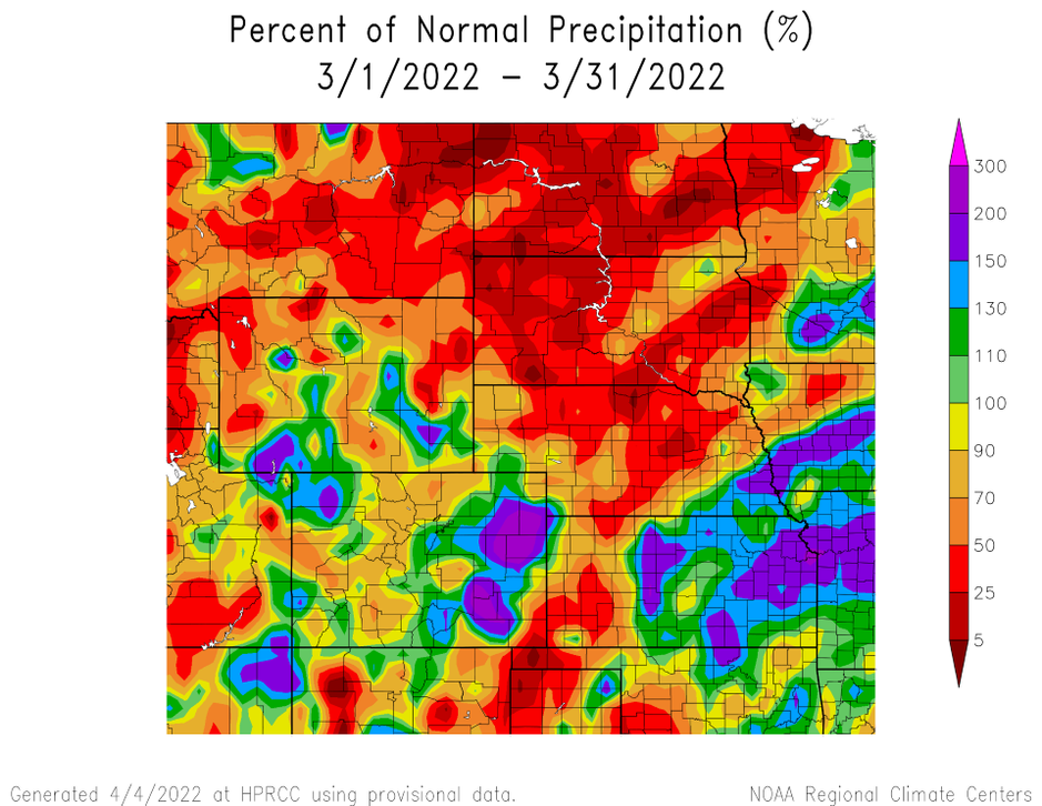
produced by the High Plains Regional Climate Center and are available at: http://hprcc.unl.edu/maps/current .
Precipitation
Precipitation was well below normal again in Nebraska and the Dakotas in March. Pockets of above-normal precipitation were present in eastern Colorado, eastern Kansas, southeastern Nebraska, and parts of Wyoming. The precipitation observed at these locations helped alleviate drought conditions, but deficits remain.
Despite large portions of the region observing below normal precipitation, only two locations ranked in the top 10 driest. Williston, North Dakota recorded 0.06 inches (1.5 mm) of precipitation to rank 5th driest, while Rapid City, South Dakota observed 0.25 inches (6.35 mm) which ranked 8th driest. Several locations have also started the year among the driest on record. In Nebraska, Valentine and Norfolk were the 2nd driest on record since January 1st. Williston and Rapid City also ranked in the top 10 driest since January 1st.
Above normal precipitation this month alleviated drought conditions. Several storms moved across eastern Kansas, which helped remove abnormally dry and improved drought conditions. Precipitation towards the end of the month slightly eased drought conditions in eastern Colorado, however, long-term dryness continues to impact the area. After a very wet March, Casper, Wyoming observed its 3rd wettest start to the year, with 3.29 inches (8.36 cm) of precipitation falling.
The region also experienced its first severe weather of the season. On the 29th, a storm progressed across eastern Kansas with 1 inch (2.54 cm) hail and 60 miles per hour (96.56 km/h) wind gusts. An EF-1 tornado was observed in Jefferson County, with minor damage reported.
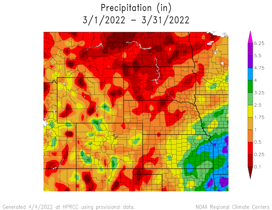
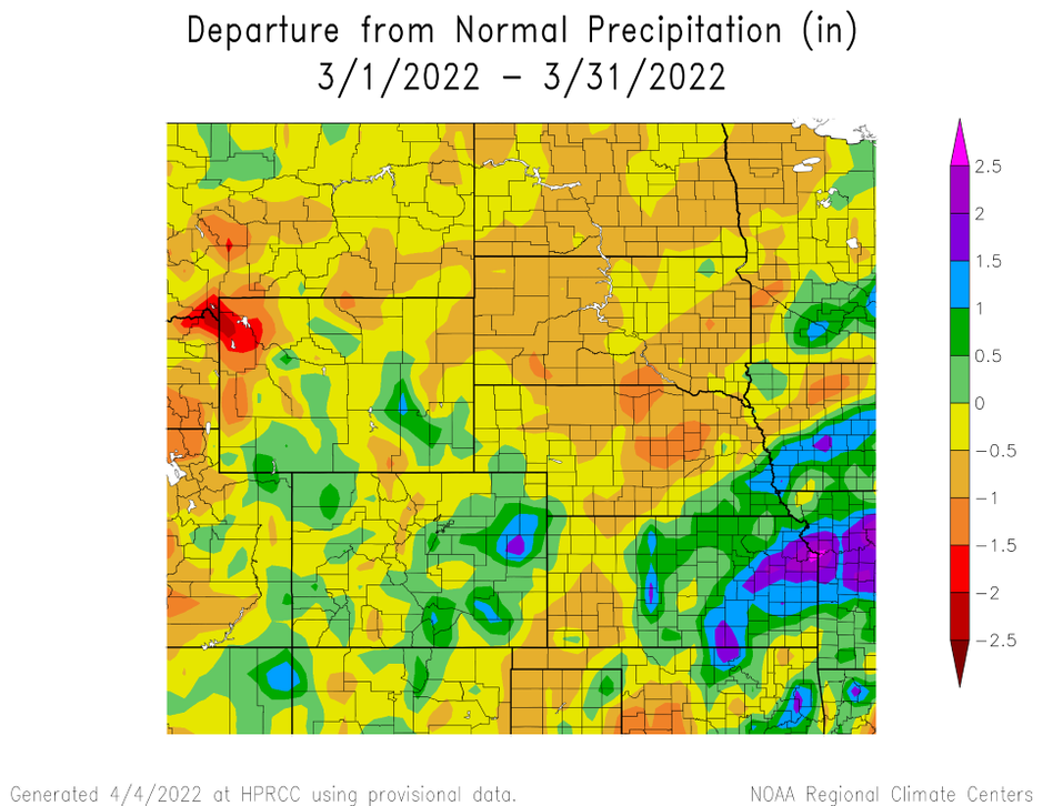
precipitation in inches (bottom) for March 2022. These maps are produced by HPRCC and can be found on the Current Climate Summary
Maps page at: http://hprcc.unl.edu/maps/current.
Snowpack Update
Snowpack for the end of winter remained just below normal for the Upper Missouri River Basin mountains. According to the U.S. Army Corps of Engineers, as of March 27, Snow Water Equivalent (SWE) above Fort Peck Reservoir is currently at 12.2 inches (30.99 cm) which is 79% of the average (1981-2010). The reach between Fort Peck and Garrison Reservoirs is currently 10.4 inches (26.42 cm) which is 76% of the average (1981-2010). In the Plains, areas with snow on the ground at the end of January were observed in southern North Dakota and northeastern South Dakota. Meanwhile, warm and dry conditions resulted in snow-free areas across the remainder of the plains.
Temperatures
Temperatures were near normal for the month of March. Isolated pockets of 8 degrees F (4.4 C) below normal were observed in north-central Colorado. Meanwhile, pockets of above normal temperatures were recorded in northeastern Wyoming, northeastern South Dakota, and southwestern North Dakota.
Despite temperatures being near normal throughout the region, temperatures fluctuated during the month. Temperatures were well above normal on the 21st, reaching 80 degrees F (26.7 C) in the southern High Plains. The highest temperature was recorded in northwestern Kansas, with an observation of 93 degrees F (33.9 C) near Wallace. Opposite of these warm temperatures, much below normal temperatures were recorded from March 10th to 11th. Low temperatures of -25 degrees F (-31.7 C) were observed in the higher elevations of Colorado, South Dakota, and Wyoming. A brisk temperature of -40 degrees F (-40 C) was reported near Yellowstone National Park in Wyoming.
The much above normal temperatures have also coincided with high winds during the month. Red flag warnings were issued on many days in March in all states except North Dakota. Conditions were ripe for fires to break out on the 29th, which led the Storm Prediction Center to issue a rare extremely critical fire day.
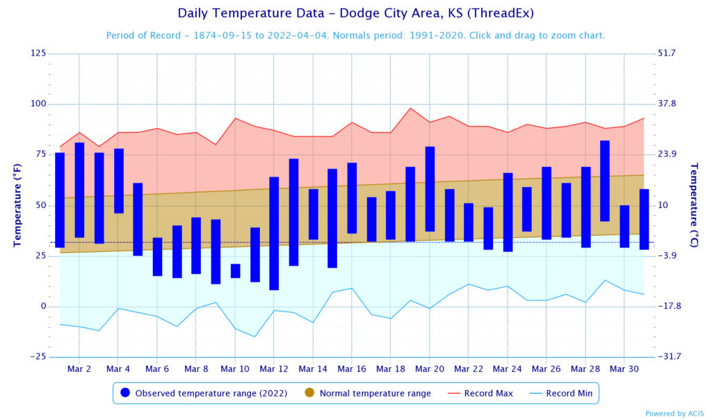
normals values in Dodge City, Kansas.
Drought Conditions
Persistent dryness that has plagued parts of the region continued into March. Conditions rapidly deteriorated across the western parts of Nebraska and South Dakota, while drought intensified in western Kansas.
Exceptional Drought (D4) was reintroduced to the region for the first time since November of 2021. Long-term dryness led to the expansion of D4 into southwestern Kansas and the slight expansion over the course of the month. Another dry month in Nebraska led to a 20 percent increase to severe drought (D2) and the introduction of extreme drought (D3) in the north-central part of the state. Drought conditions also intensified in South Dakota, with 46 percent of the state now experiencing D2. Despite the dryness plaguing the region, some areas received above normal precipitation which led to improvements. Beneficial precipitation in eastern Colorado eased conditions and led to a 24 percent reduction of D2 area coverage for the state. In eastern Kansas, abnormally dry conditions were significantly reduced. Throughout the rest of the region, other improvements and degradations were observed. According to the Climate Prediction Center’s U.S. Monthly Drought Outlook for April, drought development is likely in south-central Nebraska.
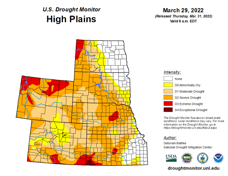
Department of Agriculture (USDA), National Drought Mitigation
Center, U.S. Department of Commerce, and the National Oceanic and
Atmospheric Administration (NOAA). For current Drought Monitor
information, please see: http://droughtmonitor.unl.edu/
Climate Outlooks
According to the Climate Prediction Center, La Niña conditions are likely to continue into the summer. A La Niña advisory is currently in effect. For more information, visit https://www.cpc.ncep.noaa.gov/products/analysis_monitoring/lanina/enso_evolution-status-fcsts-web.pdf
The National Weather Service’s long-range flood outlook through June indicates a high chance of minor flooding across eastern South Dakota and the lower basin. This will decrease over the next three months with chances dropping to below 40% by June. According to the National Interagency Fire Center (NIFC), Kansas, Nebraska, and eastern Colorado have above-normal wildland fire potential throughout April.
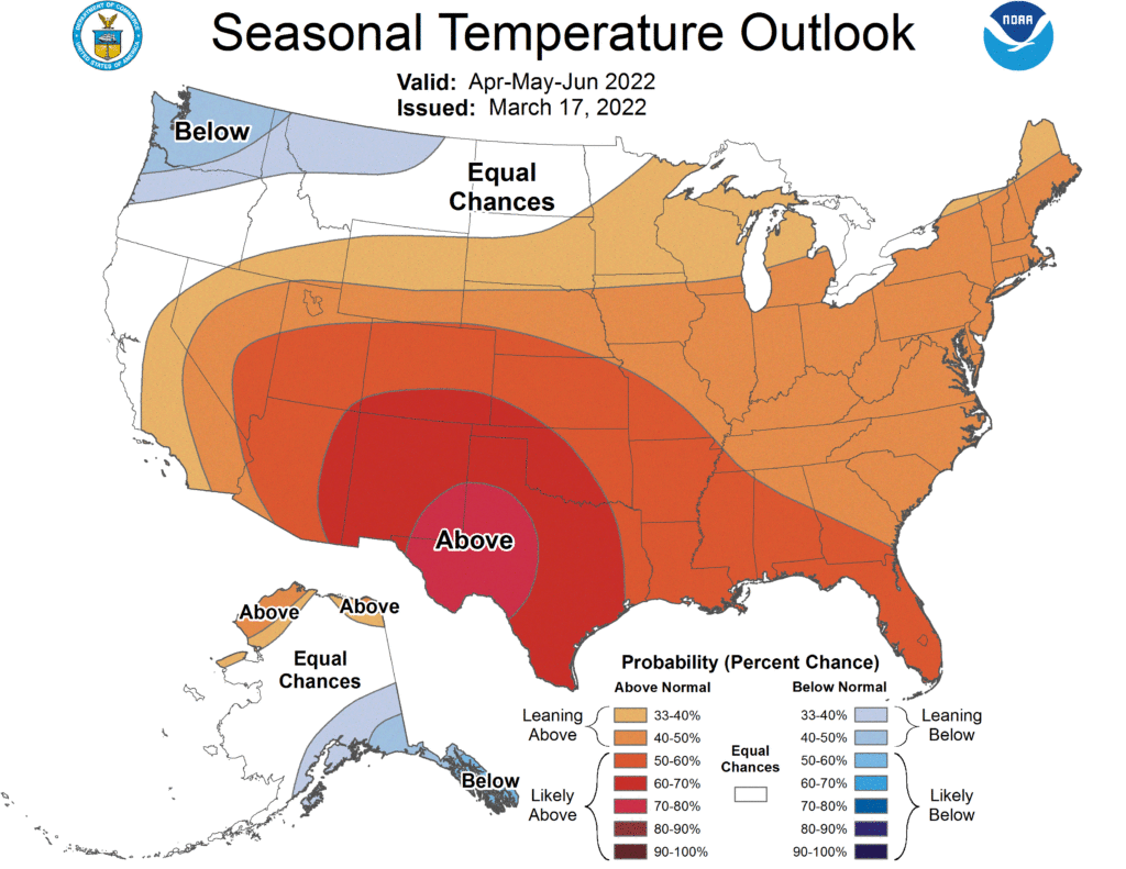
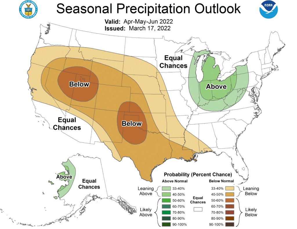
The seasonal temperature and precipitation presented below outlook combine the effects of long-term trends, soil moisture, and when applicable, the El Niño Southern Oscillation cycle (ENSO). To learn more about these outlooks, please visit http://www.cpc.ncep.noaa.gov.
Temperature
The three-month temperature outlook shows an increased chance of above-normal temperatures across the majority of the United States. The highest chances of below-normal temperatures can be observed in the Northwestern United States. In the High Plains, North Dakota and northwestern South Dakota have equal chances of above-, below-, and near-normal temperatures. Meanwhile, the rest of the region has increased chances of above-normal temperatures.
Precipitation
The outlook for the next three months indicates below-normal precipitation across the majority of the western United States. In the Midwest there are increased chances of above-normal precipitation. Across the High Plains there are equal chances of above-, below-, and near-normal precipitation in North Dakota and northeastern South Dakota. The rest of the region has increased chances of below-normal precipitation.
Drought
The U.S Seasonal Drought Outlook released on March 31st indicates drought conditions are expected to persist across the Southwest and High Plains over the next three months. Drought conditions are expected to remain and development is likely in eastern Kansas and south-central Nebraska.
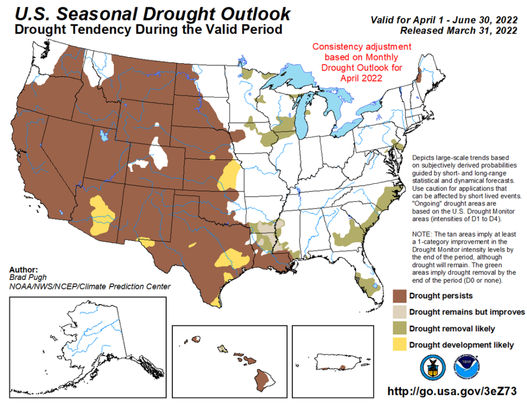
three-month precipitation probability outlook (middle), and the U.S.
Seasonal Drought Outlook (bottom). For more information on these
outlooks, produced by the Climate Prediction Center, see:
http://www.cpc.ncep.noaa.gov.
Station Summaries: By the Numbers
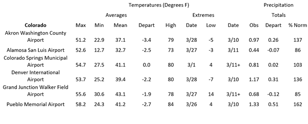

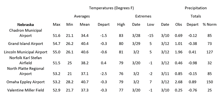
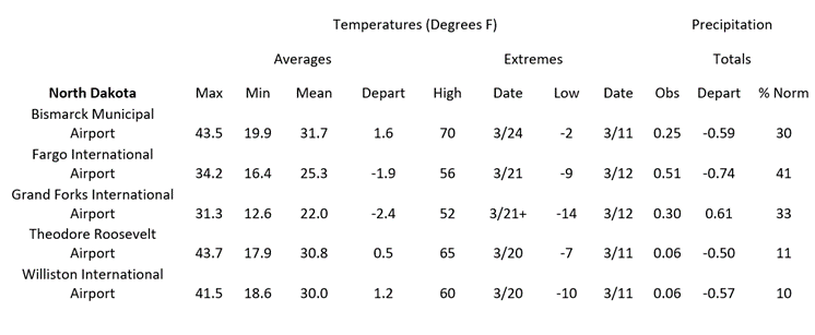
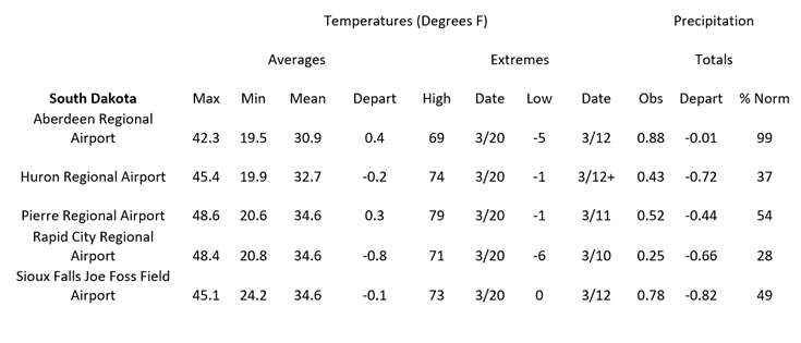
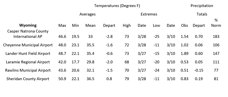
Data are retrieved through the Applied Climate Information System (ACIS) and are available online through the CLIMOD system.
For more information please contact us: http://www.hprcc.unl.edu/contact.php
Download PDF below:
