December 2021 Climate Summary
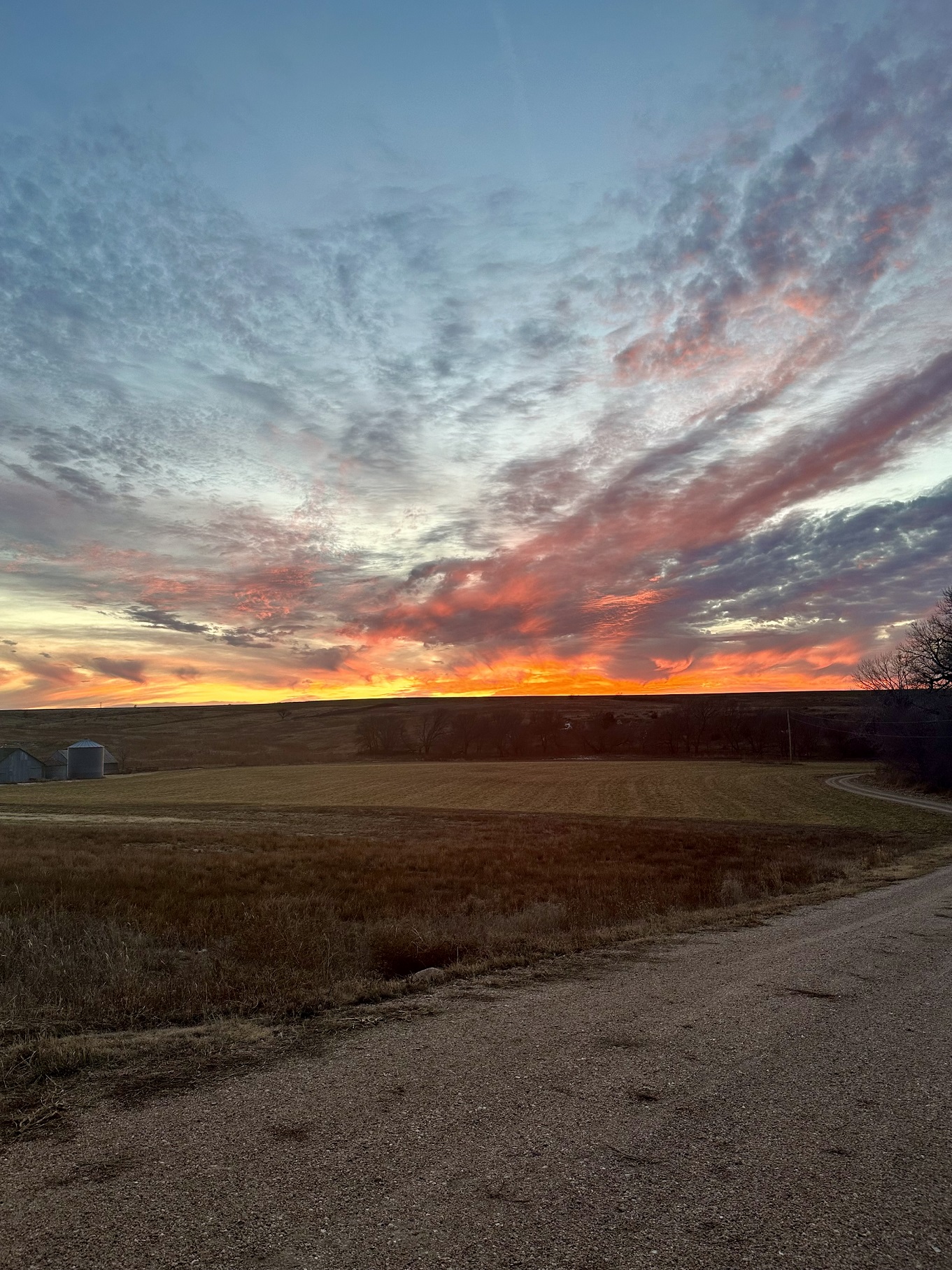
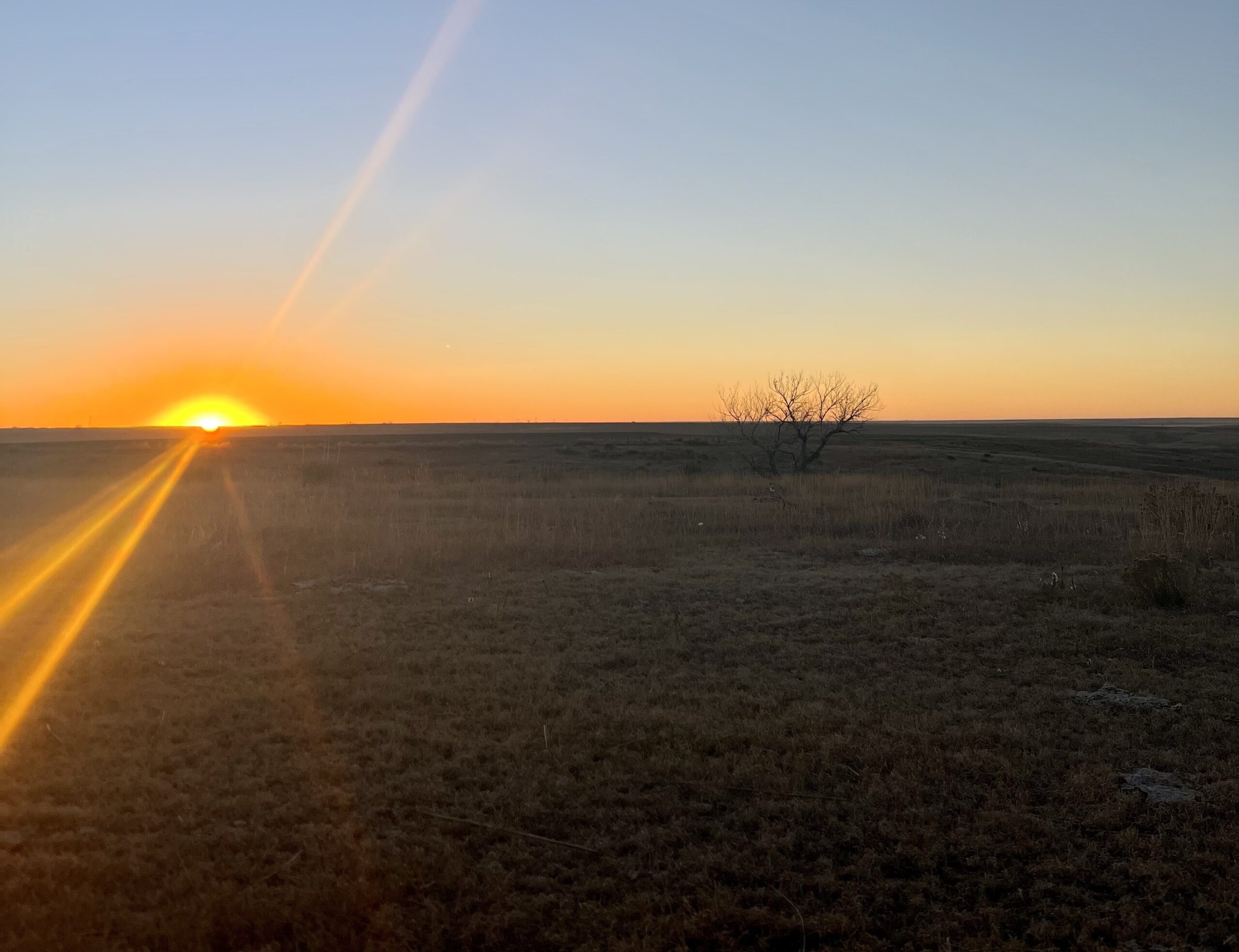
Sunset in Western Kansas, Photo Courtesy Gannon Rush
Active End to the Year for the Region
Warmer temperatures dominated most of the High Plains, while precipitation varied across the region. The southern portion of the region was dry, while drought-stricken parts of North Dakota and western Colorado received beneficial precipitation. The warm and dry conditions in the southern portion of the region attributed to several noteworthy events.
A strong low-pressure system moved across the southern part of the region, leaving a trail of destruction in its wake. In Colorado, a 107 mph (172 km/h) wind gust was recorded in Lamar. The winds there caused power outages and damage to homes. To the east, Kansas experienced severe winds which led to substantial amounts of dust being stirred up. These dust storms resulted in the closure of several highways and numerous crashes along Interstate 70 in the western part of the state. The dry weather and intense winds also contributed to an outbreak of wildfires in north-central Kansas. Meanwhile, in neighboring Nebraska, both severe storms and snow occurred in a several-hour span. An extremely unusual derecho that was strong and fast-moving crossed the state, with numerous 75 mph (121 km/h) plus wind gusts and dozens of tornadoes reported. After the storm had passed, temperatures significantly dropped which led to snow. This light snowfall and the remaining high winds led to the first issuance of a Snow Squall Warning by the National Weather Service in Hastings, NE.
At the end of the month, a devastating wildfire broke out north of Denver, CO on the 30th. Winds gusted from 70 to 100 mph (113 to 161 km/h), with a maximum gust of 115 mph (185 km/h) recorded in Arvada. These fires rapidly spread across the foothills and engulfed up to 1,000 homes, making this among the most destructive fires in Colorado state history.

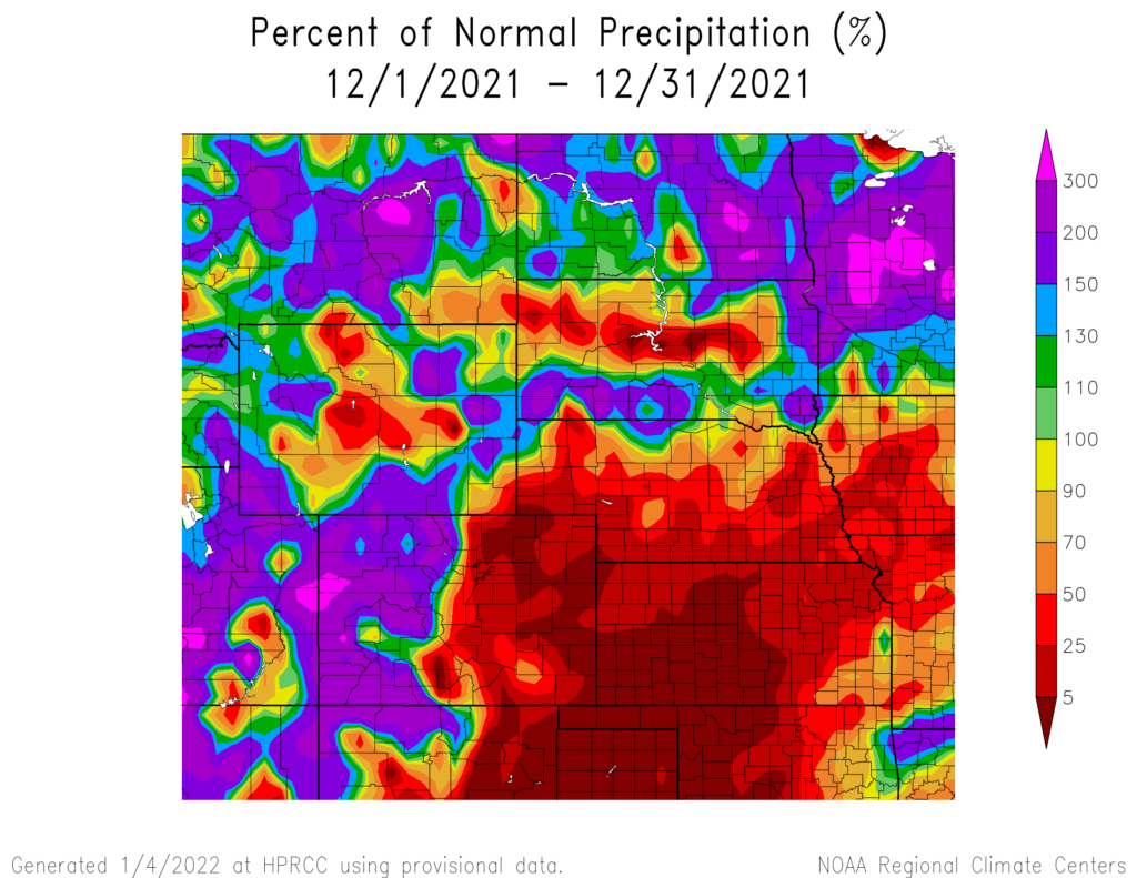
produced by the High Plains Regional Climate Center and are available at: http://hprcc.unl.edu/maps/current .
Precipitation
Precipitation varied across the High Plains for December. The northern plains including North Dakota, western Colorado, and portions of Wyoming and South Dakota observed above normal precipitation for the month. In the southern High Plains, below normal precipitation was recorded, with areas in Kansas and eastern Colorado receiving less than 5 percent of their normal precipitation.
This precipitation gradient resulted in some locations ranking in the top 10 wettest and driest December on record (see page 6 for December monthly rankings). Wichita, KS observed their driest December on record with 0.01 inches (0.25 mm) of precipitation. Chadron, NE tied with 2010 and other years for the driest December on record, observing a trace of precipitation. While the southern High Plains observed below normal precipitation, on December 15th an intense derecho moved through the region impacting Colorado, Nebraska, and Kansas with damaging winds, rain, tornadoes, and dust.
The largest precipitation was observed in western Colorado, with areas receiving over 3 inches (76 mm) above normal. Grand Junction, CO observed their wettest December on record with 2.08 inches (53 mm) exceeding their previous record of 2.05 inches (52 mm) in 2007.
Snowfall also varied across the region. Sisseton, SD observed their 2nd snowiest December on record with 20.3 inches (52 cm) of snow. Grand Forks, ND observed their 3rd snowiest December on record with 27.0 inches (69 cm) of snow, with the record being 36.0 inches (91 cm) and set in 2010. In contrast, Topeka, Wichita, and Dodge City, Kansas observed their least snowy December on record, tied with multiple years, with 0.00 inches of snow.
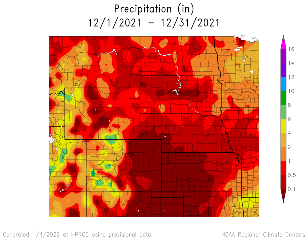

precipitation in inches (bottom) for December 2021. These maps are
produced by HPRCC and can be found on the Current Climate Summary Maps page at: http://hprcc.unl.edu/maps/current.
Streamflow
Dry conditions in the early winter season resulted in the Upper Missouri River Basin mountain snowpack levels being below normal for December. According to the U.S. Army Corps of Engineers, as of December 28th, Snow Water Equivalent (SWE) above Fort Peck Reservoir is currently at 6.1 inches (mm), while the reach between Fort Peck and Garrison Reservoirs is 6.2 inches (mm). While the early season snowpack is below normal, it is still early in the season with ample time for the snowpack to return to normal. In the Plains, areas with snow on the ground at the end of December were observed in the Dakotas. Meanwhile, warm and dry conditions resulted in snow-free areas across the remainder of the plains.
Temperatures
Above normal temperatures prevailed throughout most of December. Except for North Dakota, much of the region recorded much above normal temperatures. The southern part of the region experienced temperature departures of 6.0 – 10.0 degrees F (3.3-5.6 degrees C) above normal. This led to many areas ranking in the top 10 warmest December on record. Grand Island, NE (period of record 1895-2021) and Norfolk, NE (period of record 1893-2021) both observed their warmest December on record. Several locations in both Colorado and Kansas recorded their second warmest December because of these much above normal temperatures. Please see page 6 for additional rankings.
On the 15th, an extremely unusual and extreme event occurred in the High Plains. Temperatures in the southern part of the region exceeded 70.0 degrees F (21.0 degrees C) with departures up to 39.0 degrees F (21.7 degrees C) above normal in some areas. Many locations set their daily high record and their warmest temperature on record for December. Omaha, NE (period of record 1871-2021) observed their warmest December day on record, with a temperature of 74.0 degrees F (23.3 degrees C). These warm conditions lasted through most of the day until an extreme pressure system passed through, causing temperatures to drop over 40 degrees F (22.2 degrees C). The abnormally high temperatures combined with the significant winds from the pressure system led to large wildfires breaking out in north-central Kansas. The smoke from these fires was carried across Kansas and Nebraska, with the haze being seen as far away as Chicago. Over 163,000 acres (66,000 hectares) were burned before the fires were contained.

and normals values in Norfolk, Nebraska.
Drought Conditions
The trend of above normal temperatures and dryness across the southern High Plains continued through the month of December. Drought conditions continued their spread and intensified in Kansas, Colorado, and Nebraska while the Dakotas observed improvements. Despite the intensification of drought conditions this past month, the region remained free from exceptional drought (D4) conditions.
Kansas experienced the most significant degradations to drought conditions this past month. The amount of the state covered in moderate drought (D1) to D4 increased from 19 percent to over 50 percent during the course of the month. Abnormally dry (D0) conditions now also cover 73 percent of the state. In Colorado, the entire state is now engulfed by D1 to D4 conditions. Despite minimal change to the percentage of the state in severe drought (D2), conditions in the western part of the state improved while the eastern parts declined. Above normal precipitation in the eastern Dakotas led to the reduction of abnormally dry and drought conditions. Throughout the rest of the region, other improvements and degradations were observed. According to the U.S. Monthly Drought Outlook for January, drought improvement is likely in western Wyoming.
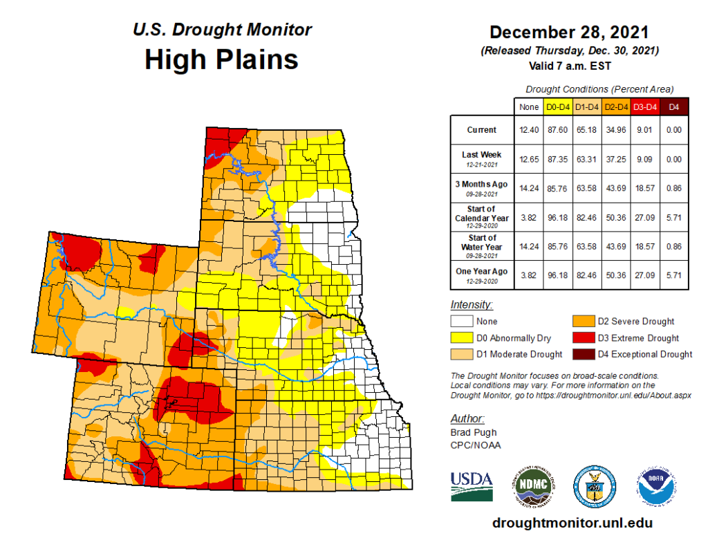
Department of Agriculture (USDA), National Drought Mitigation
Center, U.S. Department of Commerce, and the National Oceanic and
Atmospheric Administration (NOAA). For current Drought Monitor
information, please see: http://droughtmonitor.unl.edu/.
Climate Outlooks
According to the Climate Prediction Center, La Niña conditions remain present and are likely to continue throughout the winter season. A La Niña advisory is in effect. For more information, visit https://www.cpc.ncep.noaa.gov/products/analysis_monitoring/lanina/enso_evolution-status-fcsts-web.pdf
The National Weather Service’s long-range flood outlook through March indicates a continual decrease in the chance of minor flooding. There is a greater than 50 percent chance of minor flooding in areas of the lower Missouri River Basin for January and that will continue to decrease through March where it becomes a less than 5 percent chance. According to the National Interagency Fire Center (NIFC), in the High Plains, Western Kansas and Eastern Colorado have above normal wildland fire potential and that is expected to remain through April.
The seasonal temperature and precipitation outlooks combine the effects of long-term trends, soil moisture, and when applicable, the El Niño Southern Oscillation cycle (ENSO). To learn more about these outlooks, please visit http://www.cpc.ncep.noaa.gov.
Temperature
The three-month temperature outlook shows an increased chance of above normal temperatures across the east coast, southern plains, and parts of the southwest. The highest chances of below normal temperatures can be observed in the Northwestern United States. In the High Plains, most of the region has equal chances of above, below, and near normal temperatures, aside from Kansas, and southern Colorado which has increased chances of above normal temperatures.

Precipitation
The precipitation outlook for the next three months indicates below normal precipitation across the Southwest and Southeast of the United States. In the Midwest and Northwest, there are increased chances of above normal precipitation. Across the High Plains there are equal chances of above, below, and near normal precipitation, aside from southern Colorado which has increased chances of above normal precipitation.

Drought
The U.S Seasonal Drought Outlook released on December 31st indicates drought conditions are expected to persist across the Southwest and western High Plains over the next three months. Drought conditions are expected to remain but show minor improvements in the Northwest and California, with some areas likely to observe drought removal. Drought development is likely in the Southeast and south Texas.

three-month precipitation probability outlook (middle), and the U.S.
Seasonal Drought Outlook (bottom). For more information on these
outlooks, produced by the Climate Prediction Center, see:
http://www.cpc.ncep.noaa.gov
Station Summaries: By the Numbers


Download PDF below
